Introduction
Neyshabur and Firuzeh Counties include many geotourism attractions, which, along with their cultural, historical, and literary values, can be suitable destinations for all types of tourists. This region has experienced many changes over the centuries due to its geographical location, although it is still unknown and abandoned. Geodiversity of the region with the stories and myths that exist mostly in the oral tradition make these regions appropriate for geotourism with an emphasis on cultural geomorphology. It is noteworthy that this new geotourism marketing sector can be a solution to preserve these myths and oral traditions.
Cultural geomorphology is the study of a land's geomorphological components besides the landscape's cultural features and its interaction with cultural heritag (archaeology, literature, history, architecture, etc.). Everywhere where geosites are involved with the folk culture of local people, it can be said that the geosite has a high potential for cultural geomorphology (Khoshraftar 2009a, b). The Maestrazgo Cultural Park in Spain, the Araripe UNESCO Global Geopark in Brazil, Yellowstone National Park in the USA, and The Dolaucothi Gold Mines in Wales, England are good examples (Edwards & i Coit 1996).
This study has two major purposes: 1) to identify primary geosites with cultural geomorphology and, 2), to investigate appropriate solutions to promote geotourism with an emphasis on cultural geomorphology. According to the National Vision Plan of Iran, promoting geotourism and diversification of tourism forms and development of tourism services and products are strategies and policies of tourism development designed to overcome the challenges related to the tourism industry in Iran. We can take a step towards achieving these goals by promoting geotourism and mine tourism, with emphasis on cultural geomorphology heritage sites in Neyshabur and Firuzeh counties.
Cultural Geomorphology
The concept of cultural geomorphology consists of two parts: geomorphology and culture. There are many definitions of geomorphology, a key one being that of the International Association of Geomorphologists (IAG), “Geomorphology is the interdisciplinary and systematic study of landforms, their landscapes and the earth surface processes that create and change them” (IAG 2013).
Moreover, UNESCO defines culture as “the set of distinctive spiritual, material, intellectual and emotional features of society or a social group, that encompasses, not only art and literature, but lifestyles, ways of living together, value systems, traditions, and beliefs” (UNESCO 2001: p. 3).
In recent decades, the concept of cultural geomorphology has emerged in academic research (Panizza & Piacente 2009; Sahariah et al. 2013). Cultural geomorphology has been a part of the activities of geography, which investigate the natural and human aspects of landscapes (Sahariah et al. 2013).
Caseldine and Turney (2010) noted that there are internal interrelationships between geomorphic landscapes and the development of material and immaterial aspects of human activities in many places and indicated that the appearance and different cultural changes have been developed based on the time scales of thousands of years. The geomorphic landscape may come from the distant past for different reasons, such as strangeness (e.g., South China Karst), grandeur (e.g., Mount Fuji in Japan), color and contrast (e.g., badlands colored landscapes), geomythology (e.g., Takht-e Soleymān–Takab in Iran; Khoshraftar & Torabi Farsani, 2019, and the Devils Tower in Wyoming, USA) have been important to people and have formed a part of people's culture for many centuries (Khoshrahtar 2009a, b).
In recent decades, such sites have been called by terms such as geosite, geotope, geoscience sites, and are better known than other geoheritage sites. Reynard (2004) argued that geosites are important in terms of scientific, cultural-historical, aesthetic, and economic-social aspects.
Panizza and Piacente (2009) were the first researchers to use the concept of cultural geomorphology and they defined it as a field in which the geomorphological features of land include the cultural components of the landscape and its interaction with cultural heritage such as archaeology, history, architecture, etc. These authors argued that in cultural geomorphology studies there are five steps and describing geological and geomorphic processes is the first step. Pereira and Martins (2016) believed that cultural geomorphology strives to support geomorphological heritage from the viewpoint of cultural landscape related to history, literature, architecture, archeology, intangible cultural heritage, etc. to illustrate the geosites’ values. Reynard and Giusti (2018) demonstrated that nature and human culture play axial role in developing cultural landscapes and geologic features or landscapes has also a vital role in cultural or historical events.
In regional studies, Knight and Harrison (2013) considered the relationship between geomorphology, geoheritage sites, and cultural values in Cornwall, UK. Serrano and González-Amuchastegui (2020), through inventory and assessment of geomorphosites in the north of Spain, illustrated that territorial tourism management planners should pay equal attention to natural (geoheritage sites) and cultural components. Soares & Bateira (2020) studied the cultural geomorphology of Douro River, Portugal, presenting geological and geomorphological characteristics in relation to the economic, social, and cultural evolution of the area. de Tarso Castro et al. (2021) suggested that geo-mining heritage sites that involved cultural values are appropriate areas for promoting cultural geomorphology.
Ferreira (2022) studied cultural geomorphology values of a territory located at Arada and S. Macário mountain areas and the valleys of the rivers Sul and Vouga (municipality of São Pedro do Sul), Portugal, through geographic information technologies and the results illustrated that geoheritage can be applied as a complementary tourist resource and cultural geomorphology values can improve public perception of natural and cultural heritage in depopulation and rural abandonment. Lajczak and Zarychta (2022) introduced Krakow, Poland, as a geotourism destination with cultural geomorphology values such as an old salt mine in Wieliczka town, underground museums etc.
Undoubtedly, geomorphologists who study cultural geomorphology can provide a balanced approach to identifying, preserving, and protecting valuable landscapes and geosites at the local, national and global levels. At first, cultural geomorphology researchers emphasized the importance of preserving cultural values on geomorphological sites, and in recent decades, geotourism has been paying particular attention to the aesthetic aspects as well as cultural values in geoheritage sites.
It is noteworthy that the topic of cultural geomorphology is a current consideration in Iran, and here we explore the inventory, identification, and qualitative description of cultural geomorphology of geosites in Neyshabur and Firuzeh Counties to introduce a new theme in promoting geotourism of Iran.
Methodology
Neyshabur and Firuzeh Counties (Fig. 1) are selected as case studies. They are in Razavi Khorasan Province in north-eastern Iran. Firuzeh is known as a mine tourism destination because of its turquoise mines. Neyshabur is one of the most famous cultural and literary capitals of Iran and the tombs of some poets such as Omar Khayyam, Attar of Nishapur, etc. are located there. In addition, the tomb of Mohammad Ghaffari, better known as Kamal-ol-Molk, an Iranian painter, is in Neyshabur.
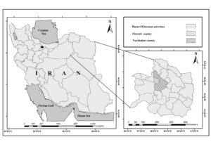
Figure 1. Geographical location of Neyshabur and Firuzeh Counties, Razavi Khorasan Province, Iran.
Regional geology includes the turquoise mines, said to be the most famous and high-quality turquoise in Iran, fossil sites, salt mines, and geological sites. This region experienced historical events such as the migration of Imam Reza-the eighth Imam of Twelver Shias- to this area and the Mongol invasion of Persia and the devastation of Neyshabur.
Moreover, there are many literary stories such as the poems of Shahnameh, long epic poems written by the Persian poet Ferdowsi, oral traditions, myths, and cultural and historical stories involved with geoheritage sites. In this study, we strive to use these stories and myths as interpretative tools for geological education and to make them more attractive.
For this, we designed an interview form which included semi-structured questions. The content validity of the interview form was evaluated by the CVR formula, in which Ne is the number of experts indicating "essential" and N is the total number of experts. The numeric value of the content validity ratio is determined by the Lawshe Table (Wilson et al., 2012).
CVR = (Ne - N/2)/(N/2) (1)
A content validity ratio of 0.75 indicated a good validity of the interview form. Interviews were conducted by tour guides, local communities, geologists and experts in the fields of geography, geomorphology, culture and history and the data reached saturation point at the 13th interview. It is worth mentioning that because of the Coronavirus wpidemic, phone and social media interviews were used as well as field trips and face to face interviews. The data was collected from spring 2021 to autumn 2021. The data was analyzed using thematic analysis (open and axial coding), as one of the best known methods in qualitative research.
Results
The thematic analysis identified that 19 primary geosites with cultural geomorphology potential (Table 1): Yekeh Kūh , Shotor Sang Rock (Fig. 2A), Pir Hassan Chupan Rock, Kūh-e Do Barādar (Dual rocky peaks), Āsheq Kūh And Māhrokh Kūh , Hussain Asghar Shrine Erosion Stones, Quchgar Mountain Dizbad Rock located in Nohesar Dizbad castle, Takht Hulagu or Takht Palang, Si sar Cave, EBRĀHĪM B. ADHAM Cave or Haft Ghar (Seven Caves), Kelidar leopard Cave (Palang Kelidar cave), Neyshabur salt cave, Alaodole salt cave and Amarlou salt cave (Fig. 2B), Turquoise Mine (Fig. 2C), Si Sar Lake, Cave Spring of Hossein Asghar shrine, Garmab Thermal Spring, Nohasar Dizbad Spring, Kahlan Spring, Deh Sorkh Spring.
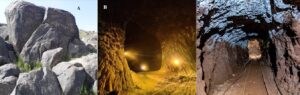
Figure 2. The primary geosites with cultural geomorphology potentials in Neyshabur and Firuzeh Counties. A: Shotor Sang Rock; B: salt cave in Neyshabur; C: Turquoise Mine. (source: Google Maps).
Table 1 illustrates the geological processes and the cultural values, myths, and stories related with each geosite.
Primary geosites | Geological and geomorphological processes | Myth or Story |
Yekeh Kūh
| There are two geological reasons for this cone-shaped mountain in the middle of the vast plain: 1) Creating a volcanic mountain that rises in the middle of the plain. 2) Its creation can be due to the intrusive mass that has been exposed by the erosion of the upper layers of this intrusive mass. | 1) According to the local communities’ belief when a war between the Army of Islam and the infidels (good and evil) happened in this area, a mountain was separated from its original location so that the Army of Islam could stay safe under its shelter. 2) Also, according to the local people's belief, if a person cuts down shrubs and thorn bushes from around and on the surface of this mountain an unfortunate event will happen to whoever collected them. 3) Another story that is also told about this mountain is the story of forty girls who came to this mountain and disappeared here, and their clothes were transformed into plants and shrubs. |
Shotor Sang Rock | Near Shotor Sang village, there is a large iron mine, and there is iron in the rocks and stones. | A rock in the shape of a sitting camel has created the belief among local people that this camel came here in the distant past and calls its baby on Friday nights. The local communities touch the chest of the camel with wet hands and their hands become red, and they believe that this is the redness of the blood that came out of the chest of this camel. |
Pir Hassan Chupan Rock | It is a volcanic boulder that has a big hole in the middle due to mechanical erosion (the coldness of the region and snowfall in winter and the day and night fluctuations of the weather). It is noteworthy that the hole is big and humans can pass through it. | In the past, people believed that if a child had a severe cold with a cough or whooping cough, they would take the child there for treatment. The child by passing through the hole of that stone would be healthy.
|
Kūh-e Do Barādar (Dual rocky peaks) | Two tall and almost identical hills of conglomerate | In ancient times, two brothers who planted wheat together in their fields, at the time of harvest, divide their share into two equal stacks. At night, the older brother, who is married, pours a few buckets of his stack on his brother's stack, so that his brother, who is single, decides to have a family. On the other hand, the unmarried brother, because the older brother is married and has more expenses, pours a few buckets of his stack on his brother's stack. When they wake up in the morning, they see that because of their generous behavior, God has blessed them so much that both threshing floors have risen in the form of mountains, and these two mountains are the same two threshing floors. |
Āsheq Kūh And Māhrokh Kūh
| These two mountains are volcanic | The name Māhrokh Kūh (Marco Mountain) was because this mountain was located on the route of the Silk Road and Marco Polo passed through this area. |
Hussain Asghar Shrine Erosion Stones | Erosion forms that are located on top of metamorphic mountains
| 1) There are erosion marks in the form of gazelles' footprints on the flat rocks of this area. Local people believe that when the dead body of one of the grandsons of the prophet Muhammad was brought to this area, gazelles came here, and their footprints remained on the rocks. 2) There is a pillar-shaped erosional rock known as Rostam's mace (Rostam is a legendary hero in Persian mythology). 3) There is a rock with a big hole near Hussein Asghar shrine and people believed that if a person throws a stone from a distance of 30 to 40 meters, and it passes through the hole in the rock, that person will be able to visit the Kaaba that year. |
Quchgar Mountain Dizbad Rock located in Nohesar Dizbad castle | Mechanical erosion on the metamorphic rocks | There are some erosion features like horse footprints which the local communities believed to be the footprints of the horse of Ali ibn Abi Talib (cousin, son-in-law, and companion of the Islamic prophet Muhammad)
|
Takht Hulagu or Takht Palang | Rock of conglomerate | According to historical narratives, at the time of the Mongol attack on Iran, Hulagu Khan (a Mongol ruler who conquered much of Western Asia) entered to this area by horse. Due to the observation of leopards in this area, this bedrock is sometimes known as "Leopard bed". |
Si sar Cave | A karst cave with a combination of chalk and limestone was created by the water erosion and dissolution method.
| In the past, the local people believed that the river inside this cave is connected to the Tigris and Euphrates rivers in Iraq and had a way to Iraq from underground. There is also a legend that one day a person embedding his money in his cane enters a cave and his cane falls into an underground river, which makes him very disappointed. Sometime later, this person goes to visit Karbala and when he was sitting by the Tigris and Euphrates rivers, he saw a person who took a cane similar to his cane out of the water, he bought the cane from the man and found his money in the cane. |
EBRĀHĪM B. ADHAM Cave or Haft Ghar (Seven Caves) | Located on mount Binalud and included red soil and the cave created by erosion | This cave was the retreat of mystics like EBRĀHĪM B. ADHAM |
Kelidar leopard Cave ( Palang Kelidar cave) | Located in mount Binalud and was created by erosion | Kelidar is a novel written by Mahmoud Dowlatabadi in Persian. The novel consists of 10 books in 5 volumes. The book was written in 15 years and includes Iranian folkloric themes. Kelidar refers to the name of a mountain and a village in Khorasan, where the events of the novel take place. |
Alaodole salt cave and Amarlou salt cave
| The southern slopes of Binalud mountains have abundant deposits of chalk and salt
| During the exploitation of the mine in the past, the mine collapses many times, because of this, the local people believed that supernatural beings and demons exist in the mine, which do not allow them to use the mine, and for this reason, this mine remains abandoned for many years. Currently, with the arrival of modern equipment and loaders, salt harvesting has started again |
Turquoise Mine | Turquoise is an opaque, blue-to-green mineral included hydrated copper and aluminum phosphate | The kings believed that carrying turquoise would win the war. In addition, in the past, people believed that the change in the color of turquoise reveals the infidelity of a woman to a man, and they believed that the reflection of the moon on the turquoise stone is auspicious and protects them from the devil, and some believed that looking at turquoise has a healing effect on the eyes. |
Si Sar Lake | Karst lake | 1) In the past, it was decided to dig a canal to mix the water of this lake with fresh water and use it to irrigate the agricultural land. When the workers reach the lake it was nighttime, and the next morning, the people who follow them faced the dead body of thirty workers there. 2) Also, in the past, the local communities believed that this water is holy. |
Cave Spring of Hossein Asghar shrine | Most caves are created when slowly-moving water dissolves, or eats away at limestone rock karstification, creating spaces, caverns, and tunnel-like passages, and finally, the waters come up and create a cave spring. | In the old days, when the sister of one of the grandsons of the prophet Muhammad came here to meet her brother, enemies attacked, but by God's permission, the mountain opened, and she hid in the mountain. In addition, the locals believed that the shrine of Anahita an Iranian goddess (goddess of water) was located here. |
Garmab Thermal Spring
| This spring is the only light mineral hot spring in the region, and this is calcium sulfate water, which is scientifically useful for skin and muscle diseases. | There is a story among the villagers that states that when the Russians attacked Iran and took the cities of Neyshabur, when they came to this spring to draw water, the water turned red, but it was always clean and clear for the local people. |
Nohasar Dizbad Spring | This spring was created due to the infiltration of water caused by the melting of snow of Binalud mountains and reaching impermeable layers in this area, and it has clear blue water similar to mineral water. | The story is about the spiritual journey of a person named Imam Gholi: he saw his spiritual leader (Imam Zulfiqar Ali) riding a horse and asked him to show him the path of truth. Springs are created in the direction of their movement.
|
Kahlan Spring | This spring was created due to the infiltration of water caused by the melting of snow of the Binalud mountains and reaching impermeable layers in this area | There is a story that when Imam Reza entered this region, there was a spring there whose water was low, and when Imam Reza came, its water became abundant. Since then, this water has been holy to the people. |
Deh Sorkh Spring | This spring was created due to the infiltration of water caused by the melting of snow of the Binalud mountains and reaching impermeable layers in this area | It is narrated that when Imam Reza came to Tus, he reached this village near the noon call to prayer and asked for water to wash, but there was no water with the caravan, so the Imam dug the ground with his hands and water began to boil from the ground. This spring is still available in that area. |
Analysis of the data indicates five appropriate solutions (themes) to promote cultural geomorphology: marketing, government support, research and identification of geological heritage sites, local empowerment, and development of new products and services to offer to tourists with geo-themes to promote geotourism (Table 2).
Table 2. Appropriate solutions to promote geotourism with emphasis on cultural geomorphology obtained from interviews
Theme | Sub-themes |
Marketing to introduce geotourism with emphasis on cultural geomorphology | • Organizing a pilot geotourism tour with an emphasis on cultural geomorphology heritage sites by nature tourism agencies • Marketing and advertising in the field of geotourism with an emphasis on mines and cultural geomorphology • Introduction of geosites through Iran's Minister of Cultural Heritage, Tourism, and Handicrafts • Introducing the geotourism potential of the region through social media, leaflets, brochures, etc. • Holding conferences, meetings, and photo exhibitions related to geotourism and cultural geomorphology heritage sites in the region • Holding high-quality geotourism tours and benefiting from word-of-mouth marketing • Finding a suitable target market for mine tourism and geotourism with an emphasis on the cultural geomorphology of the region |
Government support for geotourism with an emphasis on cultural geomorphology | • Government support for geotourism with an emphasis on cultural geomorphology • The government's support for the private sectors of the region in the field of geotourism • Creating geotourism infrastructure and facilities • Making the necessary infrastructure and giving the government permit for turning abandoned or semi-active mines into mining museums, mining parks, eco-museums • Government support for new ideas that fit the cultural geomorphology of the region • Government support for voluntary cooperation and non-governmental organizations (NGOs) regarding sustainable tourism, education, culturization, environmental protection, and promoting geotourism |
Research and identification of geological heritage sites with emphasis on cultural geomorphology | •Identifying the geological heritage in the region and providing protection strategies for them, such as the fossils of Qoruneh and Baqi villages • Identification of inactive and abandoned mines under the supervision of the Geological Survey and Mineral Exploration of Iran to consider turning them into mining museums, mining parks, ecomuseums, or salt hotels • Identifying existing local stories, myths, narratives, and legends and teaching them to guides and local people as a marketing tool |
Local empowerment | • Empowering local communities regarding communication with tourists • Empowering local communities by creating geo-products • Introducing the geological heritage sites of the region to local communities • Educating local people to promote geotourism with emphasis on geosites with cultural geomorphology values • Educating local tour guides to promote geotourism with emphasis on geosites with cultural geomorphology values |
Development of new products and services to offer to tourists with geo-theme | • Using salt mines in geotourism and health and wellness sectors and turning them into salt hotels • Production of geo-products according to cultural components and geotourism elements of the region • Development of geotours with emphasis on cultural geomorphology values |
The experts recommended seven sub-themes for the marketing strategy as follows: organizing a pilot geotourism tour with an emphasis on cultural geomorphology heritage sites by nature tourism agencies; marketing and advertising in the field of geotourism with an emphasis on mines and cultural geomorphology; introduction of geosites through Iran's Minister of Cultural Heritage, Tourism and Handicrafts; introducing the geotourism potential of the region through social media, leaflets, brochures, etc.; holding conferences, meeting, and photo exhibitions related to geotourism and cultural geomorphology heritage sites in the region; holding high-quality geotourism tours and benefiting from word-of-mouth marketing; finding a suitable target market for mine tourism and geotourism with an emphasis on the cultural geomorphology of the region.
In addition, government support for geotourism with an emphasis on the cultural geomorphology theme could support the private sectors of the region to create geotourism infrastructure and facilities, invest in the necessary infrastructure themselves, provide permits to turn abandoned or semi-active mines into mining museums, mining parks, eco-museums, new ideas that fit the cultural geomorphology of the region, and voluntary cooperation and non-governmental organizations (NGOs) for sustainable tourism, education, culturization, environmental protection and promoting geotourism.
The experts mentioned that research and identification of geological heritage sites with an emphasis on cultural geomorphology are needed in Neyshabur and Firuzeh Counties: to identify the geological heritage in the region and provide protection strategies, such as the fossils of Qoruneh and Baqi villages; to identify inactive and abandoned mines under the supervision of the Geological Survey and Mineral Exploration of Iran to turn them into mining museums, mining parks, ecomuseums or salt hotels; and to identify existing local stories, myths, narratives and legends and teach them to guides and local people as a marketing tool.
Further analysis demonstrated that local empowerment can play an axial role in promoting geotourism in the region. Empowering local communities regarding communication with tourists and creating geo-products, introducing the geological heritage sites of the region to local communities, educating local people to promote geotourism with an emphasis on geosites with cultural geomorphology values, and educating local tour guides to promote geotourism with an emphasis on geosites with cultural geomorphology values.
When a new market emerges in a region, the destination needs innovation to stay alive. Hence, the experts emphasized development of new products and services to offer to tourists with geo-themes. They suggested using salt mines in geotourism and health and wellness sectors and turning them into salt hotels, producing geo-products according to cultural components and geotourism elements of the region, and developing geotours with an emphasis on cultural geomorphology values.
Discussion
Our results support the earlier study by Ovissi et al. (2017) on the historical values of the Turquoise Mine in Neyshabur and. Moreover, some authors such as de Tarso Castro et al., (2021) and Lajczak and Zarychta (2022) in their studies emphasized mines as landscapes with cultural geomorphology values and our results provide some support for their research.
In addition, Pereira and Martins (2016) introduced Kelidar Leopard Cave as a geosite with a literary value which is related to the novel Kelidar, written by Mahmoud Dowlatabadi and translated into different languages. Their context was ways in which geomorphological heritage can be explored from the viewpoint of cultural landscape related to history, literature, architecture, archaeology, intangible cultural heritage, etc.
Conclusion
Our results support the view that Neyshabur and Firuzeh Counties in the northeast of Iran have great geodiversity, and geotourists can enjoy volcanic mountains, mechanical erosion in geo-heritage sites, karst formations, caves, springs, mines (salt mines and Turquoise Mine) and karst caves. According to the analysis of interview forms and observations, 19 primary geosites with cultural geomorphology values were recognized. In identifying geosites with cultural geomorphology values, we hope to open a window into promoting geotourism and extend the geotourism literature.
At present, there are not enough infrastructure and tourism facilities for geotourists in the region. Therefore, we plan to suggest some appropriate solutions to promote geotourism with an emphasis on cultural geomorphology. To promote geotourism with an emphasis on cultural geomorphology, we need marketing, government support, research and identification, local empowerment, and development of new products and services to offer to tourists with geo-themes.