Introduction
Papuk Geopark (Croatia) joined the European Geoparks Network and UNESCO Global Geoparks Network in 2007. It encompasses the most prominent mountain in the Slavonian Mountains, Mt. Papuk. The Slavonian Mountains consist of several mountains or hills up to 1000 m high, located along the southern edge of the Pannonian Basin in eastern Croatia (Fig. 1A). In the northern part of the Slavonian Mountains (including Mt. Papuk), metamorphic and igneous rocks are well exposed. They represent one of the surface exposures of the crystalline basement of the Pannonian Basin, which belongs to the Tisia Mega-Unit (e.g., Pamić et al. 2002a, b; in the scientific literature also known as Tisza or Tisa). The Tisia Mega-Unit dominates the geology of Mt. Papuk and contributes to the complexity and great diversity of rocks, including granitoids and metamorphic complexes (Jamičić 1983; Pamić & Lanphere 1991; Balen et al. 2006, 2013; Horváth et al. 2010) developed through several orogenic cycles of pre-Variscan (Early Paleozoic), Variscan (Late Paleozoic) and Alpine (Cretaceous) ages (Balen et al. 2015, 2018, Biševac et al. 2010, Horvat et al. 2018, Slovenec et al. 2020) and is covered by the Late Permian–Jurassic sedimentary rocks (Jamičić 1983, 1988; Pamić et al. 1988; Pamić & Lanphere 1991). The Slavonian Mountains rise above the lowlands between the Sava and Drava rivers and are thus often referred to as inselbergs (island hills), namely mountains that rise from relatively flat surroundings through tectonics (set of normal faults) and erosion. Therefore, the crystalline basement is exposed in the Slavonian Mountains, surrounded by the Neogene and Quaternary sedimentary cover of the Pannonian Basin (Jamičić 1983, 1988; Pamić et al. 1988; Pamić & Lanphere 1991).

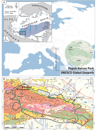
Figure 1. A) Location of the Papuk UNESCO Global Geopark. Upper left inset with simplified map of the Dinaride-Alpine-Pannonian region shows position of the mountain belts, Pannonian Basin and Tisia Mega-Unit (blue shaded area). The position of Slavonian Mts. is marked by blue rectangle. B) Simplified geological map of Croatia M 1:300.000 (Croatian Geological Survey, 2009) with positions of the key volcanic localities (Rupnica and Trešnjevica). Green line marks the border of Papuk Nature Park, while gray line marks the border of Papuk UNESCO Global Geopark. Legend: 1 – metamorphic rock complex (Precambrian); 2 – progressive metamorphic series (Ordovician-Devonian); 3 – metamorphic rock complex (Ordovician-Devonian); 4 – granitic rocks (Ordovician-Devonian); 8 – Variscan/Hercynian semi-metamorphic complex (Devonian-Permian); 13b – clastic sedimentary deposits (Late Permian); 14 – clastic sedimentary deposits and carbonates (Early Triassic); 15 – carbonate deposits (Middle Triassic); 44 – clastic sedimentary deposits and carbonates (Miocene, M2,3); 46 – “litavac” (bioclastic beech carbonate) and clastic sedimentary deposits with volcanic rocks (Miocene, M4); 47 – carbonate clastic deposits (Miocene, M5,6); 48 – clastic sedimentary rocks and coal (Miocene, M7); 50 – “Paludina beds” (freshwater deposits with Viviparus sp.) (Pliocene); 52 – clastic deposites (Plio-Quaternary); 54a – loess (Pleistocene); 58a – delluvial-proluvial deposits (Holocene); 58b – alluvial deposits (Holocene); α – andesites and rhyolites (Miocene, M3,4).
Among the numerous geological features of Mt. Papuk, which developed over a vast period of ~500 Ma from the Early Paleozoic (metamorphic rocks) to recent times (on-going formation of tufa rock), the (most) important part of the geological mosaic, at least in western parts, are the Late Cretaceous volcanic rocks (Schneider et al. 2022). Although volcanic rocks cover only a relatively small area in the western part of Mt. Papuk (~2 % of the surface area), their occurrence and petrogenetic characteristics are important for interpretation of the complex geodynamic evolution of this marginal part of the Pannonian Basin. The best exposures of the volcanic rocks are in the vicinity of the town of Voćin (northern slopes of Mt. Papuk; inset in Fig. 1) and are part of the larger volcanic body, Voćin volcanic mass, that covers a total of ~10 km2 (Pamić 1991, 1997). The Voćin volcanic mass (Pamić 1991) consists of basalts, andesites, rhyolites and pyroclastic rocks of Late Cretaceous age (~81 Ma for the Rupnica geosite, Schneider et al. 2022) that cross cut the Variscan basement rocks (Jamičić & Brkić 1986; Jamičić et al. 1987, 1989; Jamičić 1989; Pamić 1991, 1997). Although the rocks of the Voćin volcanic mass have limited surface exposure, their representatives (the best exposure of volcanic rocks in the Croatian part of the Pannonian Basin), rarity (columnar jointing phenomenon occurred in the acidic rock), integrity (well-preserved sites), scientific knowledge (scientific publications that emphasize Cretaceous age, high-T conditions, geochemistry corresponding to anorogenic magma, rapid uplift of magma from deeper crustal levels, transition from compressional to extensional tectonics) give an opportunity for reconstructions on a regional scale. That is to say, similar intense magmatic activity during the Late Cretaceous also occurred in the adjacent geotectonic unit called the Sava-Vardar Zone (Pamić 1993, 2002) or Sava Zone (Schmid et al. 2008, 2020), making the Cretaceous volcanic rocks of the western part of Mt. Papuk an important part of the still fragmented geological record of the geodynamic evolution in this region. Decades of geological research in the western part of Mt. Papuk have provided a solid scientific base for the reconstruction of its complex geologic evolution, highlighting the current scientific importance of the Papuk Geopark geological inventory.
The Cretaceous volcanic geosites easily accessible to the public in the Papuk UNESCO Global Geopark (Papuk UGGp) are the Rupnica and Trešnjevica, both former quarries abandoned in the last century. The volcanic phenomenon of columnar jointing at Mt. Papuk is unique in Croatia and its best exposure at the Rupnica geosite was declared the “First Croatian Geological Monument of Nature” as early as 1948 (https://www.bioportal.hr) making the Rupnica a key locality with national significance as the only protected exposure of this type in Croatia.
Papuk UNESCO Global Geopark and its Key Geosites
The area of Mt. Papuk is characterized by rich biodiversity and historical heritage, but also by exceptional geodiversity, providing the grounds for the declaration of the Papuk Nature Park (Papuk NP) in 1999, and defining Javna ustanova Park prirode Papuk (Public Institution Papuk Nature Park) as the institution that governs the park, covering an area of 336 km2 (Official Gazette of the Republic of Croatia, NN 45/99 and 96/99). In 2007, the geodiversity and geoheritage of Mt. Papuk were internationally recognized, making it the first protected area in Croatia to receive the status of a UGGp (the area extended to 524 km2) and it became a member of both the European and Global Geopark Networks under the auspices of UNESCO (Division of Earth Sciences).
From a geological point of view, Mt. Papuk is the most diverse mountain in Croatia. Geological diversity is represented by both geochronological diversity (rocks formed from the early Palaeozoic to the present) and lithological diversity (various sedimentary, metamorphic and igneous rocks). Igneous rocks of the Voćin volcanic mass are presented to the public in two out of 69 geosites of the Papuk UGGp – Rupnica and Trešnjevica. The main features of other geosites are related to tectonic, geomorphological, sedimentological, paleontological, stratigraphic and hydrogeological features (Public Institution Papuk Nature Park 2011).
The unique geological features of the Rupnica geosite, the most famous geologic symbol of the Papuk UGGp, were well exposed through mining, mainly related to the construction of railway and road infrastructure in the 19th and 20th centuries. The area of the former quarry on the northwestern flank of Mt. Papuk is easily accessible to visitors, and it is the aesthetic component that primarily attracts the visitors’ attention – the morphological feature of the columnar jointing of volcanic rocks, popularly called organ pipes. However, the presentation of the geosite as a locality where one can observe the effects of the “frozen” fiery forces of nature has promoted its geological significance to the public over the years, making it a landmark of the geological heritage of Papuk UGGp. The nearby abandoned Trešnjevica quarry is another geosite related to the same volcanic episode. Here a swarm of effusive rocks of basic to acidic composition is exposed, cross cutting the older igneous and metamorphic rocks.
Rupnica Geosite
The more or less regular prismatic fracturing of volcanic rocks into columns has been observed since ancient times and reported from many world-renowned localities. Such descriptions in the literature date back to the 17th century, reporting the Giant’s Causeway in Northern Ireland (Bulkeley 1693, cited in Tomkeieff 1940). Basaltic columnar jointing is common in Central Europe and superb exposures are known from Austria, Bohemia, Hungary, Poland, Romania, and Slovakia. Most of them form the core of geosites and protected areas, and some of them are even part of the UNESCO Global Geoparks Network, such as the Bakony-Balaton Geopark (Martin & Németh 2004) and the Novohrad-Nógrád Geopark (Hetenyi et al. 2012).
Although the exposure of columnar jointing at Rupnica geosite (Fig. 2) is not as impressive in size as the Giant’s Causeway or some other noted sites with the same feature (e.g., Devil’s Postpile; Columbia River Basalts, USA), it is a scientifically significant geosite because of the type of rock in which the columnar jointing developed. Generally, columnar jointing develops readily in less viscous basaltic magmas, as seen for example at the type locality of basalt, the Stolpen Castle Hill (recently corrected to be basanite to nephelinite), which shows basaltic columnar jointing (Tietz et al. 2018). However, columnar jointing is today known to develop in almost all rock types including welded ignimbrites (Ahn 2018, Lebti et al. 2006), and in various geological environments, including even glaciovolcanic (Tuffen et al. 2001) and subaqueous conditions (Mueller & Donaldson 1992).
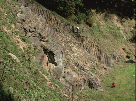
Figure 2. Panoramic view of the Rupnica geosite. The polygonal columnar pattern developed in the albite rhyolite at Rupnica geosite. The person in the bottom right as a scale.
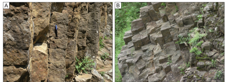
Figure 3. The columnar jointing developed at the Rupnica geosite. A) Columns - side view with propagating cracks and striae. A pen as a scale. B) Polygonal columnar pattern visible at Rupnica geosite, dominated by four-sided columns.
The rocks exposed at the Rupnica are acidic and classify as albite and aegirine-albite rhyolites (Tajder 1956, 1960). The geodynamics of the origin and emplacement of acidic rocks in the western area of Mt. Papuk (e.g., Balen & Petrinec 2014, Schneider et al. 2022) place the Rupnica geosite alongside the best columnar rhyolitic rock formations in the world, such as the Early Cretaceous High Island Formation of the Hong Kong UNESCO Global Geopark (Zhao et al. 2017).
The rocks of Rupnica have a porphyritic texture dominated by albite phenocrysts hosted in a matrix of albite microliths, quartz and devitrified volcanic glass. Accessory minerals include magnetite, apatite, zircon and occasionally alkali clinopyroxene (aegirine, aegirine-augite). The development of columnar jointing in these rocks, as well as the morphometric characteristics of the columns, were studied by Balen & Petrinec (2014) using a statistical evaluation of crack counting in which numerous geology and environmental science students participated. The research revealed that relatively narrow, predominantly four- and five-sided columns, tightly packed striae, and small amplitude wavy sets of columns dominate the exposed part (Figs. 2 and 3). Features quantified through the statistical approach, together with petrography, geochemistry, and geology of the geosite surroundings, provided information about the speed of cooling and depth of the (sub)surface acidic volcanic body. Columnar jointing developed under the combined influence of large-scale supercooling and thermal contraction. This analysis at Rupnica and at the nearby localities of Omerovac, Jovanovica and Turski grad (our unpublished data), reveals the operation of the “T-junction” formation mechanism that produced predominantly four-sided columns (Fig. 3), indicating rapid cooling at low pressure, with a near-surface crustal level of emplacement of the subvolcanic body (Balen et al. 2010; Balen 2011; Balen & Petrinec 2014).
Additional geochemical and mineralogical studies revealed that the melt originating from mid- to-lower-crustal depths reached the shallow emplacement level as a high-temperature magma (780–900 °C). The source of the parental A-type magma is related to the lower crust in an anorogenic tectonic setting with peraluminous, alkali-calcic to alkalic and ferroan character (Balen et al. 2020; Schneider et al. 2022). Recent studies of inclusions captured in accessory zircon (i.e., anatase, fluorapatite and hematite) indicate crustal source contribution, rapid uplift and cooling of an oxidized magma (Schneider & Balen 2022; Schneider et al. 2022). Igneous rocks, now exposed at the Rupnica geosite, formed by cooling and (near) surface crystallization of acidic magma during the Late Cretaceous (~81 Ma, Schneider et al. 2022), related to the closure of the Neotethys Ocean.
Trešnjevica Geosite
Although Mt. Papuk crystalline is mostly composed of pre-Alpine metamorphic and igneous rocks, at the Trešnjevica geosite, where the pre-Alpine gneisses and granitoid rocks are exposed, swarms of younger igneous rocks can be found (Fig. 4). They crosscut the igneous rocks of the older complex and each other. Many varieties of volcanic rocks are found here, including various subtypes of rhyolite, andesite, basalt, metabasalt, dolerite (“diabase”), as well as pyroclastic rocks and volcanic breccia. The rocks of older complexes, such as granite, pegmatite, gneiss and migmatite, are present at this geosite as well. Geological relationships are clearly visible and the site thus provides an opportunity to study the different types of igneous rocks, their mineralogy, textures, modes of occurrence, and their original geological setting based on geochemical data (Balen et al. 2009).
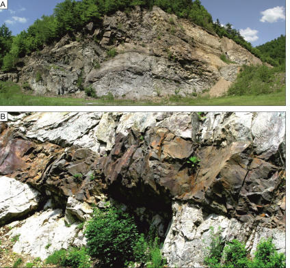
Figure 4. Trešnjevica geosite. A) Panoramic view of the dyke swarm. B) Details of the dyke penetrating the light-coloured rocks of the Variscan igneous and metamorphic complex. Thickness of the dyke ~1 m.
The dominant igneous rock in the dykes on this geosite is rhyolite, which does not differ significantly from that at the Rupnica geosite. The rhyolite varieties include albite, anorthoclase, and aegirine-albite rhyolite (Tajder 1956, 1960). Other varieties of dyke rocks include andesite which is a dark-gray compact rock (Kišpatić 1887, 1916; Tajder, 1956). Dark igneous rock is also basalt with phenocrysts of feldspars (labradorite) up to 4-7 mm in size that can be found in the holocrystalline matrix together with clinopyroxene (augite), while minerals in the matrix include submillimeter grains of plagioclase, pyroxene, magnetite, ilmenite, apatite and secondary chlorite and calcite. The basalts are porphyritic to ophitic in texture. Besides fresh basalts, there are also altered varieties (metabasalts, Pamić 1991), the latter being more common. The texture of the metabasalts is homogeneous and contains up to 20 vol. % of amygdales filled with calcite, chlorite, pumpellyite and with minor prehnite, quartz and zeolite. Pyroclastic rocks, including coarse-grained varieties and tuffs, cover roughly the same area as effusive rocks (Jamičić et al. 1987; Pamić 1991). The pyroclastic rocks contain basaltic and rhyolitic clasts. Tuffs have a massive texture and comprise basalt lithoclasts, with thicknesses varying from the cm- to deca-meter thick intercalations inside pyroclastic rocks. Lithoclasts of basalt, crystaloclasts of feldspars and clinopyroxene are found inside the tuff, while devitrified volcanic glass is usually present in the matrix. Tuffs are classified as lithoclastic to vitroclastic (Pamić 1991).
The igneous rocks of the Voćin volcanic mass show transitional affinity, ranging from sub-alkaline to alkaline (Fig. 5A). Incompatible trace elements, trace element ratios, and apparent enrichment of light rare earth elements (REE) together with a moderate to low abundance of high field strength elements, a variable abundance of large ion lithophile elements and a negative europium anomaly for acidic varieties, suggest melting of mid- to low-crust material. The distribution of REE in the studied samples (Fig. 5B) supports this conclusion. The high magmatic temperatures are in accordance with the inferred within-plate and volcanic arc tectonic setting. The preliminary age dating of zircon from albite rhyolite using the LA-ICP-MS method revealed a Late Cretaceous age (our unpublished data) and corresponds well with the age determined for albite rhyolite from Rupnica (~81 Ma) and the regional thermal event (Balen et al. 2020, Schneider et al. 2022). The age of the albite rhyolite of Mt. Papuk is coeval with geochemically similar igneous rocks from Mt. Požeška Gora (Balen et al. 2020), Mt. Prosara and Mt. Kozara (Ustaszewski et al. 2009, 2010; Cvetković et al. 2014), which are situated within an important Cretaceous suture zone (Sava Zone) after the closure of Neotethys Ocean. These indicate similar and contemporaneous geological processes that occurred in a long collisional zone between the ancient margins of Europe and Africa.
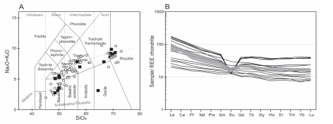
Figure 5. A) TAS diagram (Le Bas et al. 1986) illustrating geochemical variation of the Voćin volcanic rocks. Circles represent analyses from the literature (Tajder 1956, 1960; Lugović 1983; Jamičić et al. 1987; Pamić 1991, 1997), while our data are represented by squares for Trešnjevica geosite and triangles for Rupnica geosite. B) Spider-diagram of rare-earth element abundances normalized on chondrite after Boynton (1984). Gray shaded pattern for Rupnica geosite, black patterns for Trešnjevica geosite.
Host Rocks of the Cretaceous Volcanic Rocks: Voćin – Zvečevo – Kamenska Section
Although Cretaceous volcanic rocks are the exclusive feature of the western part of Mt. Papuk, significantly older rocks of the Variscan orogenic cycle were recognized early as the most widespread and represent a well-documented geodynamic episode in the area (Pamić & Lanphere 1991). The Variscan rocks are related to geological processes that occurred in the deeper crustal levels, tens of kilometers deep. The origin of these rocks thus differs in terms of age and geological processes from the Cretaceous igneous rocks from the Rupnica and Trešnjevica geosites.
Outcrops of Variscan granite, migmatite and gneiss can be found along the road Voćin–Zvečevo–Kamenska. At the Čarugin Kamen geosite, partially melted crustal rocks (migmatites) with typical zebra-like textures are exposed together with gneisses. Near the geosite, a wide variety of rock textures and structures are observable relating to variation in the volume content of key mineral constituents (feldspar, quartz and mica). Granite with its igneous structures forms large irregular bodies that are also present within the gneiss-migmatite zone, although they are extensively tectonically disturbed and fragmented. They are characterized by a massive texture (visible at the Zvečevo Potočan geosite) and the mineral assemblage of quartz, feldspar (albite and microcline) with micas (biotite, muscovite). Complex geological relations among various rock types in the western Papuk area are presented on the informative panel at the geo-information point at the Zvečevo site (Fig. 6).
Linking Geoheritahge to Geoeducation, Geotourism and Geoconservation
The basic document of the Papuk NP was the Management Plan of the Papuk Nature Park (Public Institution Papuk Nature Park 2011) that, among others, set aims and activities for protection and preservation of geological and geomorphological diversity and visiting, recreation, education and the marketing of the destination. However, the Study of the management of the number of visitors with an action plan for the management of visits in the Papuk Nature Park (2020–2029) (Public Institution Papuk Nature Park 2020) was published as a part of the project Geo Stories of the UNESCO Geopark. The document contains descriptive and analytical parts related to visits to the Papuk NP and a visitor management plan with detailed analysis of the structure and the number of visitors, visitor monitoring, visitor and interpretation infrastructure, educational and recreation programs, communication and cooperation, together with capacities for visitor management. According to this document, geotouristic development of the western area of Mt. Papuk is planned through 2020–2029, following the establishment of the Geo-info Center in Voćin. Initial visitor numbers to the Geo-info Center in 2022 (18,500 visitors) speak in favor of such predictions.
Besides the scientific value of the previously described key volcanic sites of the Papuk UGGp, the Rupnica geosite attracts the attention of visitors primarily by its aesthetic value and is therefore an important landmark that contributes to local tourism. The Rupnica geosite is also an important example of the successful revitalization and presentation of mining heritage in the Republic of Croatia as it relates industrial (mining) and natural (geological) heritage. The research conducted by Briševac et al. (2021) at four Croatian geoheritage sites (including Rupnica) indicated strong and weak points of the revitalization of the geoheritage sites, as well as future opportunities and possible threats to which the natural heritage like Rupnica’s columnar jointing might be exposed. According to the authors, local authorities in cooperation with local tourist offices have crucial roles in the preservation and management of geological heritage, largely assisted by European funding.
Rupnica is a prime example of how the application of geologically informative principles of geotourism (Dowling 2011) can be a driving force in its development. Education about basic earth science principles and their interpretation at the geosite has recently been upgraded by the opening of the Geo-info Center at Voćin, providing the opportunity for visitors to develop their knowledge about natural processes and awareness about the need for protection and management of natural and historic heritage of the region and the role they may take in it. There is a short education trail on the site with four explanatory educational panels showing different types of volcanos with a general description of volcanic rocks and processes, and three viewing platforms for observing the jointing phenomenon from different perspectives. One of the panels is dedicated to the columnar jointing developed at the site and includes a short note about the history of protection of the site. A guided tour around the Rupnica geosite is an optional feature of some of the educational programs. The geosite is located on the road leading along the Western geological profile and is easily accessible by car or bus. A few kilometers further on is the Trešnjevica geosite with three explanatory education panels about the geological significance of this site and a simple experimental setup simulating a volcanic eruption through the classical chemical reaction between an acid and a carbonate.
The area around the Zvečevo locality was one of the most visited excursion zones on Mt. Papuk, with the most significant accommodation facilities in the area. However, it lost its role as a base from which to visit Papuk after the devastation during the Croatian War of Independence in the 1990s. The site is known for its important biodiversity, with rare wet grassland areas, home to an endangered marsh butterfly. In the immediate vicinity of this grassland, the geo-information point Zvečevo displays a panel showing a simplified cross-section through the Western geological profile (Fig. 6).
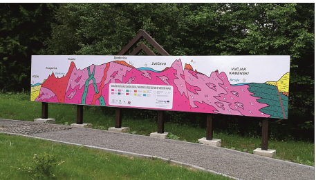
Figure 6. Geo-information point Zvečevo by the Voćin – Kamenska road (Western geological profile) with characteristic geological section through igneous, volcanic and metamorphic rocks of the area. Left-hand side of profile shows Voćin volcanic mass.
Although the Cretaceous volcanic occurrences near Voćin and the section through the oldest rock formations of the western part of Mt. Papuk attract more visitors each year and the presentation of the geo-educational content has improved, significant touristic infrastructure is still lacking in the area. The opening of the modern Geo-info Center in Voćin in 2022 may thus represent a turning point towards the development of sustainable tourism in the western part of the Papuk UGGp.
Geo-info Center Voćin
In early 2022, a visitor center (Fig. 7) was opened in the town of Voćin, about 1 km from the Rupnica geosite. It is the main presentation center of the Papuk UGGp. In addition to basic information about Papuk NP, the new Geo-info Center offers educational resources in the fields of geology, seismology, biology and archaeology, all based on scientific research. The educational content presented at the center is highly interactive and takes advantage of modern multimedia technology. From the main entrance, visitors are directed to the interactive panels (touch screens) that cover a variety of geodiversity topics relating to the UNESCO Global Geopark Network. The next theme is presented in a cinema that simulates a journey through the geological evolution of the present Papuk area. Visitors can then explore the large hall with Origin of Life, Wall of Evolution and Solar system exhibitions, along with a round table with a relief and an interactive geological map of Mt. Papuk with rock samples, additional interactive panels, the earthquake table and the Earth globe. On the upper floor, biological, archeological and geological collections are presented, together with a small workshop/laboratory and interactive rooms covering bio- and geo-diversity of the area.
There is also specific content dedicated to the geology of the nearby Rupnica and Trešnjevica geosites. From a small café-restaurant in the Geo-info Center, one can enjoy the view of the medieval fortress above Voćin (Turski grad fortress), built on a volcanic hill above the confluence of the Jovanovica and Voćinska Rijeka rivers, which cut through the Voćin volcanic mass revealing numerous smaller outcrops of volcanic rocks near the Geo-info Center, such as Jovanovica geosite. The building of the Geo-info Center is designed so that its external towers resemble the four-sided columns of the Rupnica (Fig. 7).
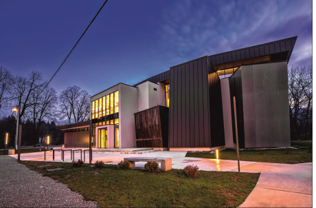
Figure 7. Geo-info Centre Voćin. The towers on the right-hand side of the photo symbolically represent Rupnica geosite columns. (Photo: K. Toplak)
The Geo-info Center Voćin was built as a part of the project Geo Stories of the UNESCO Geopark (https://geoinfocentar.com/geo-price-unesco-geoparka/) that was co-financed from the Operational Program Competitiveness and Cohesion 2014–2020, submitted to the call for Promotion of sustainable use of nature heritage in national parks and nature parks of the Ministry of Regional Development and European Union Funds. The project goals were aimed at the development of touristic potential in the continental part of Croatia, including improvement in tourist infrastructure and visitor management system of the Papuk NP as a part of promoting sustainable socio-economic development. The project holder was the Public Institution Papuk Nature Park, and the project partner was the County Road Administration of the Virovitica-Podravina County.
Educational Programme Rupko’s Geological School
The Rupnica and Trešnjevica geosites are valuable resources for introducing the public to geology. They illustrate the diverse and interesting geology of the Papuk UGGp with special attention devoted to the volcanic phenomena. In addition, these sites are also used as educational sites for both higher education students and schoolchildren. The remarkable example of the variability of volcanic rocks and processes is explained with educational panels on site and with Rupko’s Geological School educational content at both geosites. Rupko’s Geological School is a Papuk UGGp programme that teaches primary school children the basic concepts of geology using examples from the Papuk area. Papuk UGGp tours are available on request and are conducted by trained guides. As part of the same programme, a geological guide for children has been published in Croatian and English to accompany the geological education content.
Simulation of Columnar Jointing Process (Starch-Water Experiment)
The more or less regular prismatic fracturing of volcanic rocks into columns at the Rupnica geosite and many more famous localities is a universal natural feature. In fact, columnar jointing is not restricted to volcanic rocks, but also develops in other materials. The science that describes the behavior of different materials is reflected in the various branches of physics, materials science, cryoscience and even planetary science (e.g., Budkewitsch & Robin 1994, Goehring 2013).
The Geo-info Center Voćin hosts a small workshop as part of Rupko’s Geological School programme, in which a simple experiment is performed, simulating the development of columnar jointing using non-expensive and everyday ingredients (i.e., water and starch). The regularity behind the processes can be demonstrated and the scientific facts behind the phenomenon of columnar jointing (Toramaru & Matsumoto 2004) can be easily communicated to students through an experiment with a starch-water mixture (i.e., drying a starch-water slurry or cake in a glass jar). The experiment (Fig. 8A) is easily conducted using an ordinary lightbulb as a heating device. Natural processes in the cooling of the silicate melt can be represented by variations in the speed of drying of the starch-water slurry, leading to the development of different types of junctions (Fig. 8B). A faster starch-water mixture drying rate (equivalent to the cooling rate in the melt) causes cracking of the mass with prevailing T-junctions (Fig. 8C). Such cracks run almost perpendicular to each other and form a more or less regular rectangular network. In 3D, the cracks extend from the surface into the depth of the material and form four-sided columns at the base of the experimental volume. On the other hand, a slower drying rate will induce Y-junctions where the cracks form a six-sided pattern and six-sided columns are formed in the starch experiment (Fig. 8C). This regularity can be extended to the silicate melt (Budkewitsch & Robin 1994, Goehring & Morris 2005, 2008; Goehring et al. 2006, 2009; Jagla & Rojo 2002; Weinberger 2001; Calderón & Sánchez 2023), which cools faster (favoring T-junctions) or slower (producing more Y-junctions).
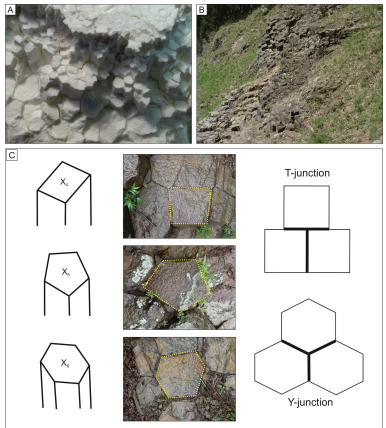
Figure 8. A) Columnar jointing experiment at the Rupko’s Geological School using starch-water slurry. B) Comparison with a real volcanic rock outcrop at Rupnica. C) Sketch of four-, five- and six-sided columns with real examples at Rupnica geosite and sketch of T- and Y-junctions.
Statistical evaluation of columnar jointing at the Rupnica geosite (Balen & Petrinec 2014) provides the basis for interpreting the observed and measured cracking phenomena, according to the theory of rapid melt uplift and cooling. Most commonly observed are T-junctions and four-sided columns (Figs. 3B and 8B). This simple experimental setup thus provides an excellent example of a large-scale natural phenomenon developed at the nearby Rupnica geosite but also at Trešnjevica geosite.
Summary
The main tasks of a geopark are geoconservation with geoheritage protection, geoeducation and geotourism. Such tasks and related activities in the Papuk UGGp are performed in close collaboration with the local community, government offices (Ministry of Economy and Sustainable Development), European and Global Geopark Networks but also with scientific community. The development of infrastructure and increased availability of information about 69 documented geosites, as well as educational trails, numerous workshops, educational programs and facilities at geo-info centers are all in progress in the Papuk UGGp area. The Geo-info Center Voćin opened in 2022 has improved the educational offer. A key part of the geological mosaic, at least in the western parts of Papuk UGGp, is the Cretaceous volcanic area of the Voćin volcanic mass, representing a fundamental part of the geopark and its geodiversity with Rupnica and Trešnjevica as key geosites.
The acidic silicate melts of the Voćin volcanic mass in the Papuk UGGp originated from mid- to-lower-crustal depths and reached a shallow emplacement level as a high temperature (up to 900 °C) magma. Geochemistry points to a parental A-type magma formed in an anorogenic tectonic setting. Studies of accessory minerals such as zircon and apatite, as well as studies of mineral inclusions captured in accessory zircon (i.e., anatase, fluorapatite and hematite) indicate possible contributions from deeper crustal levels, fast uplift and cooling of magma. The volcanic rocks were formed in the Late Cretaceous (~81 Ma) through cooling at low pressure, i.e., a shallow position within the igneous body. The relatively fast cooling rate caused the development of T-junctions in the columnar jointing process. This resulted in predominantly four-sided columns that are well exposed at Rupnica geosite.
The Papuk UGGp systematically encourages research activities by providing logistical support in the field, as well as modest financial support under its own funding program. Systematic collection of scientific data over decades and constant valorization of the geoheritage, the efforts of the Papuk UGGp staff and the accompanying scientists are rewarded through the development and enhancement of geoeducation, geotourism and geoconservation efforts of the area as well as with the international recognition.
Conflict of Interest
None