Introduction
The development of drilling technology revolutionized our understanding of the sub-surface and massively enhanced our ability to exploit geological resources. Drilling boreholes to exploit brine and natural gas has a long history and was being undertaken in the Sichuan province of China from the 3rd century AD. Boreholes up to 140 m were being drilled using iron bits and bamboo poles (Kuhn 2004). A complex industry developed utilizing the incredible strength and resilience of bamboo enabling depths of up to 400m being reached by the 1700s and the first 1000m deep well being drilled in 1835 (Travel China Guide undated). At this time in Euro-North American western cultures, while borehole drilling was an established industry for water and other resources, the maximum depths achieved were around 500m. By the 1850s rotary drilling was becoming more common in North America and Europe for oil, gas and water. Prior to this boreholes were drilled using either percussive techniques or variations on auger designs for shallower depths. John Vivian was given the first U.S. patent for a diamond drill in 1876. This development enabled the recovery of an intact core so was very valuable for prospectors and their successors – geologists (The Driller undated).
A century and a half later the recovery of a drill core is still the best way to directly sample the rock units being penetrated. Today a whole suite of geophysical measurement tools can be used to measure properties of the borehole walls but recovering a drill core remains the only way to get direct measurements of a range of rock properties. While in today’s geoscience these other techniques have gone some way to reducing the value, and have certainly reduced the frequency and thus associated risks, of cutting a core (Williams 2021) the study of recovered and preserved cores remains pivotal to modern geological studies. The relatively recent application of core drilling technology on ice bodies has gone on to revolutionize palaeoclimate studies (National Science Foundation undated).
In geoscience education it is the exception rather than the norm if core samples are used at all in practical or field based education. This is in direct contradiction to professional practice where the vast majority of geo-material samples the students will work on once they have graduated will be borehole cores. In the commercial world geological samples are nearly always cylindrical, of limited volume and are not the imposing cliff, mountain or foreshore exposures studied during educational field trips. This mismatch between education and practice in the geosciences is being actively addressed by North Sea Core, a community interest company set up in response to the release of core material by energy companies through the relinquishment, abandonment and decommissioning of hydrocarbon fields on the UK Continental Shelf. They recognize that the core material provides an incredible resource for understanding the subsurface and is invaluable to geologists. Rather than seeing this important part of our offshore geoheritage be discarded, they collect and redistribute core material for use by the geological and wider scientific community worldwide (North Sea Core undated).
In the United Kingdom there are statutory requirements for centrally recording any boreholes drilled to a depth of greater than 30m for minerals and 15m for water resources (Casserly 2012, UK Government undated). though there is no such requirement for those drilled for civil engineering purposes. Information including geological logs has been collected and maintained centrally since the 1950s with sporadic earlier records dating from the 1880s (British Geological Survey undated). Part of this data collection program includes core samples when deemed appropriate. It is estimated that as many as 20,000 boreholes are drilled annually in the UK and, even with the statutory requirements in place, the British Geological Survey estimates 80% of boreholes are unrecorded (Holger et al. 2018). If all this data were captured and made accessible then it could create significant cost and efficiency savings as well as helping to better constrain ground models.
While the importance of drill cores is appreciated across the scientific and industrial communities and their industry and governmental sponsors, there is little understanding of this value amongst the general public. This is perhaps something the geoscience community needs to address as there are significant costs associated with the preservation of these vital sources of information and, as public budgets come under ever increasing scrutiny, ensuring people are aware of how valuable core samples are may help justify the costs involved. So what could be done to bring the existence and importance of borehole cores to the attention of the wiser populace?
The only example of a borehole core on outdoor permanent public display in England known to the author is of a borehole which was important in the historical development of Barnoldswick, a small market town in the county of Lancashire, northern England. The town is surrounded by the Pennine hills and sits astride the national watershed between the valley of the River Ribble (draining westward) and the valley of the River Aire (draining eastward). The arrival of the Leeds and Liverpool Canal in the 1790s followed by the (now closed) railway in 1871 encouraged the development of an existing textile industry and Barnoldswick developed into a major cotton weaving town (Fig. 1). Prior to 1895 there was no adequate water supply – people relied on town wells or bought water from local carriers. Some houses had rain tanks in the cellar which stored water off the roof and a pump in the kitchen (Graham 1988). A reliable source was needed but the underlying geology was not conducive to groundwater abstraction.
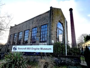
Figure 1. The architecturally impressive steam engine house of the demolished Bancroft’s Textile Mill, now preserved as a museum, gives an indication of the historic importance of Barnoldswick in the textile industry. The preserved chimney is 135 feet high.
Northern English industrial towns at the time often relied on borehole abstraction form the sandstones of the Carboniferous age Millstone Grit Group, the nearest outcrop of which forms the high ground of Weets Hill to the south east of the town. Land was purchased at Whitemoor on the flanks of Weets Hill in 1890 and work began. At first a 10 foot diameter well was dug to a depth of 105 feet. The yield from this well proved disappointing so in 1898 a 10 inch diameter borehole was drilled from the base of the well to a depth of 504 feet. Pumping tests proved a better yield from the well even though there was a drought ongoing at the time. The waterworks were officially opened in 1892 but demand soon outstripped supply and a further borehole was commissioned (Carthy & Lancaster 1990).
The new borehole was drilled to a depth of 922 feet with a diameter of 18 inches at the top and 14 inches at the base. The borehole was cased to a depth of 396ft. The new deeper borehole was only 20 metres to the west of the original borehole site and its yield proved disappointing. An investigation was undertaken into the geological controls on water supply by Professor Percy Kendall of Leeds University who was a leading figure in the development of geology in the north of England (Rowe undated, Versey 1937). The results of Professor Kendall’s investigations were that little further resource would be gained from further engineering works at the site due to unfavourable geological conditions. These conclusions were presented to the UK parliament in support of a bill seeking approval to construct a surface water reservoir for the town to supplement the borehole supplies.
While the borehole proved less than fully successful as a water supply part of the recovered core has been preserved in Letcliffe Park, a recreation area established by the local government in 1902. The core is in pieces which are scattered around the formalized garden section of the park and form an intrinsic part of this designed and engineered outdoor recreational landscape. The longest section forms a 7 m long path edge and all are of 16 ½ inch diameter so consistent with an 18 inch borehole diameter (Fig.2). Other pieces are scattered through the park forming gateway edges and wall tops amongst other things. The various segments are not in any order or consistent orientation but four segments have depths carved into them – 630, 669, 702 and 780 feet. The orientation of the carvings show sections are not in order and at least one piece is inverted. All the four recorded depths are assigned to units named ‘Grit’ or ‘Grit with shale joints’ on the borehole log (Britsh Geological Survey undated). The presence of the core is not mentioned on the on-site noticeboards giving a history of the park and no explanatory material has been located. This is a real a shame as an opportunity to bring the importance of geological cores to the public’s attention is sadly being missed. They are important cultural aspects of the areas geoheritage with as yet untapped educational potential. However, a piece of the core is now incorporated into the Barnoldswick sensory garden which is a recent (2018) addition to the Barnoldswick Forces Memorial garden closer to the town center (Fig.3). This does have some very limited explanatory material which refers the historical quarrying of sandstone locally but no mention of its role in the development of the town’s water supply.
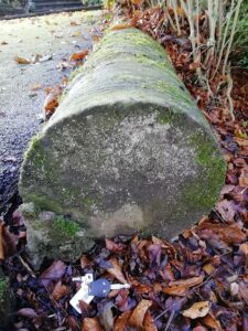
Figure 2. Sections of the Barnoldswick Waterworks Borehole core being utilized as path edging in the Letcliffe Park recreation area.
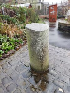
Figure 3. A section of the Barnoldswick Waterworks Borehole core now incorporated into the towns sensory
The preserved core in Barnoldswick is the only example the author is aware of where a core has been deliberately placed on public display outdoors. The lack of a reliable water supply was a big issue for Barnoldswick so maybe the core was considered too valuable to simply dispose of at the time but the lack of accompanying explanatory information is an opportunity missed. There are various museums and memorials associated with boreholes in England such as the Dukes Wood Oil Museum in Nottinghamshire (Dukes Wood Oil Museum undated). There is a memorial statue, named the Oil Patch Warrior, to the American drillers who ran a secret oil drilling campaign in the oilfields of the English midlands during the Second World War at Rufford Abbey Country Park near Newark (Atlas Obscura undated) but no other example of core being on public display is known. Looking further afield the geoscience and environmental education center in Windeschesenschenbach, Bavaria, has the core samples from the German Continental Deep Drilling project for educational use. This is widely known as the KTB borehole which was drilled to a depth of 9,101 m between 1987 and 1995 (GEo-center at the KTB undated) as a cold war rival to the Kola superdeep borehole, still the world’s deepest borehole, drilled by the Soviet Union.
Considering the importance of borehole cores to our understanding of the sub-surface and the need to raise the profile of the geosciences to ensure governments and the public understand how they underpin our society, perhaps it is time we did more than just preserve these incredibly important data sources in a core store. We need to come up with innovative ways of bringing their existence and both scientific and economic importance to public attention. Going forward we need to ensure the importance of cutting and preserving borehole cores is understood outside our own community and their educational potential is fully realized.
References
Atlas Obscura undated. The Oil Patch Warrior, Newark, England. https://www.atlasobscura.com/ places/the-oil-patch-warrior .Retrieved November 12, 2021
British Geological Survey (undated). National Data Repository. https://www.bgs.ac.uk/geological-data/ national-geological-repository/.Retrieved Novem ber 10, 2021
Carthy D and Lancaster M (1990). West Craven Patch work. Privately published, Barnoldswick.
Casserly AM (2012). AGS (Association of Geotechni cal and Geoenvironmental Specialists). Legal ob ligations regarding drilling. https://www.ags.org. uk/2012/09/bgs-question-and-answer/ .Retrieved November 12, 2021
The Driller (undated). Drilling Through History. https:// www.thedriller.com/drilling-history. Retrieved No vember 7, 2021.
Dukes Wood Oil Museum (undated). Dukes Wood (dukeswoodoilmuseum.com). Retrieved November 12, 2021.
GEo-center at the KTB (undated) https://www.geozen trum-ktb.de/ . Retrieved November 12, 2021. Graham SC (1988). Barnoldswick the story of a Pen nine town. Privately published, Barnoldswick.
Holger K, Marchant M, Roper S, Fernie A and Payne S (2018). British Drilling Association: Accessing the UKs borehole data.https://www.britishdrillingasso ciation.co.uk/news/accessing-the-uks-borehole-da ta/ .Retrieved November 12, 2021. Kuhn O (2004). Ancient Chinese Drilling. Record er. 29(6). https://csegrecorder.com/articles/view/ ancient-chinese-drilling .Retrieved November 7, 2021.
Kuhn O (2004). Ancient Chinese Drilling. Record er. 29(6). https://csegrecorder.com/articles/view/ ancient-chinese-drilling .Retrieved November 7, 2021
National Science Foundation (undated). Ice Core Facil ity. https://icecores.org/about-ice-cores . Retrieved 10 February, 2022.
North Sea Core (undated). www.northseacore.co.uk. Retrieved 8 February, 2020
Rowe D (undated). Percy Fry Kendall. Yorkshire Philo sophical Society https://www.ypsyork.org/resourc es/yorkshire-scientists-and-innovators/kendall/ Retrieved November 12, 2021.
Travel China Guide (undated). Salt Industry History Museum. Zigong Salt History Museum, Sichuan (travelchinaguide.com). Retrieved January 12, 2022.
UK Government Borehole Notifications (undated). https://data.gov.uk/dataset/56385430-01cc-436b-9d28 ce77771faf7f/borehole-notification . Retrieved No vember 12, 2021.
Versey HC (1937). In memoriam: Percy Fry Kendall. Proceedings of the Yorkshire Geological Society. 23(4): 196-198.
Williams L (2021).Have we passed peak core? Geosci entist September 2021. https://geoscientist.online/ sections/unearthed/have-we-passed-peak-core/.Re trieved November 7, 2021.