Introduction
Nature is an essential public good that provides resources and services indispensable for human life and wildlife, such as food, clean water, energy and mineral resources and shelter, which are referred to as Ecosystem Services (ES). In the context of environmental changes and the exploitation of natural resources, it is necessary to understand and manage these ESs, which benefit humanity, as well as conserve the resources and natural processes that produce them (Costanza et al. 1997; de Groot et al. 2010; Fox et al. 2020). In addition, natural ecosystems provide humanity with spiritual, recreational and educational benefits (MEA 2005) and perform crucial functions that balance the planet. ES has a direct relationship with the quality of life of people, influencing everything from the use of mineral raw materials in civil construction to the prevention of natural disasters and the maintenance of ecosystems. The use of these natural resources can generate economic value, for example, in activities such as mining, agriculture, tourism, and forestry.
Some classifications based on the ES concept are found in the literature, and of these, the UN Millennium Ecosystem Assessment (MEA 2005) is one of the most accepted and used. The concept of “Nature's Contributions to People” (NCP) was adopted by the UN’s Intergovernmental Platform on Biodiversity and Ecosystem Services (IPBES) (Díaz et al. 2018). The term refers to all the positive contributions, or benefits and, occasionally, negative contributions or losses, that people derive from nature and incorporates the multiple cultural and social aspects of the different peoples of the world, being an alternative to the mercantilist view of the expression “ecosystem services”.
ES results from the relationship between geodiversity and biodiversity (Gordon et al. 2012; Gray et al. 2012; Prosser et al. 2013; Alahuhta et al. 2018). These authors establish that the success of ecosystems critically depends on ES, as they constitute the fundamental connections between geodiversity, biodiversity and landscape, that is, between the geosphere and the biosphere. Geodiversity is defined by several authors who recognize it as a fundamental element of terrestrial and coastal ecosystems, having a direct impact on biodiversity and the quality of life of human communities (Brilha 2004, 2005; Gray 2004; Kozłowski 2004; Carcavilla-Urqui et al. 2008; Panizza and Piacente 2008).
Nevertheless, the contributions provided by nonliving (abiotic) elements of ecosystems are often neglected in the classification systems of ES (Van der Meulen et al. 2016; Van Ree and Van Beukering 2016; Queiroz and Garcia 2022). Ecosystems are not independent of their abiotic nature (biophysical structures and processes) or their geodiversity, and the boundary between abiotic and biotic services is usually undefined (Fox et al. 2020). In this context, Gray (2012, 2013, 2018), Gray et al. (2013) and Van Ree and Van Beukering (2016) define abiotic ES as the contribution of geological resources to human well-being and ecosystem functioning as an important relationship between biotic and abiotic resources. The conservation of geodiversity is then essential for the maintenance of ES and sustainable development (Gordon and Barron 2013), but this relationship is still poorly understood regarding environmental planning and management actions (Pereira 2010).
In the Amazon environment, rural communities are formed by peoples/populations whose mode of social organization is recognized as traditional (Lira and Chaves 2016). These communities have a way of life that is directly linked to the dynamics of nature, especially in areas surrounding protected areas (PAs), such as the banks of the low Negro River and the national parks (NPs) of Jaú and Anavilhanas, the focus of this study. Close to the park boundaries, there are more than 50 riverside communities that maintain their traditional ways of life, offering opportunities for contact with local culture and community-based tourism experiences.
However, despite this abundance, traditional Amazonian communities do not benefit satisfactorily from them. As Reis (1997) explains in the book “The rubber plantation and the rubber tapper”, “Although the Amazon has provided the world with elements of material and spiritual well-being, these conditions do not exist for the Amazonian populations themselves”. It is noteworthy that the largest Amazon cities have the worst human development indices (average HDI 0.61) and per capita income in Brazil (R$ 23 thousand) (FIRJAN 2020) and 10.4 million people suffer from poorly treated water (Instituto Trata Brasil 2022), even though it is in the largest watershed in the world.
On the bases of these aspects, this study aims to identify and analyze the ecosystem contributions provided by geodiversity in the low Rio Negro region, emphasizing the role of these aspects to the well-being of the Amazonian populations in the area.
Study Area
The Amazon Basin is approximately 7 million km2 in length, of which about 4 million km2 are in Brazilian territory (Fig. 1). The largest tributary of this basin is the Rio Negro (Filizola et al. 2002), where this research was conducted, more precisely in its lower course, which ranges from the municipality of Novo Airão to the state capital, Manaus (Fig. 2). The Rio Negro is a large and complex multichannel river with annual variability in the water level in its lower course reaching 10 m, with a flood period of more than seven months. The Anavilhanas Archipelago is the most prominent geomorphological feature of the area, with hundreds of islands and floodplain lakes (Marinho 2021).
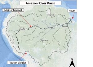
Figure 1. Map of the Amazon River basin that has the Rio Negro as its main tributary. Source: Marinho, 2021.
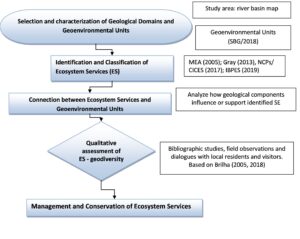
Figure 2. Location map of the municipalities belonging to the lower Rio Negro basin (AM).
The headwaters of the Rio Negro are located in the pre-Andean region of Colombia. A little farther down, starting in the Morichal Nuevo region, the river is renamed the Negro. The river flows eastwards, where it marks the border between Colombia and Venezuela until it enters Brazilian territory at São Gabriel da Cachoeira (AM). Within Brazil, the river flows in a southeast direction until its mouth enters the Amazon River, with a total length of 1,700 km, at a place called the “Meeting of the Waters”, where its dark waters meet the muddy waters of the Solimões River, and the river becomes the Amazon (Sousa 2018).
Geologically, the area is located in the Amazon Sedimentary Basin, an intracratonic basin covering part of the states of Amazonas and Pará. In the Lower Rio Negro region, to the north, the Paleozoic sedimentary belt is represented by the Trombetas Group (Nhamundá Formation) and to the south, by rocks of the Alter do Chão (Cretaceous) and/or Novo Remanso (Neogene) formations, in addition to alluvial deposits along the channels and marginal areas of the rivers, with records of successive events of marine regression and transgression that influenced the depositional environments during the Palaeozoic (RADAMBRASIL 1978; Silva 2005; CPRM 2006; Silva and Dantas 2010; Soares et al. 2010; Barbosa and Nogueira 2011; Barbosa 2015; Cunha 2017).
The region has a humid tropical climate with average rainfall greater than 2000 mm/year, typical of tropical forests with high humidity (Alves 2013). The Uatumã-Jari Plateau and the Amazon Plain occur as distinct geomorphological units, with altimetry between 30 and 150 m elevation correlated to the várzea geoenvironments, which are lands bordering rivers with periodic flooding, and dry land, which are areas where there is no flooding. In the várzea, hydromorphic soils such as gleisols and young sandy soils occur (BRASIL ICMBio 2017), formed from the deposition of sediments in the Quaternary period. On the mainland, on the other hand, oxisols and ultisols mainly occur (Embrapa 2017).
Methodological Procedures
To achieve the objectives of this study, the methodology was conducted in four stages: (i) area delimitation and identification of geoenvironmental units; (ii) selection of the ES classification; (iii) identification and characterization of ES according to the geoenvironmental domains; (iv) evaluation of the ES and management proposals (Fig. 3).
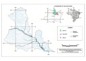
Figure 3. Flow chart of the methodological procedures.
(i) Area delimitation and identification of geoenvironmental units
The lower Rio Negro watershed was used as the unit of analysis due to its importance to environmental studies, which helped with the identification of landscape elements and their ongoing interrelationships and integration.
Based on the geodiversity map of the state of Amazon (CPRM 2009), the geoenvironmental domains and respective units that occur in the area were selected. These units were defined by geological constituents and relief patterns and characterized by the physical aspects of the environment, such as geology, geomorphology, pedology and hydrography, in the sense of Cendrero et al. (1992, 2004).
(ii) Selection of the ES classification
A review of the literature on ES with a focus on biodiversity and geodiversity was performed using the Scopus database and Web of Science. Various combinations of the following keywords were chosen for the search: ecosystem services, geodiversity valuation, environmental payments, ES, and Amazon. The term ‘geosystem services’ was used but did not return any answer.
Among the most widespread categorizations, the Millennium Ecosystem Assessment (MEA 2005) stands out and groups ES into four categories: provision, regulation, culture and support. Gray (2018), based on MEA (2005), approached ES with a focus on geodiversity and considered knowledge services as a subitem of the MEA cultural services group. The IPBES (2019) adopted the terminology “Nature's Contributions to People” (NCP), categorizing abiotic services into regulatory, material and nonmaterial services. The relationships between the three classifications are shown in Table 1. In this study, we used NCP/IPBS as a reference.
Table 1. Classification of ecosystem services according to the MEA (2005), Gray (2013) and IPBES (2019).
Ecosystem Services MEA (2005) | Geosystem Services Gray (2013) | Nature's Contributions to People (NCP) IPBES/UN (2019) |
Regulation | Regulation | Regulators |
Support | Support | Materials |
Provision | Provision | |
Cultural | Cultural | Nonmaterial |
Knowledge |
(iii) Identification and characterization of ES according to the geoenvironmental domains
This stage focused on identifying and categorizing ES derived from abiotic elements and geodiversity in the study area according to the geoenvironmental domains to address how the geological components influence or support these ES. This identification was performed based on field observations (Lima and Garcia 2023), conducted during visits to the region, supervised work by students, and participation in scientific events and meetings from 2018 to 2023 by the first author. Some ES were characterized through participatory dialogues, mainly for material (provision) and intangible (cultural) contributions, by using the local knowledge of riverine people shared in conversation circles, small workshops and interactive meetings, thus demonstrating the perceptions of the local actors involved.
In these events organized by the authors in the town of Novo Airão, the riverside dwellers and inhabitants of the city and its surroundings narrate, through audio and descriptive texts, their lived experiences and encounters. They share how they recognize the ecosystem services provided by geodiversity in their municipality. The responses are qualitatively described in the results section.
(iv) Evaluation of the ES and management proposals
A qualitative evaluation of ES according to Gray's (2013) definition was used to evaluate ES related to geodiversity. This evaluation was conducted through field observations, bibliographic studies and conversations with residents. During meetings, workshops, and conversations, 150 individuals, either individually or in groups, were interviewed. They shared their knowledge by responding to the following question: "In your opinion, what needs to be done to value and conserve the geo-environmental heritage of the region, and how could you contribute to this process?". From these responses, proposals regarding the management and conservation of the ecosystems, including the restoration of degraded areas and the creation of governance mechanisms to ensure their sustainable use, were elaborated.
Results
Geoenvironmental Domains and Units
The Geological Survey of Brazil states that the basis for understanding geodiversity is founded on the division of the territory into geosystems or geological-environmental domains, to evaluate geodiversity in the face of the multiple forms of human and economic appropriation of the territory (Silva and Dantas 2010). In this study, three domains were identified and subdivided into five geological-environmental units (Table 2), to gather lithological units with similar characteristics regarding the use and occupation of the basin and its relevant aspects related to the potentialities and limitations of each geological-environmental unit (Fig. 4).

Figure 4. Map of the domains and geoenvironmental units of the lower Rio Negro in the State of Amazonas, Brazil. Legend: Domain 1: unconsolidated or poorly consolidated Cenozoic sediments (alluvial plains unit-DCa and alluvial terraces unit- DCTa); Domain 2: Cenozoic covers lateritic detritus DCD (in situ lateritic horizon-DCDLi Unit); Domain 3: Domain of Mesozoic and Palaeozoic sedimentary and volcanosedimentary covers (sandstones and kaolinitic sandstones unit - DSVMPac and sandy, silty clayey sediments and shales unit - DSVMPasaf).
Table 2. Geosystems or geological-environmental domains and corresponding units that occur in the area studied.
Domain | Units | Geological features |
Domain 1. Domain of unconsolidated or poorly consolidated Cenozoic sediments in aqueous media | DCA Alluvial plains | Deposits of unconsolidated sediments of variable thickness and periodically flooded, which may constitute rectilinear deposits on the riverbanks or along meandering channels, forming islands, clogged lakes of varied conformations, sand bars or as abandoned deposits resulting from lateral migration of the channel. |
DCta Alluvial terraces | Wide and thick semi-consolidated fluvial sedimentary deposits consisting of sand, silt, clay, and alluvial deposits. | |
Domain 2: Domain of Cenozoic detritus - lateritic covers (DCD) | DCDLi Lateritic horizon | Ferruginous concretion covers formed in recent geological periods (<60 Ma) and related to the intense chemical weathering in rocks of different origins during the Paleogene and Neogene, with variations between humid and dry climates. |
Domain 3: Domain of the Mesozoic and Paleozoic sedimentary and volcanic-sedimentary covers (DSVMP) | DSVMPac Alter do Chão Formation
| Thick packages of slightly to moderately fractured sedimentary rocks, composed of massive quartz sandstones and white to reddish kaolinitic sandstones, stratified, with a subordinate conglomeratic fraction called the Alter do Chão Formation. |
DSVMPasaf Trombetas Group, Nhamundá Formation | Wide variety of sandstones from fine to coarse-grained, stratified to massifs, siltstones and laminated shales, comprising the Trombetas Group, part of the Nhamundá Formation. |
NCP Classification (Nature's Contributions to People)
The classification of NCP is strongly rooted in the classification of ecosystem services used by the MEA, and these changes reflect a conceptual evolution based on Díaz et al. (2018). The proposal is considered by some authors (IPBES 2019) as a maturing of the concept of ES and progress in transdisciplinary thinking, including a growing contribution of the social sciences and indigenous and traditional knowledge systems. In this work, this classification is used as a guide to describe goods and services provided by geodiversity to the local communities across the low Rio Negro according to the geoenvironmental domains. These findings are synthesized in Table 3.
In the study area, geological features contribute to the regulation of water flow and water quality in rivers and streams, which provides important benefits for ecosystems and human communities such as drinking water, flood control and irrigation, and soil regulation and erosion.
Table 3. The five geoenvironmental units used in the IPBES continuous assessments of specific NCP with some changes in abiotic variables from CICES 5.0: Geoenvironmental Units: (1) alluvial plains (DCa); (2) alluvial terraces (DCta); (3) in situ lateritic horizon (DCDLi); (4) Predominance of sandstones and kaolinitic sandstones (DSVMPac); (5) Intercalations of sandy, silty-clayey sediments and shales (DSVMPasaf).
Nature's Contributions to People | GEOENVIRONMENTAL UNITS | |||||
Goods and Processes | DCa | DCta | DCDLi | DSVMPac | DSVMPasaf | |
Regulatory Contributions | ||||||
Climate regulation | X | X |
| X | X | |
Regulation of soil erosion | X | X |
| X |
| |
Regulation of hazards and extreme events | X | X |
|
|
| |
Material Contributions | ||||||
Mineral substances used as materials, nutrients or energy | X | X | X | X |
| |
Habitat creation and maintenance | X | X |
|
|
| |
Formation, protection and decontamination of soils and sediments | X | X | X | X | X | |
Surface water used for nutrition, materials or energy | X | X |
|
|
| |
Groundwater used for nutrition, materials or energy | X | X | X |
|
| |
Non-material (intangible) Contributions | ||||||
Learning and inspiration | X | X | X | X | X | |
Physical and psychological experiences | X | X | X | X | X | |
Identity and support | X | X | X | X | X | |
|
|
|
|
|
|
|
The DCa and DCta units play a key role in climate regulation, ensuring the maintenance of the region’s thermal and water balance and influencing local and global weather patterns. These are characterized by soils rich in nutrients and subject to seasonal flooding. During the rainy season, these areas are inundated and operate as “sponges”, storing large bodies of water. This water is gradually released during the dry season and serves to regulate river levels and maintain water flow throughout the year (Figs. 5A, B).
During extreme floods, the areas in the DCa and DCta operate as natural reservoirs, absorbing and storing much of the excess water that flows from the rivers. This helps reduce the speed and impact of floods, protecting inhabited areas and infrastructure. During periods of drought, the alluvial areas gradually release the water stored during previous floods. This slow and steady release helps maintain the flow of water in rivers even during droughts, ensuring the sustainability of aquatic ecosystems and the availability of water for communities and human activities.

Figure 5. Geology and geomorphology of the Amazon Basin. A) Aerial view of the Anavilhanas Archipelago and the Amazon Forest, supported by local geodiversity, provides a global environmental service of climate regulation that is fundamental for the stability of the planet. B) Outcrop showing the sediments of the DCa unit consisting of rectilinear deposits on the banks of the Rio Negro and streams forming islands, beaches, and sand bars. C) Erosive processes developed in the DSVMPAc unit - Alter do Chão Formation. D) Fallen lands phenomenon in Amazonas (Brazil)
Due to the friable nature and limited presence of organic matter in lateritic soils of the DCDLi unit, they are easily eroded by the action of rain and wind. The lack of cohesion and the loose structure make these soils more easily erodible, leading to rapid water infiltration and surface runoff and increasing the risk of flooding during heavy rains.
Practices in the region, such as deforestation, agriculture without proper management and disorderly construction, can aggravate its vulnerability to exploitation in lateritic areas. To mitigate such actions, soil conservation measures should be implemented.
In DSVMP (Domain 3) Erosive processes, such as ravines and gullies, are quite common in roadblocks, often causing damage to road infrastructure and the construction of residential units (Fig. 5C).
These Quaternary deposits are associated with geological risk situations due to the possibility of flooding, erosive processes and mass movements with undermining of the riverbanks, an Amazonian phenomenon known as “fallen lands” (Fig. 5D).
Material Contributions
The ferruginous concretions of the DCDLi unit (Fig. 6A) present in the lateritic crusts are widely used in civil construction as a coating on local roads and branches and in the manufacture of bricks, in the preparation of mortar and the production of cement when they expose thick clayey horizons. Oxisols with distinct characteristics, such as high acidity, low natural fertility and high water retention capacity, stand out above the entire lateritic package. Even with low hydrogeological potential, this aquifer is used as an alternative for water extraction in places with difficult supply.
The lands of the DCLi are important due to their use and occupation (Fig. 6B), where the main arable areas of the state are located and, because they contain a series of rocky materials widely used in civil construction, act as a protective factor against the installation of erosive processes in certain types of crusts. Lateritic rocks support the relief-forming plateaus that stand out in the landscape.
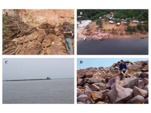
Figure 6. Sedimentary exposures along the Amazon. A) The lateritic horizons (DCDLi unit) formed by fine sandy sediments of a lateritic nature and ferruginous crusts used as the base and subbase of highways and roads in the region. B) DSVMPac unit comprising packages of fractured sedimentary rocks in the Tiririca rural community whose way of life is directly linked to the fluvial dynamics of the Negro River (Novo Airão/AM). C) Transport of sand by ferries, transporting the mineral raw material from the middle to the lower Rio Negro to Manaus, providing evidence that the Rio Negro is essential for the connectivity and economy of the region. D)Outcrop of the "Manaus Sandstone" lithofacies in the DSVMPac unit, corresponding to rocks that, due to their cohesion and resistance, are used as crushed stone and facing material.
The geological-environmental units DCa and DCta have mineral potential, mainly in the exploitation of sedimentary deposits of sand and clay for use as inputs in civil construction (Fig. 6C) and the red ceramic industry for tiles and bricks manufacturing.
The DSVMPac unit representing one of the areas of relevant mineral interest in the state are kaolin deposits, which are not yet commercially exploited and have small plastic clayey horizons resulting from lateritization processes that are widely used in brick production. Another outstanding geological resource is the "Manaus Sandstone" (Fig. 6D), a lithofacies in the unit that, due to its cohesion and resistance, has been used as crushed stone and coating material in various works and projects, including the buildings and monuments of the Center History of Manaus, such as the Amazonas Theater.
Surface and underground water resources are abundant in the basin and are used as sources of water supply, although because they are at a lower topographic level with a lower water table, they pose a risk of contaminating unconfined aquifers with high porosity. The hydrological and geological characteristics of the Amazon generate an intense dependence between surface and groundwater. The main factors that cause this connection are the high rainfall, the small topographic gradients, the extensive presence of surface sedimentary geological formations favorable to the transmission and storage of water, and the high territorial proportion of wetlands. (Wahnfried and Soares 2012)
Although the DSVMPac unit has high hydrogeological favorability, forming the main aquifer of the region (Alter do Chão), which is deep with great sandy expression and good water quality. This aquifer supplies a large part of the region's water demand, including part of the industrial hub in Manaus, the state capital.
Non-material (Intangible) Contributions
The river environments characteristic of the DCa and DCta units are marked by scenic beauty such as archipelagos, lakes and beaches, especially during the ebb of the Rio Negro, enhancing these environments for exploration of geotourism and artistic and contemplative inspiration of the landscape (Fig. 7A). Due to its abiotic characteristics, the domain is used as a habitat for several animals and birds and as a transitional habitat between aquatic and terrestrial ecosystems, such as birds and turtles, showing the interrelationship between geodiversity and biodiversity.
The cosmological narratives recounted by riverside dwellers demonstrate a direct connection with the diversity of materials and geological/geomorphological processes responsible for shaping the landscapes along the Negro River basin, such as rapids, waterfalls, rock formations, soils, hills, and mountains (Fig. 7B). They are representative of narratives like that of the Traíra Snake, as well as constellations (yõkoãpa ma’a) in the indigenous calendar described by Diakuru and Kisibi (1996), which play a crucial role in nature protection strategies.
The DSVPasaf unit includes important geotourism and educational attractions such as geoforms (Fig. 7C), rapids and waterfalls, and the establishment of mining heritage sites.
On the banks of some rivers and lakes, archaeological sites with ceramic objects and Amazonian dark earth (anthropic horizons) are observed, showing a cultural value associated with the geotouristic chain (Fig. 7D).
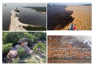
Figure 7. Interactions of geology and peoples along the Amazon. A) River deposition, where the population takes advantage of the environment for leisure and entertainment on the banks of the river, especially during the ebb of the Rio Negro, which enhances this unit for geotourism. B) Worldviews of the Meeting of the Waters of the Rivers Negro and Solimões. C) Paleozoic rocky outcrop of the Nhamundá Formation, Trombetas Group (DSVPasaf Unit), consisting mainly of fine white quartz sandstones, with little silt, with the Pedra Sanduíche geoform, which is of interest to tourists and has educational value. D) On the banks of the Negro River, archaeological sites show rock inscriptions in petroglyphs in the sandstones of the DSVPasaf unit.
These narratives point to two major categories of sacred places (Fernandes-Pinto and Irving 2015) in the view of indigenous peoples. Firstly, the ancestral "houses of transformation," associated with the journey of the canoe-snake, represent locations of great importance and power. Additionally, there are places linked to the origin of the world and the beings that came to inhabit it in primordial times, such as the fish people (waimahsã) who gave rise to both the plant species of the earth/forest (nuhkuri), the water (ahko), and the air (ome).
Proposals for management and conservation of ecosystems
As an integral aspect of the public consultation, the surveyed population put forth a range of collective initiatives that encompass the engagement of diverse communities, spanning from riverside inhabitants to local residents and visitors. Acknowledging the crucial necessity for increased participation from leaders and the community, they actively pursued the acquisition of fundamental knowledge in geosciences. Their primary emphasis lies in recognizing and valuing the identity that defines their citizens, shedding light on residents and their accomplishments by acknowledging traditional knowledge.
The participants underscored the significance of community involvement, collaborating with leaders representing each indigenous ethnicity. They endeavor to celebrate the cultural aspects embedded in ancestral civilizations. Their recommendations encompass conservation strategies, advocating for the training of local community members as monitors and guardians of the environment. Furthermore, they emphasize the necessity of fostering environmental respect and preservation by exploring sustainable methods for using natural resources.
Moreover, they champion the encouragement of dialogue within the community to facilitate the exchange of information concerning local knowledge. They promote the involvement of children in this undertaking to heighten awareness among residents regarding the importance of conservation values. Additionally, they put forth suggestions for enhancing the value of tourism initiatives that prioritize the needs of the locale and its inhabitants. This involves positioning guides, tourism operators, and traditional populations as key players in the execution of geotourism, with a focus on social and environmental sustainability, aspiring for them to evolve into custodians of natural heritage.
Discussion
The Legal Amazon region covers almost 60% of the Brazilian territory; it has the world’s largest and most diverse forest and largest reservoir of freshwater, which are extremely important for global climate regulation (Nobre et al. 2023). The area is inhabited by approximately 28 million Brazilians, in addition to 198 indigenous ethnicities belonging to almost 50 language families.
The Amazon biome has incomparable cultural and geobiological wealth and thus has been recognized as an "ecological paradise" (Hanan and Batalha, 1995); however, it has been facing chronic degradation challenges as a result of its efforts to attain economic growth, which is below Brazil's average. According to Nobre et al. (2023), this degradation directly threatens its ability to absorb carbon and provide essential ecosystem services, such as climate regulation and rainwater irrigation. These services are essential to preserve biodiversity, conserve geodiversity and ensure the quality of life of traditional communities that depend on the forest.
The Amazon Forest, supported by local geodiversity, provides a global environmental service of climate regulation that is fundamental for the stability of the planet (Capobianco et al. 2001). The high precipitation rates, combined with the fact that it represents one of the most preserved regions of the Amazon, make the Rio Negro of enormous relevance in the maintenance of ecosystem services on a regional and global scale.
The Rio Negro is a direct or indirect source of water supply to riverside municipalities upstream of Manaus, supplying approximately 44 thousand inhabitants (ANA 2017). Regarding groundwater demand, the Alter do Chão aquifer/aquitard is of the free type (ANA 2015) and is also of fundamental importance for the supply of the cities of Manaus and other municipalities on the banks of the Rio Negro. Another service provided is the use of the main bed of the Rio Negro as a waterway, which plays a crucial role in the infrastructure and development of the region. The watercourse is the main means of non-air transport within the region; it is also used to transport passengers between the cities that make up the river channel and is a tourist destination, especially for those who practice sport fishing and ecotourism (Silva et al. 2023).
The lower Rio Negro Mosaic is also home to a diversity of protected areas, such as the Jaú and Anavilhanas National Parks, the Tupé Sustainable Development Reserves, the Rio Negro State Park, two Ramsar sites (UN) and the Biosphere of Central Amazonia (UNESCO). In addition to the protected areas, traditional communities such as indigenous, riverine and quilombola communities coexist, and their existence is based on sustainable systems of exploitation of natural resources. In general, these traditional populations use the banks of the Negro River for tourism and leisure or exploit forest resources for extractive activities, small gardens, hunting and subsistence fishing (Mariosa et al. 2020).
Relationships between Geoenvironmental Units and NPC
Based on the findings outlined in the study, the identified geological-environmental units play crucial regulatory roles in both ecosystems and local human communities. Notably, geological characteristics serve to regulate the flow and quality of water within the Negro River and its tributaries, contributing significantly to the provision of drinking water for populations without access to a public supply system. Furthermore, these characteristics contribute to flood control in key urban centers along the river's course, including Barcelos, Novo Airão, and particularly Manaus. Another regulatory function involves the irrigation of small-scale agricultural areas and the control of soil erosion, particularly within the geoenvironmental units DSVMPac and DSVMPasafem.
The geoenvironmental units also make noteworthy material contributions to local communities, particularly in terms of extractable resources. For instance, the DCa's deposits of gravel, sand, and clay are vital sources of mineral resources essential for civil construction. The DCDLi and lateritic crusts contain materials used in the manufacturing of bricks, mortar, and cement, along with ferruginous concretions that find applications in construction as pigmentation materials and in brick production. Moreover, the aquifers primarily formed within the DCDLi and DSVMPac units serve as crucial sources of water for human consumption, underscoring the importance of the Alter do Chão aquifer in supporting human activities and local development.
The presence of diverse geological formations, exemplified by the Nhamundá Formation, becomes apparent through erosive processes in the DSVPasaf unit, forming distinctive geoforms, and the picturesque beach landscapes in the DCa unit. This geological richness offers substantial prospects for the advancement of geotourism, fostering revenue generation for local communities and promoting environmental awareness with a focus on geoconservation. Furthermore, the region's geological diversity serves as a crucial intangible service for scientific research, aiding in a more profound comprehension of Earth's mechanisms and its geological evolution across time.
This discourse underscores the interconnectedness of geological, environmental, social, and economic facets. The geological-environmental units assume diverse roles, spanning from water resource regulation to the provision of indispensable construction materials and contributions to the local economy. Consequently, there is a recognition of the significance of identifying and preserving the geodiversity elements within the mapped units for the environmental and socioeconomic sustainability of the region. The responsible stewardship of geological resources and the conservation of geodiversity emerge as pivotal in maintaining a delicate equilibrium between human development and the preservation of natural ecosystems. These endeavors are fundamental to ensuring the sustainability of human activities within the region.
Based on the IPBES, Anderson et al. (2019) developed strategies to guide decisions on NCP to achieve sustainable development goals (SDGs). Specifically, the researchers prioritized contributions, recognizing the plural values of nature, and grouped several human-nature relationships to focus attention on important NCP-SDG links.
Community Proposals for the Management and Conservation of Natural Resources
Engaging in consultative activities with local communities proved effective in analyzing and formulating practical, reality-based proposals. When queried about the significance of ecosystem services offered by geodiversity in the area, riverside residents predominantly underscore the abundance of potable water in aquifers, lakes, and reservoirs. Additionally, they emphasize the necessity for improved flood control during the high-water season of the Negro River, characterizing these measures as vital regulatory services.
Another aspect that was strongly emphasized was cultural meanings related to geodiversity, which were intertwined with artistic inspirations, spiritual experiences, moments of leisure, and family entertainment. According to their expressions, "there is no flora and fauna without knowledge of the geological history of the region, as the concepts become empty." It is noteworthy to highlight the allusions to folklore and regional dances within cultural performances by groups like Peixe-boi Anavilhanas and Peixe-boi do Jaú. The names of these groups are directly linked to two National Parks in the region: Anavilhanas National Park and Jaú National Park, underscoring the significance of their presentations in the conservation of geodiversity and the safeguarding of local biodiversity.
Based on the scientific knowledge of specialists and the local traditional population, the following recommendations to ensure the rational and sustainable use of geodiversity ecosystem resources in various areas and approaches can be approached:
● Economic Potential: Communities can exploit the mineral resources present, such as sand, clay and kaolin, for civil construction and the ceramics industry, generating local income through controlled and sustainable mining activities. Only mining companies are established in locations with environmental control and outside PAs.
● Geotourism: Scenic beauty and images, such as rapids, caves and beaches, can be explored for the development of tourist activities, increasing employment and income opportunities.
● Soil conservation: An understanding of the fragility of lateritic soils can increase community awareness regarding the importance of sustainable practices for subsistence agriculture and land management in avoiding erosion and degradation.
● Water resources: Taking advantage of the aquifer formed by the hydrogeological unit may be an alternative to ensure water supply in areas with difficult access and already compromised quality.
● Risk Management: An understanding of erosive processes and the need for proper management can help communities take measures to protect their infrastructure and prevent natural disasters.
Conclusions
The detailed analysis of the geological-environmental units identified in the study and their relationship with the CNP elucidates the importance of geodiversity in the studied region. An understanding of the regulatory, material and non-material contributions of geological features is fundamental for an integrated and sustainable approach to land and natural resource use, aimed at the benefit of both local communities and the environment in which they live.
In addition, all geoenvironmental units provide insights into the interaction between geodiversity and biodiversity, indicating the importance of environmental conservation and sustainable management of natural resources. This information can encourage land use practices that respect local ecosystems and promote harmonious coexistence between communities and the surrounding environment. Besides their economic value, these units play vital roles in climate regulation, flood control, ecosystem preservation and water availability for rural communities.
Geodiversity elements play a crucial role in supporting and providing essential natural resources for local communities. The conservation of these services is vital not only for environmental sustainability, which protects geological heritage but also for ensuring the identity and improvement of the quality of life of riparians. Also, scientific knowledge, when applied in a conscious and participatory manner, has the potential to inform and promote policies, management practices and economic activities that benefit both riverside communities and their environments, thus promoting sustainable development and harmony between humans and nature.
In the Amazon, diagnosis of nature's contributions also has the potential to guide actions and decisions to achieve UN sustainable development goals (SDGs). As proposed by Anderson et al. (2019), the environment should be integrated across several development sectors, using strategies related to the prioritization of these contributions, the recognition of the diverse values of nature, and the categorization of human-nature relationships to focus attention on the connections between NCP and SDGs. In the area studied, this approach may broaden the range of criteria considered for environment-development evaluations and create bundles that simplify the incorporation of complexity into decision-making processes according to the needs of riverine populations.
Acknowledgments
The authors express their gratitude to the Institute of Geosciences of the University of São Paulo for supporting the research of the first author in its postdoctoral stage. Special thanks to the Foundation for Research Support of the State of Amazonas/FAPEAM (Notice 007/2021 Biodiversa) for funding the fieldwork. M.G.M Garcia thanks the CNPq [Grant 314689/2021-4]. The authors also thank the contributions of the population who participated in the events promoting geoconservation in the region, particularly the communities of Tumbira, Novo Airão, Tiririca, Iranduba, Presidente Figueiredo, and Manaus.
Conflict of Interest:
The authors declare no competing interests.
References
Alahuhta J, Ala-Hulkko T, Tukiainen H, Purola L, Akujärvi A, Lampinen R, Hjort J (2018). The role of geodiversity in providing ecosystem services at broad scales. Ecological Indicators. 91: 47–56.
Alves NDS (2013). Mapeamento hidromorfodinâmico do Complexo Fluvial de Anavilhanas: contribuição aos estudos de Geomorfologia Fluvial de rios Amazônicos.Tese (Doutorado). Programa de Pós-graduação em Geografia Física. São Paulo.
ANA Agência Nacional de Águas (2015). Avaliação dos Aquíferos das Bacias Sedimentares da Província Hidrogeológica Amazonas no Brasil (escala 1:1.000.000) e Cidades Pilotos (escala 1:50.000). Volume III – Hidrogeologia e Modelo Numérico de Fluxo da PHA no Brasil. Brasília: ANA, SIP, 2015.
ANA Agência Nacional de Águas (Brasil) (2017) Conjuntura dos recursos hídricos no Brasil: relatório pleno / Agência Nacional de Águas. Brasília: ANA, 2017. 169p.: iI.
Anderson CB, Seixas CS, Barbosa O (2019). Determining nature’s contributions to achieve the sustainable development goals. Sustainability Science. 14: 543–547. https://doi.org/10.1007/s11625-018-0643-5
Barbosa RCM, Nogueira ACR (2011). Paleoambiente da Formação Prosperança, embasamento neoproterozoico da Bacia do Amazonas. Revista Brasileira de Geociências. 41: 01-17. https://doi.org/10.25249/0375-7536.20114110117.
Barbosa RO (2015). Estudos sedimentológicos e estratigráficos dos depósitos sedimentares quaternários do arquipélago de Anavilhanas, município de Novo Airão (Amazônia Central). Dissertação (Mestrado). Programa de Pósgraduação em Geociências. Universidade Federal do Amazonas, Manaus.
BRASIL, ICMBio (2017). Plano de Manejo do Parque Nacional de Anavilhanas – versão resumida. Novo Airão.
Brilha J (2004). A Geologia, os Geólogos e o Manto da Invisibilidade. Comunicação e Sociedade. 6: 257–265.
Brilha J (2005). Patrimônio Geológico e Geoconservação: A conservação da natureza na sua vertente geológica [Geological heritage and geoconservation: Nature conservation in its geological aspect], Palimage, Braga.
Capobianco JPR, Veríssimo A, Moreira A, Sawer D, Ikeda S, Pinto L (2001). Biodiversidade na Amazônia Brasileira: avaliação e identificação de ações prioritárias para a conservação, utilização sustentável e repartição dos benefícios da biodiversidade na Amazônia brasileira”, Programa Nacional de Diversidade Biológica (Pronabio/MMA), 540p.
Carcavilla-Urqui JJ, Durán J, López-Martínez (2008). Geodiversidad: Concepto y relación con el patrimonio geológico [Geodiversity: Concept and relationship with geological heritage] GeoTemas. 10: 1299–1303.
Cendrero A, Francés E, Diaz del Teran JR (1992). Geoenvironmental units as a basis for the assessment, regulation and management of the Earth’s surface. In: Cendrero A, Luttig G, Wolff FC (eds) Planning the use of the Earth’s surface. Springer Verlag, New York.
Cendrero A, Frances A, Del Corral D (2004). Environmental quality indices: a tool for assessing and monitoring geoenvironmental map units.
Costanza R, d’Arge R, de Groot R, Farber S, Grasso M, Hannon B, Limburg K, Naeem S, O’Neill RV, Paruelo J, Raskin RG, Sutton P, Belt MVD (1997). The value of the world’s ecosystem services and natural capital. Nature. 387: 253–260.
CPRM Serviço Geológico do Brasil (2006). Geologia e recursos minerais do Estado do Amazonas: Sistema de Informações Geográficas (SIG). Escala 1: 1:000.000. Rio de Janeiro: CPRM, 2006. CD--ROM. Programa Geologia do Brasil: integração, atualização e difusão de dados da geologia do Brasil. Mapas geológicos estaduais.
CPRM Serviço Geológico do Brasil (2009). Mapa de Geodiversidade do estado do Amazonas. http://www.terrabrasilis.org.br/ecotecadigital/pdf/mapa-de-geodiversidade-do-estado-do-amazonas.pdf
Cunha DF (2017). Evolução Sedimentar do Arquipélago de Anavilhanas no baixo Rio Negro, Amazônia central [Sedimentary evolution of Anavilhanas archipelago in lower Rio Negro, Central Amazon] (Master’s thesis), Institute of Geosciences, University of São Paulo, Brazil.
de Groot RS, Alkemade R, Braat L, Hein L, Willemen L. (2010). Challenges in integrating the concept of ecosystem services and values in landscape planning, management and decision making. Ecological Complexity. 7: 260–272.
Diakuru ACF, Kisibi DMF (1996). A mitologia sagrada dos antigos Desana do grupo Wari Dihputiro Põrã. V. 2, Coleção Narradores indígenas do Rio Negro. Editora UNIRT, São Gabriel da Cachoeira: FOIRN/ISA.
Díaz S, Pascual U, Stenseke M, Martín-López B, Watson RT, Molnár Z., ... & Shirayama Y (2018). Assessing nature's contributions to people. Science 359: 270–272. Doi: 10.1126/science. aap882
EMBRAPA, Empresa Brasileira de Pesquisa Agropecuária. (2017). Sistema Brasileiro de Classificação de Solos. 5th ed. Fonte/Imprensa: Brasília, DF.
Fernandes-Pinto E, Irving MA (2015). Sítios Naturais Sagrados no Brasil: o gigante desconhecido. In Hanazaki N., et al. (Orgs.). Culturas e Biodiversidade: o presente que temos e o futuro que queremos. Anais do VII Seminário Brasileiro sobre Áreas Protegidas e Inclusão Social e II Encontro Latino Americano sobre Áreas Protegidas e Inclusão Social, Florianópolis: Universidade Federal de Santa Catarina, disponível em http://sapiselapis2015.paginas.ufsc.br/anais
Filizola N, Guyot JL, Molinier M, Guimarães V, de Oliveira, E, de Freitas MA (2002). Caracterização hidrológica da Bacia Amazônica', em Rivas, A. e Freitas, CE, Amazônia uma perspectiva interdisciplinar, 2002, EDUA, Manaus.
FIRJAN (2020). Índice FIRJAN de Desenvolvimento Municipal (IFDM), Confins [Online],44/2020,online, 15 março 2020, http://journals.openedition.org/confins/26246.
Fox N, Graham LJ, Eigenbrod F, Bullock JM, Parks KE. (2020). Incorporating geodiversity in ecosystem servisseservice decisions. Ecosystems and People. 16: 151–159.
Gordon JE, Barron HF, Hansom JD, Thomas MF. (2012). Engaging with geodiversity – why it matters. Proceedings of the Geologists’ Association. 123: 1– 6.
Gordon JE and Barron HF (2013). The role of geodiversity in delivering ecosystem services and benefits in Scotland. Scottish Journal of Geology 2013. 49 (1): 41–58. doi: https://doi.org/10.1144/sjg2011-465
Gray M (2004). Geodiversity: valuing and conserving abiotic nature. 1st edition. Chichester, John Wiley &Sons, 434 p
Gray M (2012). Valuing geodiversity in an ‘ecosystem services’ context. Scottish Geographical Journal. 128: 177–194. https://doi. org/ 10. 1080/ 14702 541. 2012. 725858
Gray M (2018). Geodiversity: the backbone of geoheritage and geoconservation. In: Reynard, E and Brilha, J (eds) Geoheritage: assessment, protection and management. Elsevier, Amsterdam, p.13–25
Gray M (2013). Geodiversity: Valuing and conserving abiotic nature, John Wiley & sons, Londres.
Gray M, Gordon JE, Brown EJ (2013) Geodiversity and the ecosystem approach: the contribution of geoscience in delivering integrated environmental management. Proceedings of the Geologists’ Association. 124: 659–673. https://doi.org/10.1016/j.pgeola.2013.01.003
Hanan SA, Batalha BHL (1995). Amazônia: contradições no paraíso ecológico. Bartira Gráfica e Editora. Cultura, Rio de Janeiro. 265p.
Instituto Trata Brasil (2022). Benefícios econômicos e sociais da expansão do saneamento no Brasil. São Paulo. https://tratabrasil.org.br/beneficios-economicos-e-sociais-da-expansao-do-saneamento-no-brasil/
IPBES (2019). Report of the plenary of the intergovernmental science-policy platform on biodiversity and ecosystem services on the work of its seventh session https://ipbes.net/sites/ default/files/ipbes.
Kozłowski S (2004). Geodiversity. The concept and scope of geodiversity. Przegląd Geologiczny. 52: 833–837.
Lima RHC, Garcia MGM (2023). Serviços ecossistêmicos da geodiversidade: abordagem preliminar no Parque Nacional de Anavilhanas e seu entorno, Amazônia, Brasil. América Latina ante los (nuevos) retos de la justicia social y ambiental. Editora Associação Espanhola de Geografia Gusman, Guilarte, Cidras, Vila varques y Gonzales (coord). Madrid: Asociación Espanola de Geografia. p. 27-288. https://doi.org/10.21138/al/2023.17
Lira TDM; Chaves MDPSR (2016). Comunidades ribeirinhas na Amazônia: organização sociocultural e política. Interações (Campo Grande). 17:66-76. https://doi.org/10.20435/1518-70122016107
Marinho RR (2021). Perfil longitudinal do rio Negro a partir da altimetria radar. In: Marcos Castro de Lima; Nelcioney José de Souza Araújo; Manuel de Jesus Masuloda Cruz. (Org.). A Geografia Amazônica em múltiplas escalas. 1ed. Manaus: EDUA,2021.
Mariosa D, Santos-Silva EM, Gasparini L, Reis Junior AM (2020). Ribeirinhos do rio Negro: Um estudo da qualidade socioambiental. CRVISBN: 978-85-8042-7.
MEA, MILLENNIUM ECOSYSTEM ASSESSMENT. (2005). Ecosystems and human well-being: synthesis. Island Press: Washington, DC.
Nobre CA, Feltran-Barbieri R, Costa FA, Haddad EA, Schaeffer R, Domingues P, Frasson CMR, Camuri PA, Genin, Szklo A, Lucena AFP, Ferandes DA (2023). Nova Economia da Amazônia. São Paulo: World Resources Institute, WRI Brasil. Relatório. Disponível online em: www.wribrasil.org.br/nova-economia-da-amazonia https://doi.org /10.46830 /wrirpt.22.00034
Panizza M, Piacente S (2008.) Geomorphosites and geotourism. Revista Geográfica Acadêmica. 2(1): 5–9.
Pereira RGF A. (2010). Geoconservação e Desenvolvimento Sustentável na Chapada Diamantina (Bahia-Brasil). Tese (Doutorado). Portugal: Universidade do Minho.
Prosser CD, Brown EJ, Larwood JG, Bridgland DR (2013) Geoconservation for science and society – an agenda for the future, Proceedings of the Geologists' Association. 124: 561-567, https://doi.org/10.1016/j.pgeola.2013.04.003.
Queiroz DS, Garcia MGM (2022). The “hidden” geodiversity in the traditional approaches in ecosystem services: A perspective based on monetary valuation Geoheritage. 14: 44. 10.1007/s12371-022-00676-x
RADAMBRASIL. (1978). BRASIL. Departamento Nacional de Produção Mineral. Projeto RADAMBRASIL: folha EM 20 Manaus – geologia, geomorfologia, solos, vegetação e uso potencial da terra. Rio de Janeiro: DNPM, 1978. 628 p. + mapas.
Reis ACF (1997). O seringal e o seringueiro. Manaus: Editora da Universidade do Amazonas.
Silva CL (2005). Análise da tectônica cenozóica da região de Manaus e adjacências. Tese (Doutorado Programa de Pos Graduação em Geociências), Universidade Estadual Paulista, Rio Claro, SP, Brasil.
Silva SRA, Souza AGH, Lima RHC, Garcia MGM (2023). Uso turístico e educativo de sítios geológicos: estudo preliminar no baixo Rio Negro, Amazonas, Brasil. Geologia USP. Série Científica. 23: 139–152.
Silva CR, Dantas ME (2010). Mapas Geoambientais. http://rigeo.cprm.gov.br/ bitstream/ doc/17873/1/ mapas geoambientais_sbcgg.pdf.
Soares EAA, Tatumi SH, Riccmini C (2010). OSL Age Determinations of Pleitocene fluvial deposits in Central Amazonia. Anais da Academia Brasileira de Ciências. 82: 691699.
Van der Meulen ES, Braat LC, Brils JM (2016) Abiotic flows should be inherent part of ecosystem services classification. Ecosystem Services. 19: 1–5. https:// doi. org/ 10. 1016/j. ecoser. 2016. 03. 007
Van Ree CCF & Van Beukering PJH. (2016). Geosystemservices: a concept in support of sustainable development of the subsurface. Ecosystem Services. 20: 30–36
Wahnfried I, Soares EAA (2012). água subterrânea na Amazônia: Importância, estado atual do conhecimento e estratégias de pesquisa. Ciência & Ambiente. 44: 29-40.