Introduction
The Azores UNESCO Global Geopark is located in the North Atlantic Ocean, in a special geotectonic setting, corresponding to the triple junction of the lithospheric plates of Eurasia, Africa and North America (Laughton & Whitmarsh 1974), roughly crossed N–S by the Mid-Atlantic Ridge and by the GLORIA Fault, that integrates the Azores-Gibraltar Fault, with a general E–W trend. Its territory is limited by the 2,000 m depth bathymetric line, from where the volcanoes that build up the islands rise (Nunes et al. 2011) (Fig. 1).
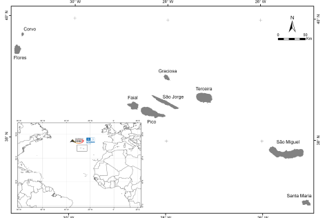
Figure 1. Geographic setting of the Azores archipelago.
The archipelago is a Portuguese Autonomous Region and comprises nine inhabited islands and several non-inhabited islets geographically distributed in the Western Group (Flores and Corvo islands), the Central Group (Faial, Pico, São Jorge, Graciosa and Terceira islands) and the Eastern Group (São Miguel and Santa Maria islands). It is characterized by the small dimension of the islands (between 17 and 745 sq. km), by its dispersion (along 600 km) and its distance from the European and American continents, 1815 km and 2625 km, respectively (Fig. 2).
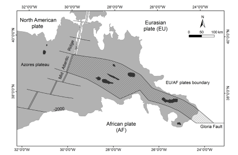
Figure 2. Geodynamic setting of the Azores archipelago (adapted from Nunes et al. 2011).
The Azores are oceanic islands of volcanic origin that started to form around 36 million years (My) ago, when different submarine volcanic phenomena caused a rising of the sea floor due to the stacking of volcanic material (Searle 1980). This submarine volcanism is deeply linked to the opening of the Atlantic Ocean. The oldest subaerial volcanism dates back to the Upper Miocene (~6 My) in Santa Maria Island (Ramalho et al. 2017), and the youngest island of the archipelago is Pico Island, formed about 270 ka ago (Chovelon 1982). Though the outermost islands from the Mid-Atlantic Ridge are generically older, there is no clear migration of the volcanic activity, whether on a regional scale or on an insular scale. There are records of about 26 historical eruptions, since the settlement of the islands in the 15th century, one of the most recent being the well-known Capelinhos eruption in 1957–1958, on Faial Island (Fig. 3).
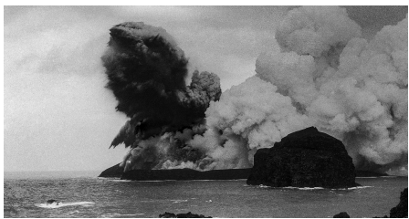
Figure 3. Capelinhos eruption in 1957/58 (Photograph by Tenente Coronel José Agostinho)
In the Azores islands there are currently identified 27 volcanic systems, 16 of them are polygenetic central volcanoes (most of them siliceous and with subsidence calderas) and 11 basaltic volcanic ridges. Among these, nine polygenetic volcanoes and seven areas of fissural volcanism are considered active, although dormant. Manifestations of secondary volcanism are identified at Banco D. João de Castro, a submarine polygenetic volcano that erupted in 1720 and is located between the islands of São Miguel and Terceira, and in the islands of São Miguel, Terceira, Graciosa, São Jorge, Pico and Faial. There are about 1750 monogenetic volcanoes in the archipelago (including domes and their coulées, tuff rings, tuff cones, maars, scoria and spatter cones), dispersed along the flanks and inside the calderas of central volcanoes or belonging to the 11 basaltic volcanic ridges (Nunes & Lima 2008).
The singularity of the geological heritage of the territory allowed the creation of the Azores UNESCO Global Geopark, one of the first archipelagic geoparks, this new geographical setting being a challenge for the geoparks network. A volcanic archipelago with its fearless people, in the middle of the Atlantic, was exotic enough to integrate into the mix of geoparks in Europe and even in the globe. So, in March 2013 the Azores Geopark was included in the European and Global Geopark Networks and it was recognized as a UNESCO Global Geopark, since November 2015. The Azores Geopark stood out for being settled in a network of geosites spread over the nine islands and the surrounding seafloor and for its decentralized management structure with support in all the islands (Nunes et al. 2011).
Geological Heritage and Geoconservation
The geodiversity of the Azores archipelago comprises elements related to the volcanism and tectonics of this region of the globe, formed through different types of eruptions, their dynamics and subsequent erosive processes (Nunes 2002). Volcanoes, calderas, lagoons, fumaroles, thermal springs, and volcanic caves, among others, are characteristic elements that turn these islands into an authentic laboratory of geodiversity (Nunes et al. 2011; Lima et al. 2014, 2018). The existence of such richness and the awareness of its value indicated the need for study.
The Azores UNESCO Global Geopark territory has an important geological heritage that has been the subject of several geoconservation studies (Lima 2007, 2018; Nunes et al. 2011; Brilha & Pereira 2012). The main criteria that guided the inventory and selection of geosites in the Azores included: i) knowledge and scientific value of the region; ii) representativeness at the scale of the archipelago; iii) its integrity; and iv) and whether they constitute a privileged or essential place for the observation of aspects and key elements in the regional geological and volcanological context, considering landscape and pedagogical values. To achieve a sustained and comprehensive approach, scientists and researchers had to collaborate in assessing the inventory (Nunes et al. 2011).
121 geosites were identified throughout the nine islands and the surrounding marine area, ensuring the representativeness of the geodiversity of the archipelago and reflecting its geological and eruptive history of 6– 8 My (Ramalho et al. 2017). Qualitative and quantitative analyzes were also applied, integrating geological characterization, geomorphological and volcanological categorization, relevance analysis, identification of type of use, and associated values, such as scientific, educational, and touristic (Lima 2007, 2018). Following these categories and specifying aspects of volcanic morphology according to Wood (2009), 23 categories were defined, including geosites that are coastal cliffs, polygenetic volcanoes with a caldera, volcanic caves, prismatic and spheroidal disjunctions, pieces of evidence of historical eruptions, dykes, river valleys, and hydrothermal areas (Lima & Nunes 2014).
Geosites were also analyzed for relevance, identifying six geosites of international relevance (Figs. 4–9), 52 geosites of national relevance and 63 geosites of regional relevance. The geosites of international relevance are: i) the Mid Atlantic Ridge, as it is a tectonic limit on a global scale; ii) the Furnas volcano caldera (São Miguel Island), which exhibits important hydrothermal and hydrological systems and is considered a laboratory volcano; iii) Pico Mountain (Pico Island), the third highest central volcano in the North Atlantic; iv) the Graciosa caldera volcano and Furna do Enxofre volcanic cave (Graciosa Island), due to the shape, size and genesis of the cave; v) the Capelinhos and Costado da Nau volcanoes (Faial Island), considered a type-volcano for understanding submarine eruptions in shallow waters and due to the relevance of the Capelinhos eruption to volcanology; vi) and Algar do Carvão (Terceira Island), as it is one of the world's top ten volcanic caves in terms of silica mineral deposits (speleothems) (Sigurdsson et al. 2000; Nunes et al. 2011; Lima et al. 2014; Lima 2018). It is worth mentioning that the Capelinhos volcano was selected for the list of the First 100 IUGS Geological Heritage Sites, presented in Zumaia (Basque Coast UGGp) in October 2022.
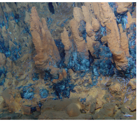
Figure 4. Mid-Atlantic Ridge and deep-sea hydrothermal fields (Photograph by ©Missão Seahma, 2002 (FCT/PDCTM 1999/MAR/15281).
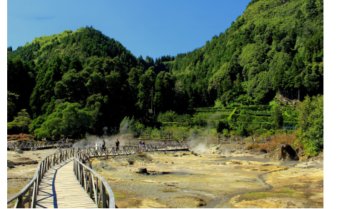
Figure 5. Furnas volcano caldera, São Miguel Island (Photograph by Paulo Garcia).
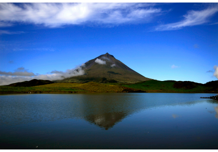
Figure 6. Pico Mountain, Pico Island (Photograph by Paulo Henrique Silva/SIARAM).
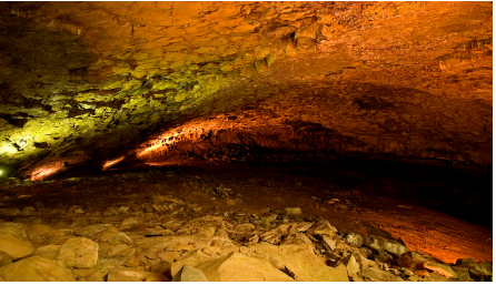
Figure 7. Graciosa caldera volcano and Furna do Enxofre volcanic cave, Graciosa Island (Photograph by Paulo Henrique Silva/SIARAM).
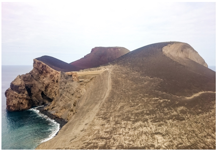
Figure 8. Capelinhos and Costado da Nau volcanoes, Faial Island (Photograph by Salomé Meneses)
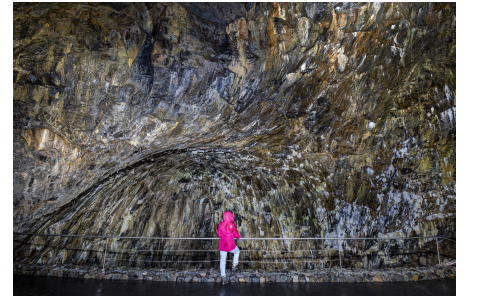
Figure 9. Algar do Carvão volcanic pit, Terceira Island (Photograph by Os Montanheiros).
Almost all geosites are used for scientific purposes, with geotouristic and educational activities also taking place in most of them. Approximately a third of the geosites have associated economic activities related to paid visitation or use of geosites, through the extractive industry, or the production of geothermal energy (Lima 2018). Geological sites are sometimes associated with other relevant heritage elements, such as landscape, cultural (showing the intrinsic relationship of the Azoreans with their volcanoes) and ecological (since several geosites create conditions and are the substrate for important ecosystems and habitats) (Lima 2018).
Although in 1972 the Integral Reserves of Caldeira do Faial and Pico Mountain (Legislative Decree n.º 78/72, of March 7, and Legislative Decree n.º 79 /72, of March 8) were created, they were not classified as there was no legal consideration of geological characteristics. Since then, several protected areas have been created on the islands and surrounding sea, with a revision taking place at the beginning of the 20th century. The Regional Legislative Decree no. 15/2007/A reclassifies the Azorean protected areas according to the International Union for Conservation of Nature (IUCN) categories. This new law integrates geological elements for the first time in the region and in the country (Lima et al. 2014). The review of protected areas was contemporary with the first geoconservation work in the region, with an exchange of knowledge that culminated in the integration of several geosites into the current Regional Network of Protected Areas (Lima 2018). Currently, 77% of the Azores UGGp geosites (93 geosites) are under legal protection of the Island Natural Parks, Azores Marine Park or Natura 2000 Network. Their respective legal documents (Regional Decrees n.º 19/2008/A, 44/2008/A, 45/2008/A, 46/2008/A, 47/2008/A, 8/2011/A, 10/2011/A, 11/2011/A, 12/2012/A, 28/2011/A, 39/2012/A, 11/2018/A, 10/2019/A) define prohibited or conditioned activities and an administrative offense regime.
Several parts of the territory are protected for their geological interest, including 23 Natural Reserves, 11 Natural Monuments, 7 Protected Areas for the management of habitats or species, seven Protected Areas for the management of resources, and eight Protected Landscape Areas; the class A volcanic caves are legally protected under the Regional Decree 10/2019/A, of May 22, and integrated into the Natural Park of the respective island; and the Paleopark of Santa Maria island, created by Regional Legislative Decree n.º 11/2018/A, of August 28, protects the fossil deposits of Santa Maria island, and aims to maintain paleobiodiversity and the integrity of geological and associated values.
Therefore, the quantity and quality of the Azorean geosites, their international relevance and high range of geodiversity, together with the rich biodiversity and a notable cultural heritage of the archipelago, sustain the Azores UNESCO Global Geopark through the motto of “Nine Islands - One Geopark”, a territory where the community is invited to “Enjoy an eruption of flavors, smells and experiences!” The geoconservation work is continuous: (i) a review of geosites has been taking place since 2020; (ii) the main and most effective geoconservation action, currently applied, is monitoring of the terrestrial geosites, in cooperation with Nature Rangers, ensuring the conditions of geological heritage, conservation and sustainable use; (iii) in 2022 a new geosite was identified, Ponta da Ajuda in São Miguel Island, being the largest outcrop of columnar jointing on this island.
Since August 2022, the Azores UNESCO Global Geopark has been included in the Regional Council for the Environment and Sustainable Development, where important decisions are made concerning our territory, including misuse and damage of natural resources. Being part of this council allows our geopark to be involved in the establishment of management measures to mitigate or prevent damage to geosites.
Geotouristic Potential
The unique geological and geographical setting of the archipelago allowed the development of outstanding landscapes and a genuine culture, deeply linked to volcanic eruptions and earthquakes. The volcanic landscape and the oceanic setting are, by far, the main attractions on the archipelago, fascinating travelers, scientists and distinguished naturalists (Lima 2007) since the settlement of the islands (15th century): Charles Darwin briefly visited the Azores in the summer of 1836; Ferdinand Fouqué traveled to the Azores on a scientific mission during the second half of the 19th century and, among many other travelers, Prince Albert of Monaco reached for the Azores during his oceanographic research. Still today, the Azores are considered a hotspot for scientists and travelers.
Since the explosion of tourism in the archipelago it has become apparent that visitors search for the scenic aspects of our volcanic/oceanic landscapes, mainly for their landscape beauty. This sector has been growing in our region during the last years, along with the consciousness of a need for sustainable development. The establishment of the Azores UNESCO Global Geopark brought a refreshed approach to the touristic offer on the territory, implementing a strategy for geotourism and highlighting the link between natural and cultural values. Important achievements have enriched the geotouristic offer, providing a wider range of possibilities to explore and experience the islands, scattering visitors and lowering the pressure on hotspot sites (Lima & Machado 2018).
The strategy of the Azores Geopark for geotourism targets the maximization and enhancement of existing services and touristic infrastructures and empowers partners, providing a platform of information and strategies for environmental awareness. During the last years, the network of walking trails was enriched with more trails and more information available for users; interpretive centers promote good practices and provide accurate and attractive information on natural areas allowing safe and responsible use of geosites, as in the case of vulnerable sites like Capelinhos volcano, Pico Mountain or volcanic caves.
The promotion of the geological heritage and geodiversity by the Geopark encouraged the touristic sector, both companies and public entities, to look at the landscapes and volcanic structures of the islands as a resource with the potential to generate income and sustainable leisure use, to increase the length of stay of visitors. Also, through training courses and workshops promoted by the geopark in the scope of geotourism, new products and new tourism companies were created on several islands. Touristic companies offer a wide range of experiences connected with geotourism including walking trails, geotours, speleological activities, and coasteering, as a way to discover the geodiversity and the geological heritage of the islands. Rural tourism accommodations have geological names or decorations, and some are located in geosites. Other partners of the geopark have developed gastronomic or handcraft geo-products with endogenous resources. The GEOfood project and brand, brought the missing link between food and territory, allowing the development of a more conscious and genuine product that is certified only in UNESCO Global Geoparks.
The Azores Geopark and its partners promote a sustainable and genuine way to experience the islands. Worth mentioning are the implementation of the “Route of Geodiversity and Geosites” on all islands, with information poles and brochures; the “Volcanoes Route”, in collaboration with the Azores Tourism Board; the development of (Geo)Urban Routes in the main urban centers, currently in Angra do Heroísmo, Praia da Vitória, Horta, Ponta Delgada,Ribeira Grande and Lagoa, with interpretative visits valuing the geological features of the city and the rocks used in the historical and architectural built heritage of those cities; and the development and support of new walking trails with geopark partners.
All these interpretive efforts enrich the experience at geological sites for users. Information can be acquired through interpretive materials available at the sites, such as panels, poles with indications and QRcodes, which are also tools for environmental awareness. It is reasonable to say that a well settled geotouristic strategy is also a powerful tool for communities to engage and care for geological heritage and consequences on nature and culture.
Ponta da Ajuda, a New Geosite
Just when we think we know our territory, the community surprises us by showing us a peculiar outcrop that they intend to value and promote, as a form of social and economic development of their rural parish. This is the true bottom-up essence of the Azores Geopark. In 2022, the Azores Geopark team was called to collaborate in the interpretation of a new walking trail “Fenais de Vera Cruz”, implemented by the Parish Board of Fenais da Ajuda, in Ribeira Grande Municipality. During the fieldwork, a new geosite was identified. Ponta da Ajuda, with the largest outcrop of columnar jointing on the island of São Miguel, extending c. 500 m along the northern shore. The population of the parish has always valued the place, its peculiar rocks, and it is also a privileged spot for watching the sunset, has an exceptional panoramic view of the north shore of the island, and on calm sea days offers the chance to explore the caves on a boat trip (Fig. 10).
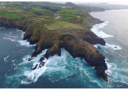
Figure 10. Ponta da Ajuda (Photograph by João Câmara, joaocamara.net).
Ponta da Ajuda features high and steep cliffs. Throughout its extent and at the base of the cliffs, columnar or prismatic jointing are observed. These basalt columns were formed in lava flows that moved over the slopes of Furnas polygenetic volcano (Moore 1990, 1991), which during the cooling and solidification processes of the lava, contracted causing the formation of fractures that are perpendicular to the cooling surface (Fig. 11).
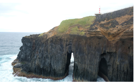
Figure 11. Columnar jointing of Ponta da Ajuda, and erosion arches (Photograph by João Câmara, joaocamara.net).
This peculiar geological structure has very good visibility from the sea, as well as the caves and arches produced by erosion of the columns, which are continuously eroded by the waves. At the top of the columns, hexagonal polygons or prisms can be observed, recalling of the well-known Giants' Causeway in Northern Ireland.
The rocks were formed by basaltic lava flows, and the most evolved lava flows at the top (with compositions slightly richer in silica, sodium and potassium), interspersed with some pumice deposits from the explosive eruptions, that occurred in the vicinity, were brought by the wind or by pyroclastic flows (Moore 1990, 1991). In some areas, it is possible to observe orange deposits that result from the alteration of these pumice deposits over time. On the west side of the Ponta da Ajuda, the rocks associated with the superficial lava flow show spherical jointing. This kind of structure, typical of old lava flows, in the western part of São Miguel Island, results from its alteration to more or less spherical shapes and with scales, which resemble onion peel (Fig. 12).
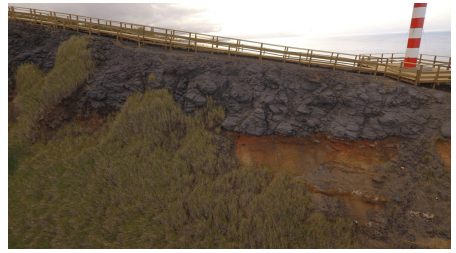
Figure 12. Spheroidal jointing on the top of the columnar jointing of Ponta da Ajuda (Photograph by João Câmara, joaocamara.net).
The parish council of Fenais da Ajuda valued the location with the trail inaugurated in December 2022, with a footbridge over Ponta da Ajuda, a swing to watch the sunset and a small viewpoint, to the west, to observe the basaltic columns. The works necessary for its classification as a protected area of local scope are being carried out by the City Council of Ribeira Grande, in accordance with Article 31 of Regional Legislative Decree no. 15/2012/A, of 2 April. This new geosite integrates the process of revision and (re)evaluation/assessment of the geological inventory of the Azores UNESCO Global Geopark.
Summary
The Azores UNESCO Global Geopark, from the beginning, was a different geopark, due to its geographic and tectonic settings, the fact that all islands are inhabited and also because of the marine geosites. It became obvious to the geopark team right from the start that there were important challenges, including the decentralized management of the geopark itself, the coexistence of the Azoreans with the volcanic landscapes and the associated risks, our isolated location that protects us and makes us an exotic territory, but more distant from decision-making centers and access to resources and support. That is why the success of the Azores Geopark is based on work with the partners on its various pillars of action.
The new approach brought by the establishment of the Azores UNESCO Global Geopark, through the work performed on the vectors of geoconservation (environmental), awareness and empowerment (social) and economy (geotourism), was one of the main engines for the affirmation of the archipelago as a territory of excellence for sustainability. This is one Geopark in an active volcanic and archipelagic territory with landscapes dominated by volcanoes that tell us their stories and by people that make them unique.