Introduction
Kachchh is the largest district of Gujarat and the second-largest district of India, situated at the extreme west of the Indian subcontinent. The place has had great significance from pre-historic times, especially because of its coastal location close to other nations, and major ports like Lothal were established during the Indus valley civilization. As the area shares its border with Pakistan, the region has witnessed major border disputes during the post-independence era. Thanks to its geographical position and rich geology, the area retains a significant role within the country, even though it is not very fertile in agricultural terms. The name Kachchh, sometimes spelled Kutch, comes from the word "Katchua or Kachbo," meaning a tortoise, because of the shape of the district on the map. The district capital is Bhuj.
The sedimentary succession of the region is Mesozoic and Cenozoic, resting on Precambrian basement (Biswas 1993). A fringe of Deccan volcanics is sandwiched between the Jurassic rocks in the north and Eocene sediments in the south on the coastward side. Limestone, shale, and sandstone are the most common rock types (Krishnan 1982). Recent marine deposits cover most of the northern region, where Jurassic outcrops. The coastal region is covered with marine and alluvial sediments, which are very well consolidated and appear as hard rock. During the Mesozoic, the Indian continent started to break away from the Gondwana supercontinent.
The Cenozoic sequence consists of both Paleogene-Neogene and Quaternary sediments. The Paleogene-Neogene sediments are of marine transgressive origin (Raju 2011), nearly 900 m thick and deposited within a post-rift marginal sag basin (Biswas 2016). Transgression commenced during the Late Paleozoic and continued till the Mid-Miocene. The sediments overlap the Deccan volcanic plateau. The Quaternary sediments represent both degradational and aggradational conditions. The former are characterized by incised valleys, strata terraces, and badland topography (Chauhan et al. 2021), and these include significant episodes of alluvial and colluvial fan deposits of Early Pleistocene age (Thakkar et al. 1999, 2001).
In this article, we analyze the potential of the various geological features in the Kachchh region. A significant part of this district is essentially a seasonal island, the Ranns of Great and Little Kachchh, which are inundated by water during the monsoon. Ranns is a flat salt marsh, and domal hill ranges dominate the landscape. The landmass can be categorized as 1. the Mainland Kachchh, 2. the eastern Wagad uplift, and 3. the northern island belts. The important geosites of Kachchh are widely distributed (Fig. 1).

Figure 1. Location of various geosites.
We use standard terminology, whereby elements of geodiversity with scientific value are termed geoheritage, which includes in-situ elements preserved at the place of their formation, called geosites, and ex-situ elements displaced from their place of origin (Brilha 2016). We understand the term geoheritage to include all geodiversity sites with exceptional scientific values, including features of geomorphology like landforms, petrology, mineralogy, paleontology, stratigraphy, structural geology, hydrology, and pedology (Brilha 2016). Landforms formed by groundwater are also considered as geomorphological features. All these kinds of geoheritage have educational, aesthetic, and cultural values.
All the abiotic elements of landscape viz. geological, geomorphological, hydrological, and pedological refer to geowealth or geoheritage (Kale 2015). A simplified classification of geowealth or geoheritage can be further classified as in Figure 2.
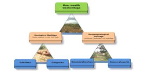
Figure 2. Simplified classification of Geoweath (Geoheritage).
The term 'geopark' deals with a territory that combines the protection and promotion of geological heritage with sustainable development (Zouros and McKeever 2004). The engagement of geoheritage, geopark, geodiversity, geotourism, and geoconservation is depicted in Figure 3.

Figure 3. Interrelations between geoheritage, geopark, geodiversity, geotourism and geoconservation. (After Williams et al. 2020).
In recent years, the evaluation and importance of geoheritage and its wise management have become significant trends (Brilha 2002; Zouros 2004, 2005; Panizza 2009; Zouros et al. 2009). Geoheritage also has a special relationship with the historical, cultural, aesthetic, and religious heritage of humanity (Brocx et al. 2007). But in the nineteenth century, because of urbanization and industrialization, these geological sites of immense importance began to be damaged by development. So, some awareness programs were developed for the protection of these sites (Page et al. 1999). Also, conservation of such geological sites, by improving their recreational and touristic potential for educational and economic purposes (Page 2018).
Proposed Mesozoic Geoheritage and Geomorphosites of Kachchh District, Gujarat
[Gh-1] Patcham Island Sections
Coordinates: 23˚ 55ʹ 48ʺN and 69˚ 48ʹ 39ʺE
The rocks of the Kaladongar Formation are Middle Jurassic, comprising a 472 m thick succession of shallow marine sediments, overlain by the Goradongar Formation representing a sub-littoral environment (Biswas 1977). The Kaladongar Formation is divided into three members, the Dingy Hill (or Kuar Bet), Kaladongar Sandstone, and Babia Cliff Sandstone members. Babia is the highest peak in the Kachchh district. The whole succession comprises alternating beds of shale and sandstone with some bands of calcareous siltstones and intra-formational conglomerates. There are three shell beds: 1. Turritella shell bed; 2. Rhynchonella shell bed; and 3. Bivalve shell bed. Besides, trace fossils are also reported from the region. A total of 38 beds are exposed in various sections.
[Gh-2] Habo Hill Sections
Coordinates:
- Kala Jar (stream) near Dhrang village, 23˚ 23ʹ 30ʺN and 69˚ 50ʹ 30ʺE
- Stream cutting near Habai village, 23˚ 21ʹ 10ʺN and 69˚ 51ʹ 19ʺE
- Stream cutting near Kotai village, 23˚ 23ʹ 24ʺ N and 69˚ 47ʹ 12ʺE
- Stream cutting 1km east of Fulae village, 23˚ 23ʹ 29ʺN and 69˚ 48ʹ 43ʺE
The Habo, a domal hill in the eastern part of Mainland Kachchh, is an east-west trending median anticlinal hill, showing quaquaversal dip, with a steeper north side and gentler south side. The older rocks at the center are surrounded by younger outer rocks. A maximum of 297 m altitude is attained. The east-west length is 16 km, and north-south is 6 km. The stratigraphy of the dome was studied by Wynne (1872), Spath (1933), Maithani (1968), Bhalla & Abbas (1978), and Kanjilal (1978). The Lodai Member of the Habo Formation consists of alternating beds of highly fossiliferous limestones, shales, and oolites, the Rudramata Member fossiliferous gypsiferous shale and flat pebble conglomerate, the Jhikadi Member a variety of sandstones, most of them fossiliferous, yellowish shales, and coral beds, with some conglomerate beds, the Dharam Member a variety of shales and limestones with flat pebble conglomerates, and the Black Limestone Member hard black-gray limestones (Kanjilal 1978).
[Gh-3] Jumara Hill Section
Coordinates: 23˚ 42ʹ 01ʺN and 69˚ 04ʹ 00ʺE
Jumara Hill is situated in the northern part of mainland Kachchh. The lithology can be divided into two broad groups, the Jhurio and Patcham formations representing a mixed carbonate-siliciclastic sequence, and the Chari Formation a siliciclastic-dominated sequence (Ahmad et al. 2013). The age is Middle to Upper Jurassic. The succession can be divided into 13 lithofacies including cross-bedded sandstone, massive sandstone, laminated sandstone, interbedded gypsiferous shale and siltstone, grey shale and thin-bedded sandstone, oolitic grainstone to conglomerate, bioclastic grainstone, bioclastic-lithoclastic grainstone, grapestone, and agglutinated grainstone, bioclastic-lithoclastic packstone, micro-bioclastic packstone/wackestone, bioturbated laminated wackestone to mudstone, pelagic mudstone with limestone (Ahmad et al. 2013). The sequence is rich in a variety of fossil assemblages. The total thickness of the exposed section is 300 m. The site is a natural museum of ammonites, bivalves, and coral limestones. Microfossils, such as foraminifers and ostracods, were also reported from the hill. The Banni plain bordering the geosite, offers beautiful scenery from a geotourism point of view.
[Gh-4] Jara Dome Section
Coordinates: 23˚ 41ʹ 00ʺN and 68˚ 58ʹ 00ʺE to 23˚ 45ʹ 02ʺNand 69˚ 00ʹ 00ʺE
The dome is situated on the northwest fringe of mainland Kachchh in the vicinity of the Banni plain in rugged topography, about 20 km from Dayapur. The dome has a diameter of 3 km and shows a prominent quaquaversal dip. The geology of the dome was first studied by Biswas (1977, 1978), Kanjilal and Prasad (1992), and Prasad (1998). It exposes the rocks of the Jumara and Jhuran formations. The Jumara Formation consists of thick beds of shale overlain by sandstone and shales of the Jhuran Formation. The Dhosa Oolite marks the boundary between the two formations. The shales are gypsiferous and carbonaceous with ferruginous nodules. The sandstones are oolitic and partly laminated. The shales are green, creamy to brown, the sandstones are white to light green, and the nodules are orange to red (limonitic) (Kanjilal and Prasad 1992). Well exposed sections are found along the deeply incised valley of the Jara River. In some places, the Mesozoic rocks are covered with Quaternary miliolite deposits, a calcareous rock composed of microscopic shells. The dome is dissected by several transverse faults, with a few discontinuous dikes at the central part of the dome, and they arose from the delimiting sills (Biswas 1993).
[Gh-5] Ukra Hill Section
Coordinates: 23˚ 47ʹ 06ʺN and 68˚ 50ʹ 43ʺE to 23˚ 45ʹ 30ʺN and 68˚ 51ʹ 02ʺE
The Ukra Hill is in the westernmost part of the mainland and wedges eastward (Biswas 1977, 1993). The thickness is about 35 m, where it exposes the Cretaceous shale and sandstones. The Bhuj Formation consists of marine to nonmarine strata that are divided into three Members: Ghuneri, Ukra Hill, and Upper members (Biswas 1977). It comprises glauconitic shale and sandstones that are rich in invertebrate fossil shells such as ammonites, belemnites, bivalves, and gastropods and logs of petrified wood. On the basis of trace fossils, ammonites and bivalves, Desai (2013) inferred the age as Aptian to Albian, whereas K-Ar dating gave an age about 105 ±1.3 to 107 ±3.4 Ma. The deposit can be described as a tongue in a deltaic sequence signifying a transgressive break of progradation. Glauconite in the Ukra Shale suggests a littoral to neritic environment of deposition under reducing conditions (Rathore et al. 1999).
[Gh-6] Keera Dome Section
Coordinates: 23˚ 36ʹ 00ʺN and 69˚ 14ʹ 00ʺE
The dome is named after Keera village, situated about 50 km northwest of the district headquarters, Bhuj. A c. 210 m thick succession is exposed at the dome, comprising the Jumara and Jhuran formations. The rock type is broadly vari-colored shales with ferruginous nodules, alternating with limestones and sandstones of Middle to Late Jurassic age. Talib et al. (2012) divided the exposed sections of the Jumara Formation into four informal members named A, B, C, and D. Member A consists of golden yellow to reddish-brown limestones, hard and compact in nature with oolites and an abundance of ammonites. Member B consists of two limestone beds, brownish to greenish-yellow in color, of which the upper one contains belemnoids. Member C has one gypsiferous shale bed at the base, and two limestone beds at the top, which is barren of fossils. The topmost member is "D," displaying brown to reddish-brown limestone, which is fossiliferous. The Jhuran Formation represented by fine to coarse-grained sandstones, but is devoid of fossils and.
[Gh-7] Ler Dome Section
Coordinates: 23˚ 10ʹ 30ʺ N and 69˚ 41ʹ 30ʺE to 23˚ 12ʹ 30ʺN and 69˚ 45ʹ 00ʺE
The Ler Dome (Fig. 4) is about 10 km southeast of Bhuj town. The name comes from Ler village, which is 200 m northeast of the dome, and is well connected to Bhuj town by a local bus route. The dome exposes the Jumara and Jhuran formations. The sequence consists of limestone, shale, sandstone, and conglomerates. Tiny to large shells are visible in the limestones. The Jhuran Formation is not well exposed in the area because of the thick cover of alluvium. The Ler Dome, a doubly plunging anticline, covers about 28 km2, being 7 km long and 4 km wide. As a whole, the hill shows differential quaquaversal dip, gentle towards the south and steep towards the north. Hence it is referred to as a dome. There are several minor faults passing through the dome, but displacement has not been observed. One significant fault, the Katrol Hill Fault, passes to the north of the dome, having an E-W trend known. Bivalves and ammonoids are reported from the dome (Agrawal et a. 1978) along with microfossils like foraminifera (Talib et al. 2007) and ostracods.
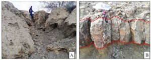
Figure 4. The Ler Dome. A) 6 m thick succession of nodular shale. B) The Dhosa Oolite Member (Oxfordian), a regional marker bed. C) Ferruginous sandstone dyke near road cutting, Ler village.
[Gh-8] Deep gorge of Khari River
Coordinates: 23˚ 15ʹ 37ʺN and 69˚ 37ʹ 29ʺE
Gorges are deep, narrow valleys formed when a river carves through hard bedrock. The river Khari originates from the Katrol Hill range and flows towards the Bhuj area (Thakkar et al. 2001). It has a maximum length of 50 km, with a total catchment area of 113 km2. The gorge is popularly known as the Grand Canyon of the Kachchh district, located 3 km west of Bhuj city, on the Bhuj-Kakodi road. The gorge is about 15–20 m deep. It is especially well developed near Khari Bridge, where the sandstone bedrock is incised by a narrow gorge (Fig. 5). The distinctive erosional terraces indicate relative uplift of the landform, followed by erosion. The Bhuj sandstone is composed of predominantly medium to coarse-grained sandstone that gradually grades into siltstone. There are a few bedrock gorges in the Khari valley and adjacent area, the most of which are located within the Katrol hill range, while the Khari gorge is formed on the flat rocky bedrock surface of the downthrown block of KHF (Thakkar et al. 2021).
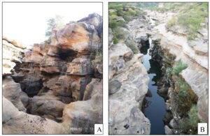
Figure 5. Deep gorge of the Khari River. A) Photo taken within the gorge, B) photo taken from the Khari Bridge.
[Gh-9] Rudramata Reservoir Cliff Section
Coordinates: 23˚ 21ʹ 47ʺN and 69˚ 41ʹ 65ʺE
Well exposed sections can be observed during the post-monsoon period all along the Rudramata Reservoir cliff just below the Rudrani Bridge (Fig. 6). The rocks belong to the Middle Jhuran Formation, and the lithology varies from sandstone to siltstone, which is carbonaceous to ferruginous. The sandstones occur in a variety of colors from ochre-yellow to reddish-brown to black. The section is significant because of well exposed soft sedimentary structures, including slump folds, clastic dykes, syn-sedimentary faults, and convolute bedding (Kale et al. 2016). A number of burrows are found in the soft sediments, including horizontal burrows formed by suspension feeders and vertical burrows, typically Skolithos, by deposit feeders.

Figure 6. Rudramata Reservoir. A) The reservoir. B) Dried Khari River valley during the month of February.
[Gh-10] Tapkeshwari Temple Rock Cave
Coordinates: 23˚ 10ʹ 54ʺN and 69˚ 40ʹ 00ʺE
The Tapkeshwari Temple (Fig. 7B), on the scarps of Tapkeshwari Hill, is part of the Katrol Hill range, located south of Bhuj town (Thakkar and Kar 2017). The name “Tapakeshwari” means trickling water. According to legend, the Hindu goddess Tapkeshwari was created from drops of water that fell from a stone, and in this form, she married Shiva and gave birth to Ganesh. The exposed upper Jhuran (Katrol) Formation here consists of alternating beds of sandstone and shale. The sandstones are ferruginous, and tend to be concentrated along the cavities formed by rock fractures. Adjacent to the temple, there is a natural cave that was formed by wind erosion by the removal of soft sediments (Fig. 7A). This is the geological feature that grabs the attention of most tourists. Erosional rings are found on the cave wall, along with sedimentary structures like cross-stratification, hummocky cross-stratification and herringbone cross-bedding, etc. Other post-depositional structures are also found near the site, including a normal fault as part of a horst and graben structure that indicates local extension.
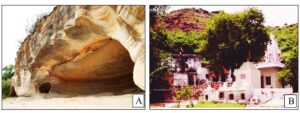
Figure 7. Tapkeshwari Temple rock cave. A) Rock cave on top of the hill near the Tapkeshwari Temple. B) Tapkeshwari Temple.
[Gh-11] Dhinodhar Hill Volcanic Plug
Coordinates: 23˚ 27ʹ 01ʺN and 69˚ 20ʹ 07ʺE
Dhinodhar Hill is an ancient volcanic plug formed by cooling and solidification of molten silicate magma and raised over the local sandstone topography (Figure 8). It shows a nearly vertical tabular dyke-like intrusion with well-developed columnar structure in the basalt. Broadly, it is like a ring dyke and/or cone sheet open towards the east with a central crater-like depression. It is not a vent itself but an eroded vent of the sub-volcanic intrusion emplaced during the time of the Deccan lava flow of Late Cretaceous age (69–65 Ma). The lithology is a fine-grained mafic rock with dark-colored minerals, basaltic, and without significant phenocrysts. The maximum height is 386 m, which provides a beautiful landscape from the top of Dhinodar Hill, including the scenic beauty of the Great Rann and Chari Dhand wetland. The hill is covered with a wide variety of plants, many of which have ethnomedicinal value (Rabari 2016). The site is well known as a trekking destination.
From the cultural point of view, the Dhormanath Shrine, at the top of the highest peak, is a small dome-shaped structure, made from limestones, mud-plastered with cement, and has been slightly damaged. The shrine was patronized by Brahma-Kshatriya Shethh Sundarji Sivaji in 1821.
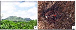
Figure 8. Dhinodhar hill volcanic plug; A) scenic view, and B) aerial view taken from Google Maps.
[Gh-12] Dholavira Fossil Park
Coordinates: 23˚ 53ʹ 19ʺN and 70˚ 12ʹ 50ʺE
The fossil wood park of Dholavira is a great site for paleontologists and students. The park is about 10 km northwest of Dholavira, famous for its archaeological sites, preserving the Indus valley civilization (Harappan civilization), which existed from 3000–1800 BCE, and is listed as a UNESCO World Heritage Site. The rocks belong to Khadir Formation, comprising sandstone, shale, and limestones, dated as Middle Jurassic (Aalenian to Bathonian). At the entrance gate, there is a big ammonite sculpture that grabs the attention of tourists. Fossils and large boulders of sandstone lie above a rectangularly jointed massive bed of sandstone. The site is of particular importance because of the large petrified tree trunks, 8–10 m long and 0.5–1 m in diameter (Fig. 9A, B). The fossil wood is fibrous but cells are not clearly observable. Similar plant fossils have been reported from the Jaisalmer district, Rajasthan. There is a flamingo lake near the park (Fig. 9C), which resembles the salt lakes of Bolivia. A great number of flamingos arrive during March to breed. The roads leading to the park are narrow and bumpy.
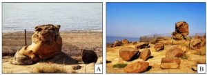
Figure 9. Dholavira fossil park, (A, B) examples of fossil tree trunks; C) flamingos in lake near Dholavira Fossil Park.
[Gh-13] Fakirwari Petrified Wood
Coordinates: 23˚ 12ʹ 12ʺN and 69˚ 37ʹ 43ʺE
There are several petrified wood logs (Fig.10) that require conservation found 4–5 km east of the Bhuj-Mandvi road (NH 47). The petrified wood occurs in the Bhuj Sandstone, which is of Cretaceous age. Here silica that had been released from sandstones has mostly replaced the cellular structure of the ancient plant.
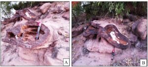
Figure 10. A and B) Petrified tree trunks in the Bhuj sandstone at Fakirwari.
Proposed Cenozoic Geoheritage and Geomorphosites of Kachchh District, Gujarat
[Gh-14] Mata-no-madh Cliff Section
Coordinates: 23˚ 32ʹ 30ʺN and 68˚ 57ʹ 10ʺE
Well-developed sections are exposed in road cuttings on the Bhuj-Lakhpet road, west of Mata-no-madh village, and along the valley of the Madhawali River. The rocks belong to Mata-no-madh Formation, 20 m thick and of Eocene (Lutetian to Bartonian) age based on pollen and spores (Saraswati et al. 2014), consisting of green shale, carbonaceous shale, mudstone, clay, weathered basalt, and lignite. These lie over the Deccan traps, and the environment of deposition was fluvial to lacustrine (Srivastava and Singh 2017). The site is being degraded rapidly, especially because of lignite mining which is extending rapidly. Before complete destruction, it should be controlled by the government.
[Gh-15] Naredi Cliff Section
Coordinates: 23˚ 39ʹ 49ʺN and 68˚ 40ʹ 38ʺE
The site is named after Naredi village, and the stratotype of the Naredi Formation is exposed along the Kakdi River valley near the village. It is about 40 m, and overlies the Deccan Traps. The rock types are green shale, red shale, mudstone, limestone, sandstone, and laterite. Glauconite in the sediment is associated with the transgressive system tract and confirms an oxygen minimum zone in a marine environment (Sahay et al 2015). Extensive laterite mining is devastating the natural rock sections, so the government, as well as the environmental protection agencies, should pay attention to the preservation of the cliff.
[Gh-16] Fulra Limestone Section
Coordinates: 23˚ 42ʹ 45ʺN and 68˚ 46ʹ 48ʺE
The Fulra Limestone Formation, named after Fulra village, borders the Harudi Formation in a semi-circular pattern and represents the most extensive deposit of the Palaeogene carbonate platform of Kachchh. In the north, it starts from Lakhpat and extends southward in a semi-circular pattern towards Harudi. The section is situated at the extreme west of the Kachchh basin, and is well exposed on the southern flank of Babia Hill, about 1.5 km from Fulra village. The limestone-dominated formation is divided into seven lithofacies over about 15 km, varying from different types of grainstone to packstone (Srivastava et al. 2019). The Formation contains a wide variety of faunal assemblages, including large and small benthonic and planktonic foraminifers, as well as bivalves and echinoids (Kachhara et al. 2011; Saraswati et al. 2000; Srivastava et al. 2008). Calcareous nanofossils and calcareous algae are also reported (Rai 1997; Singh et al. 2010; Singh et al. 1991). Extensive exploration of these limestones by cement factories, without any precautionary measures, may cause the collapse of the cliffs and sections.
[Gh-17] Sandhan Formation
Coordinate: 23˚ 01ʹ 29ʺN and 69˚ 59ʹ 44ʺE
The Sandhan Formation of the Kachchh basin is dominated by siliciclastic rocks of Pliocene age, and overlying Middle Miocene rocks (Biswas 1992). The thickness is about 292 m, and well-developed sections are exposed along the cliffs and banks of the Kankawati and Kharod rivers. The lower part of the Sandhan Formation is a conglomerate marking an unconformity over the Chhasra Formation. The upper part of the formation is more significant because it is a paleosol horizon over which sub-Recent rocks lies. The depositional environment is interpreted to be supra-littoral to deltaic or foreshore environment (Biswas 1992).
[Gh-18] Golay River Section, Ber Moti Village
Coordinates: 23˚ 05ʹ 02ʺN and 23˚ 28ʹ 07ʺE to 68˚ 35ʹ 02ʺN and 68˚ 37ʹ 02ʺE
Ber Moti is a village situated in the extreme west of the Kachchh district and comes under Abdasa Taluka. The Golay River flows east of the village. The village of Maniyar has an old fort, called the Maniyar fort, located on a hilltop 68 m above sea level. A well-developed section is exposed along the river cliff with rocks of Oligocene age. The basal section consists of greenish glauconitic siltstones underlain by ochre to yellow colored limestone containing foraminifers. The Bermoti Member is 10 m thick and well developed along the river section, southeast of Ber Moti village. It consists of red to brown colored argillaceous sandstone at the base and coralline limestone at the top. The disconformable contact between the Fulra Limestone and Maniyar Fort formations is well exposed along the Golay River section near Ber Moti village.
Classification of the Geoheritage Sites
Having reviewed the 18 geoheritage sites of Kachchh Province, we proceed to classify them according to their geoheritage values. In doing so, we follow a four-step process (Figure 11), beginning with a literature review, which has been extensive, as noted above and in the reference section. The next step consists of fieldwork, which includes characterization of existing geodiversity sites, the degradation risk of those sites, and proposal of new potential geoheritage sites. Following this inventory phase, we move to quantitative assessment, based on a number of criteria.
The geoheritage potential of the sites can be based on a range of accepted numerical assessment methods given by Pralong and Reynard (2005), Pereira et al. (2007), Bruschi and Cendreno (2009), Bollati et al. (2013), and Brilha (2016). Here, we mostly follow the numerical procedures from Brilha (2016).
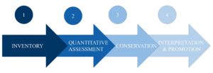
Figure 11. Various steps to establishing geoheritage sites.
Scientific values (SV): Seven criteria are provided by Brilha (2016) for the quantitative assessment of scientific value:
- Representativeness: how accurately a geodiversity site can illustrate geological elements and processes.
- Key locality: the suitability of the geodiversity site as a reference or model for stratigraphy, paleontology, petrology, mineralogy, etc.
- Scientific knowledge: published scientific knowledge about the geosite, represents the value given to the geodiversity site by the scientific community.
- Integrity: conservation of the main geological element of the geodiversity site; the higher the integrity, the higher the scientific value.
- Geological diversity: the number of different geological elements with scientific interest
- Rarity: the number of similar geodiversity sites present in the study area.
- Use limitations: the presence of any hurdle, which may create problems in the regular scientific use of the sites.
The highest weighting is given to representativeness at 30%, followed by key localities at 20%, integrity and rarity at 15%, use limitation at 10%, and scientific knowledge and geological diversity at 5%. Each criterion of scientific value consists of 5 points as a whole, and geodiversity sites can be ranked as 1, 2, and 4 according to their value indicated by the criterion (Brilha 2016).
Potential Educational value: There are 12 criteria for the assessment of the geodiversity site for potential use in educational purposes. These are as follows:
- Vulnerability: the presence of geological elements in the geodiversity sites that are prone to be destroyed by anthropogenic activity. The higher the vulnerability, the lower the educational value.
- Accessibility: how easy it is to reach the geodiversity sites using different means of transport. The easier and quicker the higher the educational value.
- Use limitations: the presence of any hurdle, which may create problems for educational activities.
- Safety: how risky it is for students during the fieldwork. The lower is the risk, the higher is the educational value.
- Logistics: the presence of facilities for students during fieldwork, such as accommodation, food, toilets, etc. The more facilities the higher the educational value.
- Population density: the population density in the nearby area, which may provide students for educational activities. The higher the density the higher is the educational value.
- Other associations: the presence of any other natural and cultural elements in the vicinity of the geodiversity sites, which may add multidisciplinary value to the sites. The more the association, the higher is the value.
- Scenery: the natural scenic beauty of geodiversity sites, which may grab students' attention to encourage them visit study in the field.
- Uniqueness: the special qualities of the geodiversity sites that are not seen anywhere else. The more special and unique, the higher the educational value.
- Observation conditions: the easier it is to observe different elements of the geodiversity site, the higher the educational value.
- Didactic potential: use of the site by various levels of students for educational purposes. The wider the range of levels, the higher the educational value.
- Geological diversity: the number of geological elements at the geodiversity site. The higher the number, the higher the educational value.
Each of the criteria consists of 10 points with a maximum of 4 points that can be given to a geodiversity site. The educational potential is the sum of all the points of the 12 criteria. In the case of potential educational value, maximum weighting is given to the didactic potential, at 20%.
Potential touristic value: Thirteen criteria are available for the assessment of potential touristic value. The first ten criteria are the same as those used to evaluate educational value, and so are not repeated; only the last three are newly added. These are as follows:
- Interpretative potential: the ease with which the general public, that is, people with a non-geological background, can understand the various features of the geodiversity sites. The easier it is, the higher the touristic value.
- Economic level: the economic standard of the people living near the site, which in turn suggests how many people will visit the site.
- Proximity to recreational areas: nearby well-known touristic places surrounding the geodiversity site may increase the potential touristic value.
Each criterion here has a total of ten points, and one site can be assigned 1 to 4 points. The aesthetic components of a geodiversity site have more effect on the potential touristic value. Aesthetic components include, for example, geomorphological components that can be observed and understood by the general public. In addition, good facilities at the site and natural scenic beauty also have great significance.
Degradation risk: The degradation risk reflects natural and anthropogenic factors responsible for the weathering and erosion of the site. The degradation risk drives future blueprints around development of a site or even of a geo-corridor. Brilha (2016) suggested five criteria to rank the potential degradation risk of a geodiversity site.
- Deterioration of geological elements: the likelihood of degradation of the geological elements at the site because of natural and anthropogenic causes. Natural causes include the resistance of rock minerals and fossils to weathering, and anthropogenic causes include activities like tourism, agriculture, urbanization, vandalism, etc.
- Proximity to areas/ activities with potential degradation risk: activities such as mining, industrial facilities, recreational areas, roads, urban areas, etc.
- Legal protection: legally protected areas are protected by any private party or by the government. Included restrictions are by legal owners, fences, entrance fees to the area, mining sites that may not support visitors' entry.
- Accessibility: access to the site for any reason, without any restriction (disabled persons not included). The more readily accessible to the general public, the more will be the degradation risk.
- Density of population: population density near the site may cause deterioration of the site due to unseemly activities like vandalism, theft, etc.
Results and Discussion
From our assessment, most of the geodiversity sites of the Kachchh district have good potential in most aspects to be considered as geoheritage (Table 1). Taking into account scientific value, we can find that most of the geodiversity sites have a scientific value of more than 60% except one (Figure 12). As we know, representativeness holds a 30% score, so there are six geodiversity sites with the highest points in representativeness, and most of them have a half-point. A key locality holds 20% of the score, and most of the geodiversity sites have half points in terms of being key localities. In terms of scientific value, all the geodiversity sites have significant potential. The only geodiversity site with a scientific value of less than 50% is Gh-13, Fakirwari petrified wood; this is because of the very small scale, which reduces the significance of the site, and weathering washed out almost half of the petrified wood. Another possibility is that the lack of knowledge among the people about petrified wood is another factor contributing to low potential.
Table 1. Classification of the geoheritage sites of Kachchh, following the terminology of Brocx and Seminiuk (2007).
S. N. | Geoheritage sites | Scope | Scale |
Gh-1 | Patcham Island Section | Petrological site, Stratigraphical site, Structural site, Palaeontological site, | Large scale |
Gh-2 | Habo Hill sections | Petrological site, Stratigraphical site, Structural site, Palaeontological site, Palaeoclimatological site. | Large scale |
Gh-3 | Jumara Hill section | Petrological site, Stratigraphical site, Structural site, Palaeontological site, | Large scale |
Gh-4 | Jara Dome section | Petrological site, stratigraphical site, geomorphological site, paleontological site, | Large scale |
Gh-5 | Ukra Hill section | Petrological site, Stratigraphical site, mineralogical site (For glouconite), paleontological site. | Large scale |
Gh-6 | Keera Dome section | Petrological site, stratigraphical site, palaeontological site | Large scale |
Gh-7 | Ler Dome section | Petrological site, stratigraphical site, palaeontological site, Structural site | Large scale |
Gh-8 | Deep gorge of Khari River | Geomorphological site, structural site, petrological site. | Small scale |
Gh-9 | Rudramata Reservoir cliff section | Petrological site, stratigraphical site, geomorphological site, structural site. | Medium scale |
Gh-10 | Tapkeshwari Temple rock cave | Petrological site, geomorphological site, structural site, cultural site. | Small scale |
Gh-11 | Dhinodhar Hill volcanic plug | Volcanological site, structural site, petrological site | Large scale |
Gh-12 | Dholavira fossil wood park | Palaeontological site, petrological site | Small scale |
Gh-13 | Fakirwari petrified wood | Petrological site, stratigraphical site, palaeontological site. | Small scale |
Gh-14 | Matanomadh cliff section | Petrological site, stratigraphical site, Palaeontological site | Medium scale |
Gh-15 | Naredi cliff section | Petrological site, mineralogical site, stratigraphical site, palaeoclomatological site | Medium scale |
Gh-16 | Fulra limestone section | Petrological site, stratigraphical site, palaeontological site. | Medium scale |
Gh-17 | Sandhan Formation | Petrological site, stratigraphical site, (palaeo)pedological site. | Medium scale |
Gh-18 | Golay River section | Petrological site, geomorphological site, stratigraphical site, cultural site. | Medium scale |
Figure 12. Assessment of the 18 geosites of Kachchh Province, Gh-1 to Gh-18, for scientific value. Percentage of the scientific value (left) and weighting of various criteria of scientific value (right).
The next important assessment is on potential educational value. Out of the 18 geodiversity sites, all have more than 60% educational value except five (Figure 13). Out of the five, Gh-5 and Gh-14 have a potential of around 58%, but Gh-1, Gh-11, and Gh-16 have potential educational value more than 50% but less than 60%. The decreased potential is mainly due to poor accessibility to the site, no other association of cultural, architectural site nearby, and low population density around the site in terms of potential visitors and services for visitors. Most sites also lack significant scenery around. In this assessment, didactic potential holds maximum weighting and the interesting fact is that all the geodiversity sites have the same didactic potential. So, all the geodiversity sites have good potential to serve as educational sites.
Figure 13. Assessment of the 18 geosites of Kachchh Province, Gh-1 to Gh-18, for educational value. Percentage of educational value (left) and weighting of various criteria of educational value (right).
In the case of potential touristic value (Fig. 14), out of the 18 geodiversity sites, eight score less than 60%. But seven out of the eight score more than 50%, except Gh-1, which scores around 46%. The low score of Gh-1 is because it lacks a score for proximity to recreational areas, and has a very low score in the criteria of accessibility, population density, other associations and scenery. The main drawback that leads to low scores in potential tourist value of some of the geodiversity sites is poor access. Although some of the geodiversity sites score less than 50%, they can be developed as good tourism spots with some developmental work.
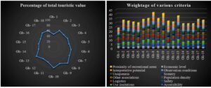
Figure 14. Assessment of the 18 geosites of Kachchh Province, Gh-1 to Gh-18, for touristic value. Percentage of the touristic value (left) and weighting of various criteria of touristic value (right).
The final and most important assessment is on degradation risk. Unlike the other assessments, here the higher the score, the greater the risk of degradation, as shown in Figure 15. Gh-1 has the lowest score followed by Gh-2, which means that these geodiversity sites are much less prone to degradation risk, because there are no proximal degradation risks such as heavy erosion or mining. The accessibility of these geodiversity sites is also poor. Further, the population density around these geodiversity sites is very low. On the other hand, Gh-13, Gh-15 and Gh-18 have high scores, 80%, indicating very high risk of degradation. This high score is mainly due to nearby degradational risks, easy accessibility and high density of population. The degradation risk can be avoided by following geoconservation guidelines provided by IUCN World Commission on Protected Areas (WCPA). Besides, in this work authors have provided some suggestions for geoconservation (Fig. 15).
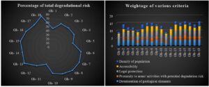
Figure 15. Assessment of the 18 geosites of Kachchh Province, Gh-1 to Gh-18, for degradation risk. Percentage of degradation risk (left) and weighting of various criteria of degradation risk (right).
Geotourism promotion: In simple words, geotourism is geological tourism. Like tourism, geotourism involves visiting, learning, evaluating, and interpreting the geological features (Dowling 2011). The gradation of tourism into geotourism (Fig. 16) narrows down with increasing depth of knowledge and decreasing entertainment factors. The points below may help promote geotourism:
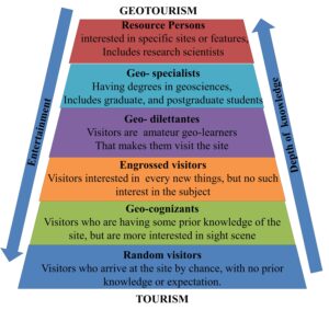
Figure 16. Gradation between the tourism and geotourism sectors.
- Promotion through education: Geotourism and geoeducation are two related terms. Education is the only and primary medium that can be used for the promotion of geotourism. For this, necessary steps are the inclusion of geoheritage sites in both primary and secondary level education as examples with attractive images. To make it more interesting, geoeducation should be integrated with other disciplines. For example, we can take fault lines as sites for most of the ancient civilizations as rivers flow along them. Also fault lines are associated with most of the mineral deposits as well as natural disasters such as earthquakes. Such small steps can be taken to promote geodiversity sites.
- Promotion through film tourism: Film tourism is an advanced as well as unique practice for the promotion of geotourism. We have seen many eye-catching sites in different movie scenes; in the context of India, most of the Bollywood songs are shot around those sites. Nowadays, movies and web series are watched by people of all ages, so film tourism can be used an effective medium to promote geotourism.
- Government websites: Every state has tourism websites showing information about tourist sites and attractive photographs, but these do not cover all the geodiversity sites. So, government tourism websites should contain all the information about each and every geodiversity site of the state along with all related information such as connecting roads, availability of all logistic facilities and nearby tourist places.
- Blogs and articles: Government officials from tourism departments as well as any individual can post articles about geodiversity sites, describing their unique features and the history of formation. Publishing articles and blogs can be important practices for geotourism promotion.
- Star influencers: In India, Bollywood stars and cricketers are the biggest influencers. For example, Bollywood actor Amitabh Bachan is an ambassador for the promotion of Gujarat tourism. Likewise, governments can appoint such influential persons to promote geotouristic sites.
- Social media: Social Media Marketing is marketing in social media like Facebook and Instagram. Nowadays, nearly everybody is more or less connected with social media. So promotion of geotourism such as posting banners and writing articles will definitely help to increase geotourism.
- Commercial ads: Tourism is based on the integration of features such as attraction, accommodation, transportation and associated businesses. These services are generally operated by private agencies. So along with the commercial ads of their agency they should be directed by the government to promote geodiversity sites.
- Addition of more activities to the site, attractive to younger people, such as trekking, caving, parading, flying fox, rock climbing, bungee jumping, etc. Our country is so naturally blessed that it is filled with diverse topography, like hillocks, plateaus, mountains, and caves. The diverse topographies in turn make the geoheritage sites. So, adding such sports activities to geotourism will help in promotion.
- Constant updating of the above-mentioned recommendations: the websites, banners, additions of new features, and development of new infrastructure in the geoheritage sites should be constantly updated.
Appeal for geoconservation: In the 1990s, for the first time, the IUCN World Commission on Protected Areas (WCPA) provided some guidelines for the management of protected areas. However, no such importance was given for the conservation of geoheritage. Approaches of working professionals and visitors towards geoheritage are clearly mentioned in the geoconservation guidelines. Sharples (2002) described geoconservation as "the forgotten half of nature conservation". This statement reminds us that a great deal of attention has been paid to biological diversity, but little to geological diversity. It is important to emphasize that biodiversity directly and indirectly depends upon geodiversity. So, the incorporation of both biodiversity and geodiversity leads to the successful conservation all nature.
There are proper guidelines for geoconservation in protected and conserved areas, published in 2020. These include 22 recommendations in nine sections, to which we add a further nine practical suggestions relevant to the geosites discussed in this paper.
- During field visits, we noted that reservoirs had been dug for water storage on some of the geodiversity sites. These should be prohibited by the local administration.
- There are some areas where mining activity is proceeding for limestone and other minerals. These activities generate resources, money and jobs, but should be properly regulated without destroying important elements of the geodiversity sites.
- Also, there are many roadways and canals cut through the geodiversity sites, damaging them and many of their key features. Buffer zones should be demarcated around the geodiversity sites by the government for their protection and the roadways and canals should be joined through an alternative route.
- The remaining parts, along road cuttings and canal cuttings are more prone to weathering and erosion, and the walls should be covered properly with synthetic mats and retaining walls should be constructed to prevent collapse.
- Most of the sites yield a huge variety of Jurassic fossils, but these are being lost to uncontrolled excavation, excessive sampling. Crushing of exposed fossils should be taken care of by specific guidelines and sign boards.
- Proper sign boards should be installed at different places in the geodiversity sites and proper instructions should be published on the geotourism websites, indicating proper behavior and /or activities for visitors during their visits.
- Key parts of the geodiversity sites with the most sensitive geo-elements should be protected by fencing and government regulation.
- Geoconservation workers should be hired by the local government to raise awareness among local people about the importance of geological elements and to guide visitors.
- Although some anthropogenic activities cannot be avoided, regulating those with proper guidelines for geoconservation is also an important aspect. It cannot be ignored that important geologic elements should be preserved for future generations.
Conclusion
After the flourishing of biotourism, now it is time to popularize geotourism by identifying rocks and minerals and analyzing geology and geomorphology. We are keen to provide students and laymen with significant knowledge about the geological aspects of Kachchh district, which will help the government to acquire some revenue through geotourism through the implementation of some development strategies. Also, safeguarding these valuable sites is a duty not only of the government bodies but also of every citizen.
Kachchh is the right shoulder of the Indian subcontinent. The place is full of fascinating, rare and well exposed geological as well as archaeological features. These unique features attract geologists and archaeologists from all over the world to carry out their research. The place preserves a unique history of the earth from the Jurassic to the present. From this assessment, it is proved that most of the geodiversity sites have unique potential and should be accorded the status of geoheritage sites.
Acknowledgments
We acknowledge Mr. Lalit M. Upadhayay, an independent geologist, for guiding us during our field visit and local personnel for providing valuable information regarding the sites.