Introduction
The Regional Natural Park of the Monts d'Ardèche, located in south-eastern France on the eastern range of Massif Central, obtained the status of UNESCO Global Geopark in September 2014. At this point, it became integrated with the network of 177 UNESCO Global Geoparks throughout the world. It is the fifth labeled geopark in France out of the seven in this country and the only one with a clear volcanic heritage (39 of the 61 geosites; Fig. 1). The UNESCO Global Geopark label promotes territories with international geological significance, and which combine protection, education, geotourism and sustainable development by involving local communities and various actors. Amongst its many commitments, the Monts d’Ardèche UNESCO Global Geopark is strengthening its involvement in scientific research and outreach to better understand and promote its young and old volcanic heritage. The Geopark addresses several scientific questions, for example, magmatic processes, eruptive dynamics, morphological evolution of landscapes, and relationships between humans and volcanoes. We develop here three significant examples of sites which fully illustrate these different topics.
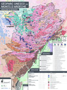
Figure 1. Geological simplified map of the Monts d’Ardèche UNESCO Global Geopark (modified) with the position of the volcanic geosites (large dots). Geosites inside framed areas are presented in this paper.
Monts d’Ardèche UNESCO Global Geopark has been associated with volcanism for 10 Ma (million years). The volcanic activity is diverse, providing many different landscapes including strombolian craters, phonolite extrusions, maars, dykes, necks, and basaltic flows, all of which have shaped the landscape we observe today (Klee 2022). Three major volcanic episodes have been identified in Monts d’Ardèche and these created different volcanic provinces.
The first episode created the Eastern Velay volcanic province. It began (10-8 Ma) in Mont Mézenc-Mont Gerbier with the building of a vast plateau made of piled basaltic to trachy-andesitic lava flows. During the second episode (8-6 Ma), trachytic to phonolitic magmas created intrusions and extrusions (domes and peaks locally called “Sucs”). These forms and the later intense erosion have shaped a unique and scenic landscape, including one of the largest phonolitic massifs in Europe. The best-known places are Mont Gerbier de Jonc, easily identifiable with its typical sugarloaf shape which hosts the source of the Loire River, and Mont Mézenc, which reaches an altitude of 1753 m (Fig. 2).
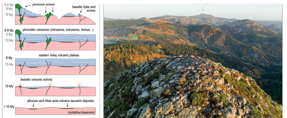
Figure 2. A) Stages in the construction of the central part of the Eastern Velay volcanic province (Mézenc-Gerbier massif and Hautes Boutières) (CAD E. Defive). B) The Mont Mézenc, also called the Cévennes Giant: a view from the top of the Mont Gerbier de Jonc (in the foreground) to the north (photo B. Gremen).
At the same time (8-6 Ma), another volcanic province formed, the nearby massif of Coiron, which is characterized by more fluid basaltic lavas fossilizing the paleo-course of the Ardèche River which ran towards the Rhône Valley. The landscape exhibits various features here including intruded dykes, volcanic necks, and lava flow stacks (Fig. 3).
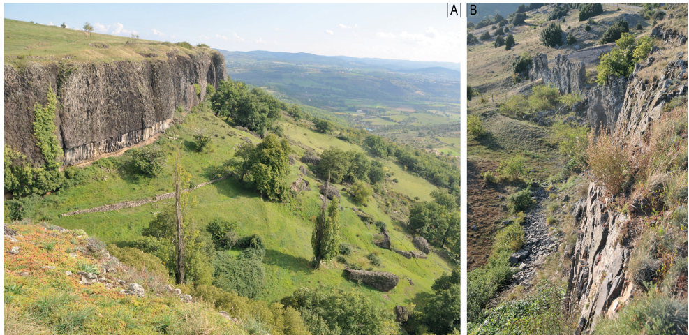
Figure 3. Volcanism of the Coiron. A) Mirabel sector: the lava flow with regular columnar jointing and thick entablature overlies an alluvial sheet of the palaeo-Ardèche River (ochre level at the bottom). Megablocks fallen from the entablature are scattered on the slope below. B) Basaltic dyke at the Coulet de la Soulière (photos E. Defive).
The last major period began some 200,000 years ago and created the Bas-Vivarais volcanic province (named also the “Ardèche Young Volcanoes”) (Fig. 4). These eruptions have generated almost perfect strombolian volcanoes, still easily visible in the landscape despite the vegetation cover (Fig. 5A). Most of them are relatively young, aged between 40,000 and 12,000 years ago depending on the dating methods used. The oldest ones were contemporary with Neandertal occupation, then with Homo sapiens prehistoric settlements in Ardèche, notably marked by the Chauvet cave mural drawings that are known to be part of the oldest in the world (36,000 years) and certainly one of the first chef-d’œuvres (Pastre et al. 1994; Sanzelle et al. 2000; Raynal & Defive 2019 and references herein). While cooling down, lava flows originating from these volcanoes created basalt columns showing a remarkable prismatic shape (columnar jointing; Fig. 5B), well described by the pioneers of volcanology: Faujas de Saint-Fond (1778), Giraud-Soulavie (1780) and Poulett-Scrope (1827). The longest lava flow is about 21 km long, starting at the Ray-Pic waterfall and ending at Pont-de-Labaume. Among the young volcanoes, there are a number of maars, created by intense and violent phreatomagmatic activity. The largest one in Monts d’Ardèche is the Vestide du Pal, with a diameter of 1.7 km and a circumference of over 5 km, which is one of the largest maars in continental Europe.
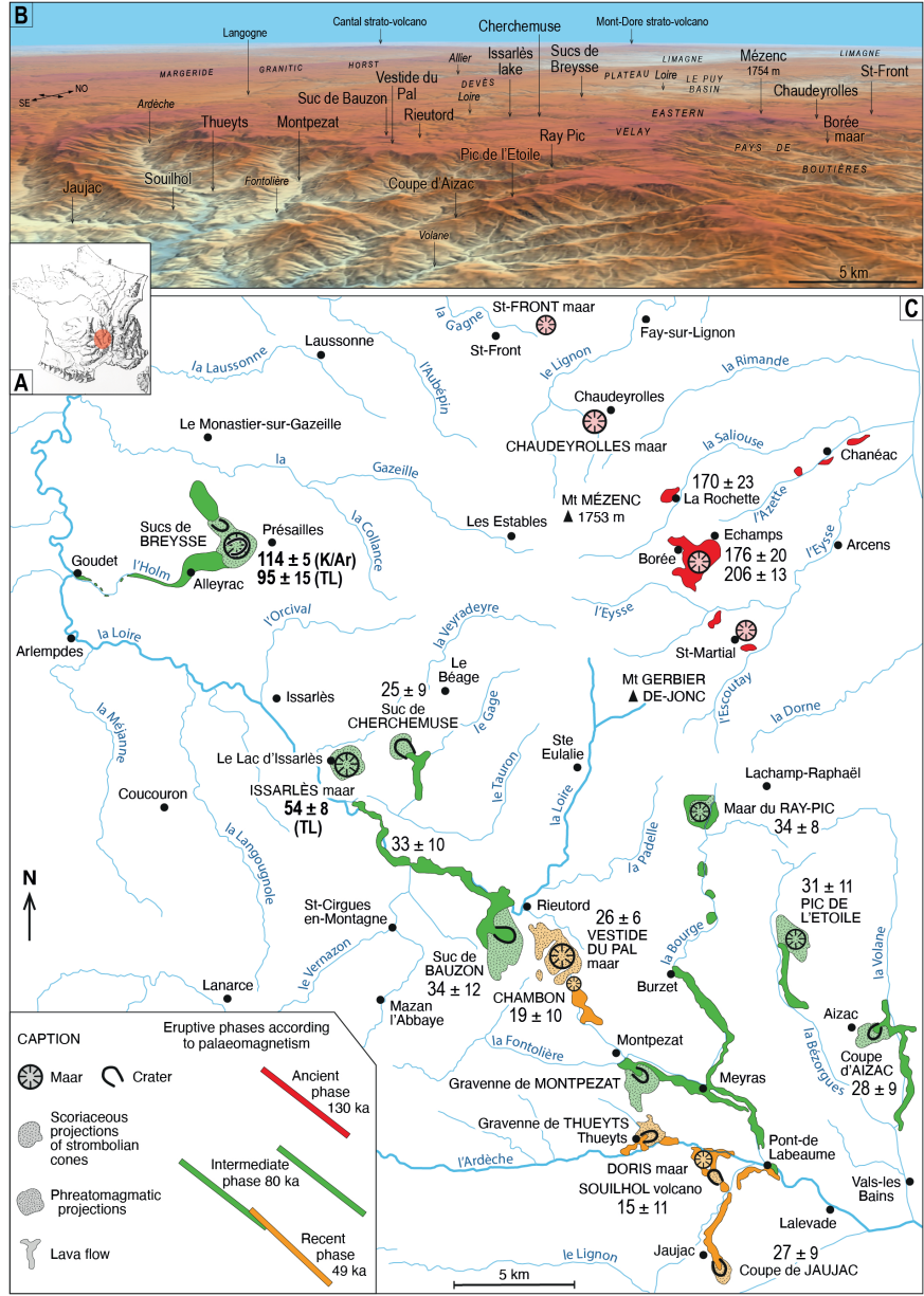
Figure 4. The Bas-Vivarais volcanic province. A) Location in France. B) Position of volcanoes and localities on the orographic 3D view (source: IGN Geoportail). C) Distribution and chrono-typology of the different volcanic features (after Rochette 1993, modified). The ages admitted before 2014, according to palaeomagnetism, TL, and 14C, are marked in red, green and orange (Rochette et al. 1993; Guérin & Gillot 2007; Pastre et al. 1994 and Sanzelle et al. 2000). The black numbers in the map are ka ages produced by 39Ar/40Ar method (Nomade et al. 2014; Sasco 2015; Sasco et al. 2017). The bold black numbers in the map are ka ages produced by the authors (see Defive et al. 2023).
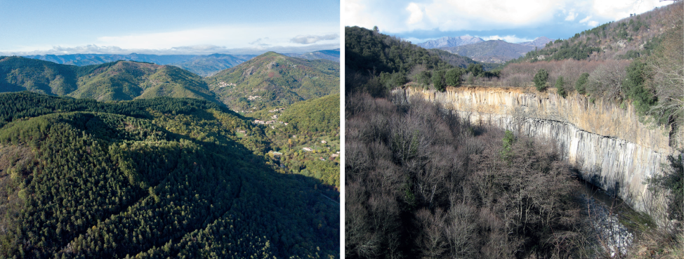
Figure 5. Two aspects of the recent volcanoes of the Bas-Vivarais volcanic province. A) The Aizac volcano (photo S. Tripot, Aubenas-Vals/PNRMA Tourism Office). B) The Jaujac lava flow (photo E. Defive).
Overview of Some Monts d'Ardèche Geosites
Longetrée/Longetraye at Freycenet-la-Cuche (Haute-Loire), An Archaeological Geosite
The "basaltic and prehistoric cliff of Longetraye" is the 55th geosite of the Monts d'Ardèche UNESCO Global Geopark (Fig. 1). It combines the highest prehistoric site in the Massif Central (1210 m) with an exceptional geological situation that allows us to observe the Miocene morphological context, the initial volcanism of the Mézenc plateau, and the impact of Pleistocene climatic variations on the landscape (Fig. 6). It thus makes it possible to question current climate change and the economic future of this mid-mountain area.
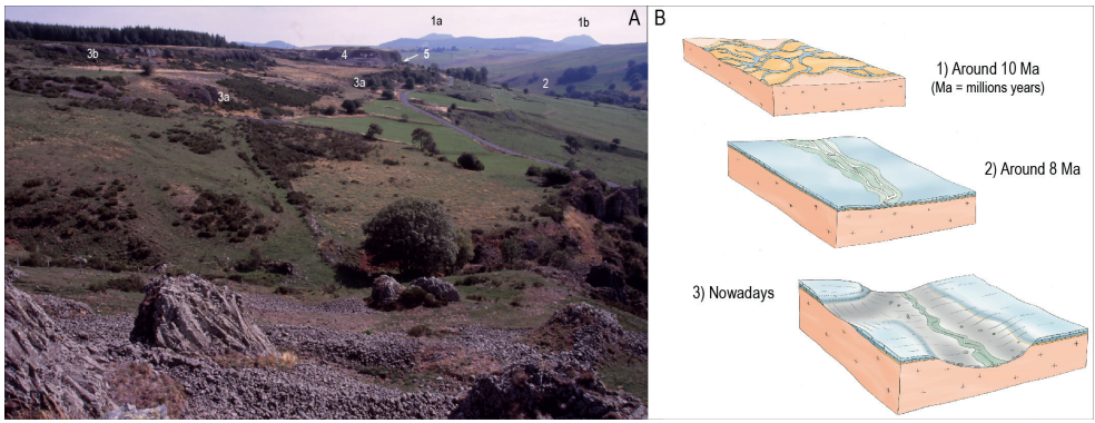
Figure 6. The site of Longetraye. A) View towards the east from the vicinity of Massibrand with 1, in the background, the phonolitic peaks of the heart of the Mézenc massif (a, Taupernas; b, Montfol); 2, the Orcival valley; 3a and 3b, lava flows covering the granitic basement; 4, quarry; 5, location of the "cave" of the archaeological site. B) Stages in the evolution of the relief, with 1, ante-volcanic granitic plateau, crossed by watercourses spreading their alluviums with quartz and cherts pebbles; 2, setting up of the lava flows of the Béage plateau and reorganization of the hydrographic network; 3, down-cutting of the Orcival Valley in the lava flows and then in the basement (photo and CAD E. Defive).
It is located on the south-western edge of the Mézenc massif, in the heart of the Eastern Velay volcanic province, where basaltic to trachy-andesitic lava flows, emitted between 10 and 8 Ma, formed a vast plateau above the granitic basement (Fig. 2). Between 8 and 6 Ma, the latter was pierced by trachytic to phonolitic lavas (domes, dome-flows and lava flows) which form all the visible summits. This ensemble is extended to the south and southeast by plateaus gently sloping towards the northwest (1300 m to 1250 m approximately; Defive 1996 ; Defive et al. 2011). At Longetraye, two basaltic flows with regular columnar jointing and thick entablature are stacked. The upper one, was dated by the Potassium/Argon (K/Ar) method at 8.81 ± 0.13 Ma (Defive et al. 2023; Raynal et al. 2023) and has been quarried since the 1970s. These lavas covered a poorly differentiated topography, in the hollows of which were present clayey-sandy lacustrine deposits, themselves covered by coarse alluviums with cherts and quartz pebbles which were deposited under warm climates in a very wide, shallow, cradle-shaped valley, the axis of which lies slightly further west of the site.
At the time the Longetraye lava flows were emitted, the Orcival Valley did not exist, and we must imagine then a vast plateau on which the watercourses settled and then became entrenched, downcutting the lava flows and the granitic basement. This happened under the hot climatic conditions of the end of the Miocene, then during the finally cooling climates of the Pliocene, none of these conditions were favorable to the development of narrow valleys. This gave birth to the slopes that frame the Orcival Valley today.
The last phases of their evolution took place in the cold atmosphere of the Quaternary glacial times, which lasted several tens of thousand years and were separated by shorter, more temperate interglacials, such as the Holocene in which we live. During the last of these glacial episodes, all the massifs of the western Massif Central were glaciated (Defive et al. 2019; Ancrenaz et al. 2022; Ancrenaz 2023) but most authors consider this sector of the Mézenc massif evolved under periglacial but not glacial conditions, i.e. in very cold and more or less dry environments, marked by the great efficiency of all the erosion processes linked to frost and snow, but without the presence of glaciers. It was in this context that the Longetraye rock shelters were finally hollowed and that the valley-side of the Orcival below evolved, giving rise to the shape that characterizes it today (Defive et al. 2015; Fig. 7). This slope is broken by a succession of flats and scarps linked to the past creep of thick slope formations rich in basaltic boulders resulting from the dismantling of the summit cornice, by gelifraction and gravity. In these cold contexts, the sandy-clay deposits present at the contact between the base and the lava flows have favored creep dynamics. Entire portions of the lava flow's entablature were gradually detached from the cornice and line the slope on which they were dragged after having slowly subsided in the middle of the debris produced by gelifraction.
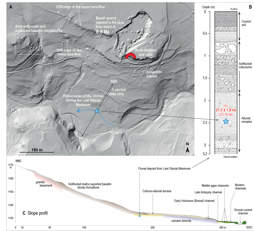
Figure 7. General layout of the Longetraye geosite on the right bank of the Orcival. A) Plan view on LIDAR background (2017). B) Stratigraphy of the deposits at the contact of the foot of the slope with the valley floor. C) Profile of the slope below the archaeological site and chronological milestones (CAD E. Defive).
Forming a cornice above the Orcival valley, the rim of the upper flow is marked by a line of rock shelters developed at the expense of the columnar jointing, under the overhang of the entablature. The formation of shelters at the foot of a basaltic flow with false-prisms entablature is generally explained by the differential resistance to the frost of the different parts of the lava mass, which is responsible for a more rapid retreat of the columnar jointing (Kieffer & Raynal 2001; Raynal & Kieffer 2003). The most important cavity in this line of shelters, Longetraye Cave, seems to have developed at the expense of a voluminous breccia package whose covering by the lava flow locally thwarted the formation of the columnar jointing, the prisms reappearing and then lengthening on either side of this accident. Configurations of the same type, clearly visible on the working faces of the neighboring quarry, give a clear image of the situation before the hollowing out of the cavity.
At the foot of the line of rock shelters and the "cave", in a deposit of more than 2 m, several archaeological levels of the Late Upper Palaeolithic, Mesolithic, Neolithic and Iron ages, were revealed by several excavations. The archaeo-sequence of the Longetraye site attests to a repeated presence at high altitudes since the end of the Ice Age and to the circulation of materials and/or humans within extended spaces, which are essential elements for understanding human activities in the terminal Pleistocene and Holocene in this high-altitude area at the junction of the Mediterranean and Atlantic domains. It is a key complement to the information delivered by the sites in the upper Loire and Allier valleys, Le Puy basin and the Vivarais region.
The severe climatic conditions mentioned by successive excavators from last century have perhaps been mitigated today, but the annual snow cover (Fig. 8) still causes significant percolation in the mass of the archaeological deposit, which is well protected by suitable backfill, and the route adopted for the visit of this part of the geosite does not affect it in any way. The same cannot be said of the Miocene basalt flow, which has been vigorously eaten away over the last five decades by a lithophagous quarry, which nevertheless offers the visitor some remarkable views of its internal architecture. The delicate connection between economics, heritage conservation, and scientific tourism is thus achieved here in relative harmony.
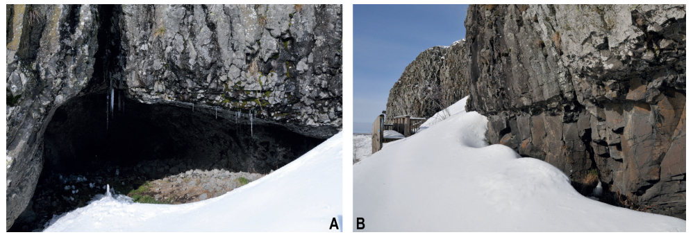
Figure 8. Snow cover on January 16th, 2021 at Longetraye (photos E. Defive). A) At the front of the cave. B) Along the lava flow cliff on the path to the cave.
This geosite has many facets and a virtual extension that goes far beyond the perimeter of its formal presentation with the help of various adapted furnishings (Fig. 9). These allow us to address the geological history of the Vivaro-Vellave plateau, repeated changes in the past climate and its future, digging and shaping of the slopes of the Orcival valley and, finally, the dynamics of human circulation and settlements at altitude since the end of the Ice Age. In this way, hunting and gathering, pastoralism and agriculture provide a rich conservatory from flaked stone to polished stone, ceramics and metals; from the open spaces of prehistory to historical appropriations of all kinds. Therefore we see many entries into the various "eohistorical" registers, suggested by the graphic and textual information brought to our attention on this atypical geosite.
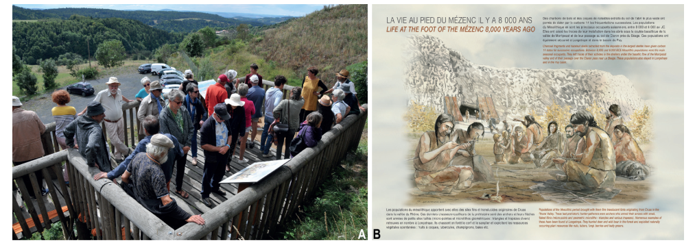
Figure 9. Interpretation on the Longetraye geosite. A) Guided visit; the public in front of the cave (photo E. Defive). B) One of the tables set up in front of the cave (scientific content: J.P. Raynal and E. Defive; drawing P. Legobien).
Borée: An Outstanding Collection of Volcanic Sites!
The commune of Borée is located in the heart of the Hautes Boutières graben, in the Eyrieux basin, a right bank tributary of the Rhône. It occupies a remarkable place within the Monts d'Ardèche UNESCO World Geopark, with six geosites, all related to volcanism, i.e. about 20 % of the volcanic geosites and nearly 10 % of the geosites of the Geopark (Fig. 1). Borée territory also concentrates a quarter of the Geopark sites included in the National Inventory of Geological Heritage.
The geological and geomorphological history can be approached in great temporal depth. The spectrum of landscape forms ranges from the flattened and low-lying topography, punctuated by lacustrine and fluvial deposits covered by the lava flows of the Eastern Velay at the end of the Miocene (10-8 Ma), to the current anthropized landscapes. Local manifestations of recent volcanism of the Bas-Vivarais (here dated between 229,000 and 147,000 years, taking into account the margins of uncertainties), are contemporary with the glacial-interglacial alternations of the Middle and Upper Pleistocene (Fig. 10).
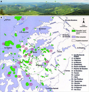
Figure 10. Geology of Borée territory and its surroundings (CAD E. Defive). A) A view towards south-east from Mézenc summit (photo E. Defive) with 1, Gerbier-de-Jonc; 2, Echamps plain and Echamps-Molines maar; 3, Roches de Borée; 4, Suc of Gouleïou; 5, Suc of Chabrières; 6, Suc of Touron; 7, Sara ring dyke; 8, Pradoux ring dyke; 9, Boutières cirque. B) Geological simplified map (after Boivin & Mergoil 2022, modified).
At the western extremity of the commune and on the southern side of Mont Mézenc, the Cirque des Boutières geosite is popular for its striking topographical contrast and the sumptuous scenery offered to the Alpes at the Croix de Boutières, from Mont Blanc to Mont Ventoux. The cirque itself, at the Saliouse headwaters, has been sculpted by millions of years of erosion which has torn open the heart of an ancient polygenic volcano (Fig. 11). The latter appears to be made up of lava flows, scoriaceous projections and hyaloclastic breccias with palagonite which characterize Surtseyan hydromagmatic activity. All are cut by mugearitic dykes and a phonolite intrusion. Here, as at the Saint-Clément geosite (a plateau at the north-eastern limit of the Hautes Boutières where 13 lava flows evolving from basanite to trachyte were superimposed between 10 and 8 Ma) we observe a progressive differentiation of the magma within an intracrustal reservoir (Berger et al. 1976).
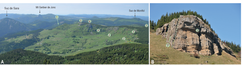
Figure 11. The Cirque des Boutières site. A) Overview with 1, phreatomagmatic deposits at the bottom of the structure on the southern slope; 2, volcanic breccia; 3, hyaloclastic tuffs with palagonite; 4, lava flows; 5, top trachytic lava flow; 6, phonolitic intrusion. B) Detail of the hyaloclastic tuffs (3) intersected by a dyke of mugearite (7) (photos and CAD E. Defive).
The other striking features of the relief, whether you look eastwards from the Croix de Boutières or westwards from the Borée Virgin or the Molines quarry, are the numerous "sucs" (trachytic to phonolitic lavas) which create a rugged topography and give the landscape a monumental character. They correspond to the "pasty" lava flows which, between 8 and 6 Ma, made their way through the Eastern Velay basaltic plateaus previously established (10-8 Ma). In this heart of the massif, which is the richest in Europe in terms of phonolitic occurrences, the commune of Borée concentrates the greatest number of sites. Most of them are lavas that protruded and did not reach the surface (Touron, Chabrières, Gouleïou, Roches de Borée, Rocher des Pradoux, Pialoux, Combeyre). Only the Suc de Sara (Fig. 12), a remarkable annular structure close to that of the Rocher des Pradoux (Fig. 12), seems to have just poked its nose above the basement, while 500 m lower down, the vein, deeply exposed by erosion, presents a micrograined structure typical of a hypovolcanic facies (Mergoil 1968). Similar examples are found in the western part of Eastern Velay, where most of the phonolitic lavas which reached the surface formed the peaks that currently dominate the plateau (extrusion of Mont Gerbier de Jonc; domes of Mont Signon, Suc de Montfol or Bachat; dome-flows of Mont d'Alambre or Rocher Tourte; lava flows of Les Roches, La Lauzière or Les Coux), and the Mézenc which is a composite dome and a geosite of the commune of Borée (Fig. 12). Being the highest point of the plateau (1753 m) and the 4th highest peak in the Massif Central, it straddles the divide between the Atlantic and Mediterranean watersheds. A certain number of remarkable petrographic characteristics come in addition to the interest in the structures and reliefs of these multiple "sucs".
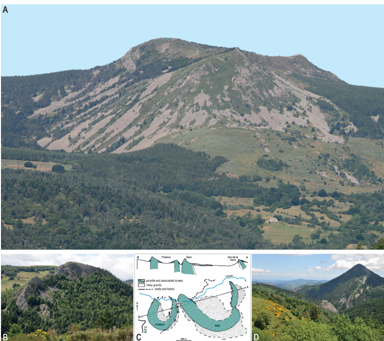
Figure 12. A) The Mont Mézenc complex (two coalescent domes and a dyke) with huge phonolitic screes on its southern and eastern slopes. B) Ring dyke of Pradoux. C) Simplified geological map of Pradoux-Sara ring dyke complex (after Goër & Mergoil 1971, modified) D) Ring dykes of Sara. (CAD and photos E. Defive).
o groups can be distinguished within the Eastern Velay phonolites, according to the order of crystallization of the minerals. The lava from Rocher des Pradoux represents the group of miaskitic phonolites with a normal order of crystallization; the tingaïte from the Suc de Sara represents the group of agpaïtic phonolites with an inverse order of crystallization.
The remarkable Suc de Sara also offers the possibility to observe the contact modalities between the ascending lava and the surrounding basement and the consequences for its texture. Various clues prove that the lava, which usually rises at temperatures around 800– 900°C, was at the limit of consolidation: at the external contact with the granite, the phonolite forms rocky blades linked to the shearing that affected the almost solidified lava during its ascent; these blades are absent in the heart of the vein. In this same edge zone, the arrangement of crystals in the rock, where dark veins of ægyrin appear, also testifies to the shear stress, which is absent in the heart of the vein where the ægyrin crystals are homogeneously distributed (Fig. 13). At the inner edge of the vein, the appearance of the rock shows a more rapid cooling, interpreted as being linked to the maintenance of a void between the very pasty lava and its granitic casing. Finally, at the edges of the vein, large quantities of gases and fluids of varying degrees of heat and aggression must have circulated before, during and after the lava was emplaced, and these have profoundly transformed the surrounding granite.
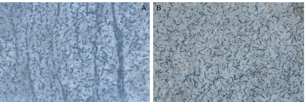
Figure 13. The hypovolcanic microlithic texture with ægirine minerals of the Sara tingaïte (agpaïtic phonolite). A) Dark veins of ægyrin near the edge zone of the ring dyke. B) Aegyrin crystals homogeneously distributed in the heart of the dyke (photos E. Defive).
The Suc de Chabrières, another geosite in the commune of Borée, opens up other petrographic and magmatic questions which make it a unicum in the Eastern Velay volcanic province (Fig. 14). Aged 8.2 ± 0.2 Ma, it presents a good example of "ball phonolite", a classic facies for this type of rock in which spheric figures develop (ocelles or spherulites). Under the effect of erosion, they take on the appearance of large lumps, the famous "balls", which eventually break off, contributing to the degradation of the rock. These structures seem to develop preferentially at the edge of the intrusion in connection with the fluids and gases that circulated there at the time and in the late phases of the setting and solidification of the lava (Machin 2008). They also appear to be associated with fine tubular conduits, perhaps linked to these circulations. More original is the trachytic explosion breccia with ignimbrite facies which is spacially associated with the intrusion but is more recent and without a genetic relationship with it. It can be observed over a thickness of nearly 200 m and within a radius of 1,000 m at the foot of the "suc" and in the neighboring valley of the Saliouse. It is thought to be the result of the sudden emptying of a chamber containing magma infused with carbonatite fluids (Hodges 1991; see also in Ray-Pic chapter infra). An uncharred sequoia trunk was discovered there, testifying to a setting temperature below 200°C during a very violent eruption that must have erased the surrounding plant cover (Naud 1998).
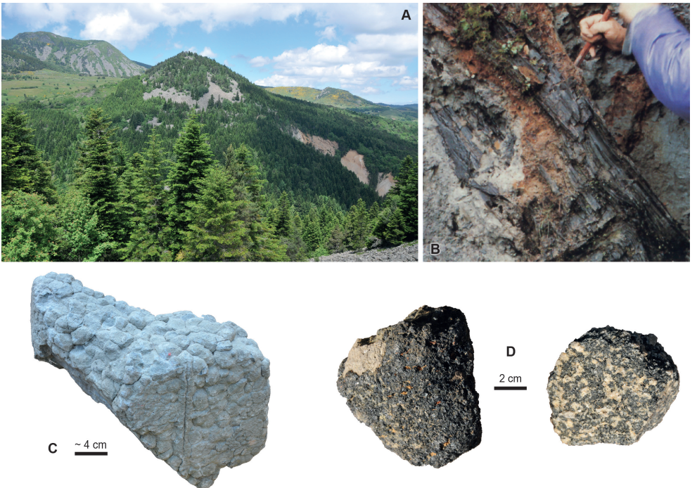
Figure 14. The Suc de Chabrières geosite (and the Mont Mézenc behind on the left). A) The "suc" with its phonolite screes ring, and the natural outcrops in the trachytic breccia down in the right. B) Extraction of a sequoia trunk from the trachytic breccia (photo R. Meucci; Naud 1998). C) Block of "ball phonolite". D) Two cumulates found in the trachytic breccia, which indicate the magmatic room emptying.
The recent volcanism of the Bas-Vivarais is also represented in the commune of Borée by the geosite of the Echamps-Molines maar (Fig. 15). Its age is now estimated between 219,000 and 156,000 yr (Nomade et al. 2014; Sasco 2015; Sasco et al. 2017). At that time, the valleys were already dug almost to their present level. The volcano was established on a ridge bearing only remnants of the old Eastern Velay volcanism (10-6.5 Ma), between the Eysse and Saliouse valleys and at the head of the small Azette valley. The activity began with a phreatomagmatic phase, forming the deposits visible in the Molines quarry where all the typical sedimentological features of this eruptive dynamism can be observed. A gradual transition to a strombolian phase is recorded, during which several cones were built around the maar. A basaltic lava, rich in xenocrysts and xenoliths from the basement and the mantle (Berger & Prinzhofer 1977), was emitted and filled up the crater forming the Échamps plain, an unusual topographical plane perched above deep valleys. From there, the basalt overflowed at two points and then followed the Eysse Valley as far as Saint-Martial and the Azette Valley as far as the Pont des Lièvres, 8 km downstream at the confluence with the Saliouse valley. In both valleys, the arrival of the lava flow was preceded by syneruptive lahars reworking the freshly emitted phreatomagmatic products, and covering the coarse alluvium of the talwegs. The lava flows preserved them from total erosion. These spectacular outcrops are regularly integrated into scientific excursions and training courses organized by French and foreign universities and leading scientific graduate schools.
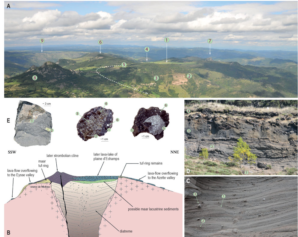
Figure 15. A geosite linked to the Bas-Vivarais volcanism: the maar of Échamps-Molines. A) View on the geosite from the top of Sara "suc" with 1, the Échamps plain perched above deep valleys; 2, the maar tuff ring in the Molines quarry; 3, Molines spring position above the hamlet; 4, overflow lava flow point position in the Azette valley; 5, way of the lava flow overflow in the Eysse valley; 6, Pialoux phonolite; 7, Soutron phonolite; 8, Roches de Borée phonolitic "sucs"; 9, Saint-Clément village and volcanic plateau (Eastern Velay volcanic province). B) Synthetic profile of the Échamps-Molines maar structure (after Mergoil & Boivin 1993, modified). C) Typical sedimentological features on the phreatomagmatic deposit lower part with 1, typical base surges; 2, anti-dunes; 3, bomb sag. D) Upper part of the Molines quarry with the transition from phreatomagmatic to strombolian deposits with 1, phreatomagmatic deposits with external dip; 2, channeled phreatomagmatic deposits with internal dip; 3, accretionary lapilli; 4, basaltic sill at the bottom of strombolian adventive volcano. E) Facies of lava and bombs of the eruption, from left to right: Échamps-Azette lava flow sample, bomb with enclave of peridotite and bomb with enclave of basement at Molines quarry. For the two bombs, the numbers correspond to 1, juvenile magma; 2, peridotite enclave; 3, olivine crystals; 4, pyroxene crystals; 5, reheated basement enclave (buchite); 6, basement xenoliths in the basalt (photos E. Defive).
The rich volcanic heritage of the commune of Borée is expressed first and foremost through its relief. The monumental character of the landscape, which has already been highlighted, is of course due to the geological structures created by internal geodynamics, but also to the erosion which, over the last 8 Ma, has progressively loosened these structures as the valleys were excavated and favored the dismantling of the rocky masses by gelifraction during the cold periods of the Quaternary (Figs. 10, 16). This dismantling was particularly active because the fluidal structure of the phonolites renders them particularly sensitive to frost action at all scales. The imposing scree slabs thus produced which surround the "sucs" make them even more visible in the landscape. The periglacial context which ruled these dynamics did not prevent the development of large firms or small glaciers in the most favorable cirques that border the western edge of the Hautes Boutières. This was the case at the Cirque des Boutières already mentioned and at the north-eastern extremity of the Mézenc, at the Cirque de Médille and in the Antraygues valley (a tributary of the Saliouse), where a black glacier that was not very active built a frontal moraine, still visible in the landscape (Valadas 1984; Veyret 1980, 1981; Neboit & Veyret 1976; Defive et al. 2019).
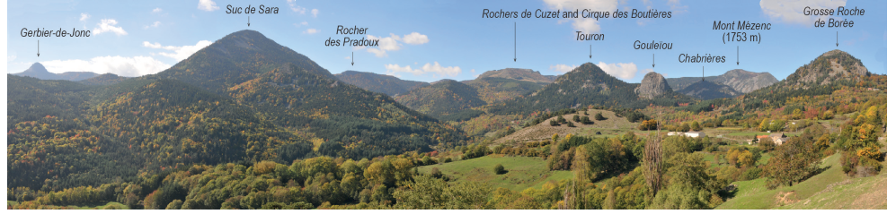
Figure 16. Monumental scenery of the Hautes Boutières looking to the west from Molines quarry (photo E. Defive).
The variety of environments and landscapes that currently characterize the commune of Borée is the result of this long history and of the different ways in which peoples have developed their habitations (Fig. 17). Numerous signs of the complex web of interactions between societies and environments which, for thousands of years, have shaped the environments and landscapes and include a variety of soils, parcels of land, specificities of the vernacular architecture using the petrographic spectrum of local rocks, the Échamps dolmen made of large slabs of phonolite, the management of water supplied in abundance by the Molines spring draining the imposing natural reservoir of the Échamps maar diatrem, and finally the development of the paths to the summit of the Mézenc to channel the flow of tourists to reduce the degradation of the plant cover and sensitive soils. All these fully justify the advent of geo-patrimonial values.
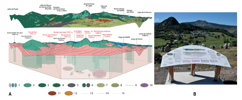
Figure 17. Interpretation of Borée scenery. A) Table extract (CAD E. Defive) with legend: 1, Crests, ledges and steep slopes where the rock (granite / flows / trachytes and phonolites) outcrops; 2, Screes formed a few thousand years ago during a cold period when frost action favored the fragmentation of rocks; 3, Large spruce plantations set up by the Government (end of the 19th century and 1950s); 4, "Postage stamp" afforestation on private plots of land that have been abandoned (1950s); 5, Beech forests naturally adapted to mountain conditions; 6, Mixed woodland (spruce and Scots pine / beech and coniferous) linked to the spontaneous spreading of trees; 7, Meadows (grass is mown for hay) and pastures (unmown plots); 8, Wasteland on abandoned plots of land because they are too poor or difficult to work; 9, Hedgerows useful to the traditional rural community (firewood, supplementary ash fodder, small crafts) and guarantors of biodiversity (refuges for fauna); 10, Church and cemetery: traditional gathering places of the village community; 11, Old buildings, made of local stone. At the peak of its population in the 19th century, Borée had more than 2000 inhabitants. Many buildings are now abandoned, sometimes saved from ruin by their conversion into second homes or places of social and cultural life; 12, Recent buildings (breeze blocks, tiles, plastering, hedges surrounding the property); 13, Low walls linked to the spalling of plots and the development of terraced slopes. They represent a constraint for modern mechanized agriculture; 14, The roads, narrow and winding, oblige one to calculate in travel time rather than in km; 15, Only a small number of the traditional network of paths through which humans, animals and goods used to circulate are still maintained. Tourism sometimes favors their reopening. B) the on-site table (photo E. Defive).
Highlighting Magmatic and Effusive Processes at the Ray-Pic Geosite
The Ray-Pic is one of the most visited volcanic geosites in the Monts d'Ardèche UNESCO Global Geopark (around 35,000 visitors per year according to the counter installed at the site, but with significant inter-annual variability). It is located at Péreyres in Ardèche, less than 2 km as the crow flies southwest of Lachamp-Raphaël village, at the headwaters of the Bourges (Figs. 1, 4). Here, at the transition between the high valleys and the first gorges down-cut nearly 400 m below the summit planes, the valley had already been dug to its present level 34,000 years ago (34 ± 8 ka by 39Ar/40Ar in Nomade et al. 2014; Sasco 2015; Sasco et al. 2017).
Linked to the volcanism of the Bas-Vivarais, better known to the public as the "Ardèche Young Volcanoes", this volcano was mentioned in the 18th century by the first scientific visitors who explored this region and recognized the volcanic nature of peculiar edifices and associated rocks (Faujas de Saint-Fond 1778). Two phases of activity succeeded one another during the opening of this crater, as for many other volcanoes in the Bas-Vivarais. The activity began with a violent phreatomagmatic phase, which resulted in typical bedded deposits more or less loaded with pebbles and blocks, essentially from crystalline rocks. Then the eruptive dynamism changed quite abruptly to a strombolian phase (Fig. 18). In addition to the scoriaceous accumulations, a lava lake formed, and a lava flow poured into the Bourges valley. The subsequent re-entrenchment by the river allows the observation of the intra-crateric contact between the basalt and the surrounding basement and of the spectacular prismatic sheaf-like structure of the lava mass, about 50 m thick and cascaded by the Bourges (Fig. 19).
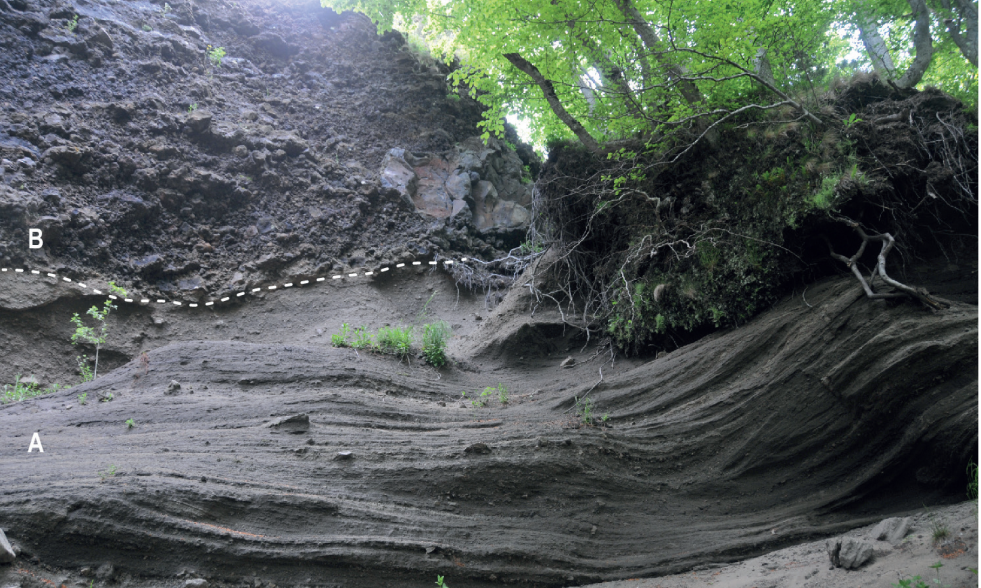
Figure 18. Close view of the Ray-Pic volcano deposits. Section illustrating the transition from phreatomagmatic (A) to strombolian (B) activity at the eastern extremity of the crater (photos E. Defive).
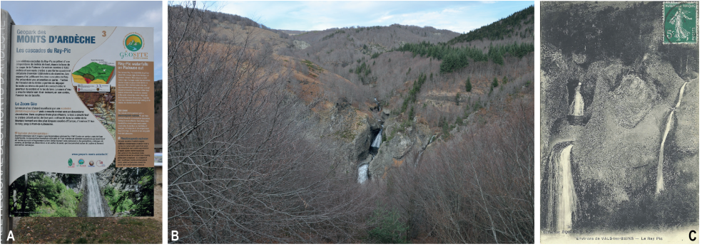
Figure 19. The Ray-Pic geosite. A) On-site Geopark welcom totem (photo E. Defive). B) The Bourges waters pouring out through the crater basaltic lava lake (photo E. Defive). C) A closer view of the waterfalls from an ancient postcard (1911).
The Ray-Pic flow cannot be separated from the geosite sensu stricto. The 21 km it covered in the Bourges Valley and then in the Fontolière Valley as far as Pont-de-Labeaume, at the confluence with the Ardèche, make it one of the longest flows in the Massif Central. This testifies to both the huge volume of lava emitted and its great fluidity, to the point of having left no traces of its passage between the crater and Péreyres (Berger 2007). Further on, it is preserved in places perched on the left or on the right bank or still occupying the Bourges talweg and causing the development of beautiful waterfalls, as at Chastagnas bridge between Péreyres and Burzet. It thus appears that in a certain number of places, the work of re-incision after the outpouring of the flow was not successful in retrieving the talweg of 34,000 years ago. Because of its length, the Ray-Pic lava flow has also allowed, since the pioneer researches, the establishment of a relative chronology concerning several of the Bas-Vivarais volcanoes whose lava flows met at various confluence points. At the Bourges-Fontolière confluence, the Ray-Pic lava flow is thus covered by the Gravenne de Montpezat lava flow. The absence of paleosol and erosion marks at the contact between the two lava flows suggests that the Gravenne de Montpezat erupted shortly after the Ray-Pic. Further downstream, at the confluence between Fontolière and Ardèche, the Souilhol flow overlaps the extremity of the Ray-Pic lava flow, there with clear evidence of a time lag marked by an intermediate phase of erosion, successive fluvial deposition and then pedogenesis (Berger 2007, p. 105).
Along with the other volcanoes of the Bas-Vivarais, the Ray-Pic geosite finally allows us to address questions of magmatology, which are the subject of the most recent works on this exceptional volcanic province (Buso 2019; Schiavi et al. 2020; Buso et al. 2022; Buso 2023). These works aim to answer two fundamental questions: where and how did the magmas form? How long did it take for magma to reach the surface? To answer the first question, we studied the tiny glassy inclusions contained in the olivine crystals of volcanic products (Fig. 20). These inclusions, often less than 50 µm in size, are small droplets of magma that were trapped during the growth of the olivine crystals and that recorded the early stages of the host magma's history. Their systematic characterization by different chemical analysis techniques and high pressure-high temperature experiments has allowed the composition and formation conditions of the magmas at depth to be specified. The Bas-Vivarais magmas have basanitic compositions and were formed at a depth of more than 70-80 km and at temperatures close to 1300 °C. Their most remarkable feature is a very high carbon dioxide content, with values up to 4-5 wt % CO2, which is a world record for this type of volcanism (Buso et al. 2022; Buso 2023). It is probable the percolation of carbonatitic fluids of deep origin in the source mantle of the Bas-Vivarais magmas that explains their CO2 richness.
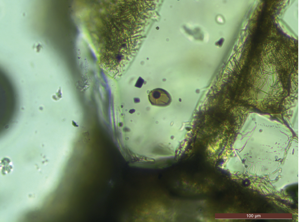
Figure 20. Optical microphotography showing a glassy inclusion (brown) containing a dark CO2 bubble in the core of an olivine phenocryst in a basanite from the Bas-Vivarais volcanic province. The olivine phenocryst is embedded in a volcanic matrix (a mixture of microlites and interstitial glass) visible in the upper left and lower right corners (from Buso 2023).

Moreover, it is in the strombolian projections of Ray-Pic, whose lava is reputed to be rich in mantle enclaves, that we have found the largest peridotite enclave known in the Massif Central (approximately 50 x 32 x 26 cm, i.e. an estimated mass of 120 kg; Fig. 21). How could such a large enclave, denser than the containing magma, reach the surface? Calculations made considering the characteristics of the Bas-Vivarais lavas (composition, dissolved water content, viscosity) give a fall velocity of the enclave in the magma of more than 50 km/h (for a magma temperature of 1275°C), and therefore an even higher magma ascent velocity for the enclave to reach the surface. Apart from this huge enclave, peridotite enclaves rarely exceed 20 kg and correspond to an average ascent velocity of the Bas-Vivarais lavas of around 10 km/h (Buso 2019). These high ascent rates are presumably related to the exceptional content of dissolved CO2 in the magmas. This information takes on another dimension in terms of volcanic risk management. It turns out that such an ascent velocity, with magma source regions located at a little more than 70-80 km depth, would result in their arrival at the surface in less than ten hours, leaving very little time for the detection of possible precursor signals of an eruption.
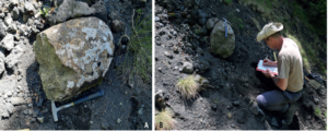
Figure 21. Photograph of what is to our knowledge the largest peridotite found in the French Massif Central (photos: A) D. Laporte; B) E. Defive).
The Ray-Pic geosite is, therefore, a very good example of the links that can be established and emphasized between scientific values, heritage values and societal utility. Its high level of use requires adapted facilities and management that also considers the preservation of the environment and the risks inherent in rocky rugged topographies and torrential rivers. This raises the delicate question of how to reconcile the preservation of the "natural" character of the sites, freedom of movement and controlled (managed, channeled) use for the benefit of knowledge, environmental education, and the local economy (tourism).
Geotourism, Education And Conservation in Monts d'Ardèche Geopark
When the Monts d'Ardèche Regional Nature Park embarked on the process of obtaining the UNESCO Global Geopark label in 2012-2013, it was primarily for tourism and heritage reasons. Sustainable tourism is of course a major pillar of the dynamics of a Geopark. Discovery of the landscape and geological heritage cannot be relocated because it is based on the territory's assets. This logic led to the territory's involvement in labeling the Pont d'Arc ornate cave, known as the Chauvet Cave, as a World Heritage site, and above all to achieving the construction of the world's largest replica of such a cave. The discovery offer was certainly strengthened but the limited access for visitors did not make obvious the immediate economic benefits.
Without forgetting the scientific and educational dimensions, the priority for the 2010s was to increase the number of visitors to the area, in particular by increasing the range of activities linked to volcanic heritage, which represents the majority of the 61 Geosites in the Monts d'Ardèche UNESCO Global Geopark. To achieve this goal, a strategy was implemented based on a four-year cycle of validation periods for 2015-2018 then 2019-2022 (the 2023-2026 strategy is currently being drafted) (Klee 2019). The third axis of this strategy is entirely devoted to the promotion of geoheritage and the strengthening of the tourist offer. It has been conceived as a mix of:
- Scientific mediation by humans (specialists and guides), delivering of first information by the prescriptors (tourist offices, museums, and hotels).
- Digital tools: data online, creating a hiking application with heritage information (P.O.I.) and creating the first prototypes of virtual and augmented realities while waiting for them to become a reality.
- Paper: publication of brochures, maps and a walking
- Physical support: through the development of sites and paths, installation of interpretation displays, and new museography.
The most visible aspect for the public - but the greatest financial impact - is probably the creation of signage and interpretation equipment for the geosites. During the past eight years, more than 120 totems have been installed at more than 60 sites to welcome visitors and explain the geological heritage (Fig. 19). They allow all visitors to have an initial presentation and explanation of the site they are about to discover. During this time, 25 geosites and visitior areas were equipped with interpretation tools to really immerse the visitor in the discovery of the site and to give meaning to the visit. In most cases, an original approach was chosen through a discovery scenario linking the geological heritage, the local buildings, the flora and fauna and the agricultural activities. The example of the Geosite of the prehistoric cliff of Longetraye is truly representative of the type of development that has been carried out on the sites (Fig. 9).
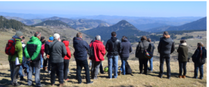
Figure 22. Training of the tourism stakeholders: looking towards the Boutières scenery from the Croix de Boutières Pass (photo N. Klee).
Human intervention and discovery panels on the geosites (Fig. 9, 17) are complementary approaches and address different audiences. Over eight years, more than 260 tourism professionals have been trained in the basics of the geology of the Monts d'Ardèche (Fig. 22). The idea is obviously not to turn them into geologists, but to give them the key elements to better understand geological history and to help them to be better advisers about sites and visitor activities.
The other central point of the territorial dynamics is the annual animation program (Fig. 23). Since its launch in 2015, the 93 events organized or supported by Geopark have welcomed 4611 participants, a demonstration of the public's undeniable curiosity, if not for geology, at least for the discovery of landscape heritage in the broadest sense. Finally, in terms of communication, many efforts have been made to make the Geopark concept, on the one hand, and the geological history and geosites, on the other, as intelligible as possible for the inhabitants and visitors.
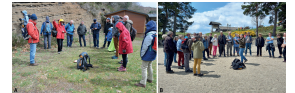
Figure 23. Geological rendez-vous at Issarlès lake. A) 7th of May 2022 (photo P. Bohle). B) 1st of April 2023 (photo E. Defive).
The geosite map, published every year in 20,000 copies, is the basic document that makes it easy to locate the places of interest. In addition, the booklet "Everything you need to know about the Monts d'Ardèche Geopark" provides a first level of reading with a quick presentation on the geological history of the region, and an in-depth look at two major subjects: volcanism and ichnology in the Monts d'Ardèche. The lithoscope, which is more educational, allows the reader to identify the rocks of the region and their use in buildings. The latest edition, the guide of walks and hikes uses these to bring a better understanding of the heritage encountered. Already reissued twice, it also witnesses the public's interest in discovering the area, through geology in the broad sense and volcanism as an essential component.
However, since the COVID-19 pandemic, tourist activity in the Geopark territory has changed. In 2022, Geopark welcomed 19.9 million excursionists (ADT/PNRMA/FVT 2022 data), an increase of 59 % compared to 2019, the reference year before the pandemic. There was a peak on the 16th of July 2022 with 231,000 excursionists present in the area, whereas the 2019 peak was on 17th of August with 101,000 visitors. Visitor numbers exploded after the pandemic for many reasons that are now well documented (need to get away from it all, to reconnect with nature, etc.). Beyond the visiting activities, the number of overnight stays also rose sharply: + 9 % compared to 2019. On 13th August 2022, 85,175 people who do not live in the area all year round slept in the Monts d'Ardèche, which is much more than the number of permanent residents. The counters set up on many of the territory's volcanoes, at the Ray-Pic waterfall, at Mont Signon, at Mont Gerbier de Jonc, also showed an exponential increase in the number of visitors to the territory and to these volcanoes, the main places for excursions and walks. This significant increase in visitor numbers has had a number of impacts on the geosites: in the volcanic areas, erosion has been greatly accelerated in recent years, causing problems for the flora and landscape. The quality of the visitor experience has also been affected, with fewer positive feelings linked to parking difficulties, a feeling of saturation and less immersion in the landscape.
These new data and this new context requires a change of the objectives of the tourist component of the Geopark label: it is no longer a question of welcoming more but better, and above all of offering discoveries and providing knowledge to the inhabitants. The territory's volcanic heritage remains relatively unknown. Above all, knowledge of the "volcanic dimension" of the area needs to be strengthened. All the best-known sites in the area are volcanic ones: Mont Gerbier de Jonc, Mont Mézenc, the Ray-Pic waterfall, the village of Antraigues and the Devil's Bridge at Thueyts. The priority work of the post-pandemic years is, therefore, the presentation of the volcanic heritage of the Ardèche, which remains difficult to read and understand for most of the inhabitants. A particular focus is therefore placed on educational and pedagogical actions aimed at the inhabitants. The new communication campaign about the "Ardèche Young Volcanoes", for example, carried out by the Monts d'Ardèche Geopark and three tourist offices, is aimed primarily at residents of the region or secondary residents, and in particular families, through the prism of walks and familial games (Fig. 24).
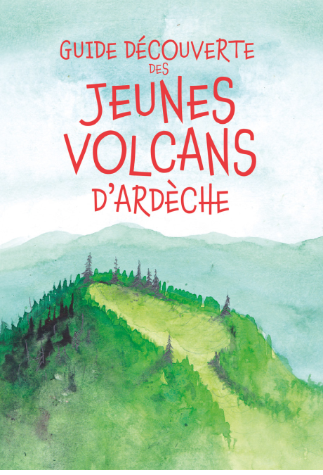
Figure 24. Discovery guide of the "Ardèche Young Volcanoes" (@PNRMA).
Because of the occasional over-visiting suffered by a number of the volcanic sites, the subject of conservation, which was not very present in the previous years of the label (except for the fossil sites), is now at the heart of the discussion about site facilities and communication. The marketing strategy now aims both to deconcentrate visitor numbers on the major volcanic sites (Gerbier, Mézenc) and to preserve the lesser-known ones (Sara, Cinq Sucs). On the old volcanoes as well as on the more recent ones, the challenge of maintaining visitor numbers on the marked trails is a priority, both for reasons of erosion, particularly on the strombolian volcanoes, and for landscape reasons and to preserve the biodiversity linked to the volcanic rocks. On Mont Mézenc, a very substantial renaturation and erosion control operation has committed the Geopark to an intensive two years’ work (Fig. 25). Glory’s price.
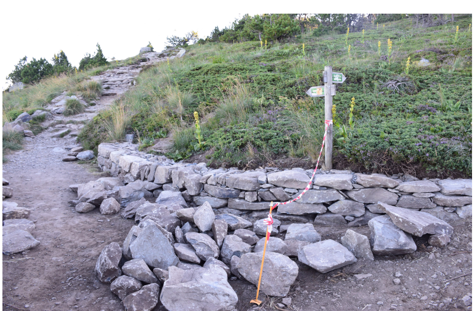
Figure 25. Restoration work on the paths to channel visitors to the Mont Mézenc volcanic geosite (photo N. Klee).
Acknowledgments. Roxane Buso thanks the Région Auvergne-Rhône-Alpes for funding her doctoral thesis (project VolcAURA; Pack Ambition Recherche 2018).