 10.57647/j.gcr.2025.0802.11
Collaborative Cartography as a Tool for Inventory of Waterfalls in Municipalities in Southern Brazil
- Victória Dejan Paganotto*
 1
1 - Adriano Luís Heck Simon2
- Postgraduate Program in Geography, Department of Geosciences, Federal University of Santa Maria, Santa Maria, Rio Grande do Sul, Brazil
- Department of Geography and Graduate Program in Geography, Federal University of Pelotas, Pelotas, Brazil

Received: 2025-06-26
Revised: 2025-09-06
Accepted: 2025-10-07
Published Online: 2025-11-04
Copyright (c) -1 Victória Dejan Paganotto, Adriano Luís Heck Simon (Author)

This work is licensed under a Creative Commons Attribution 4.0 International License.
How to Cite


PDF views: 2


Abstract
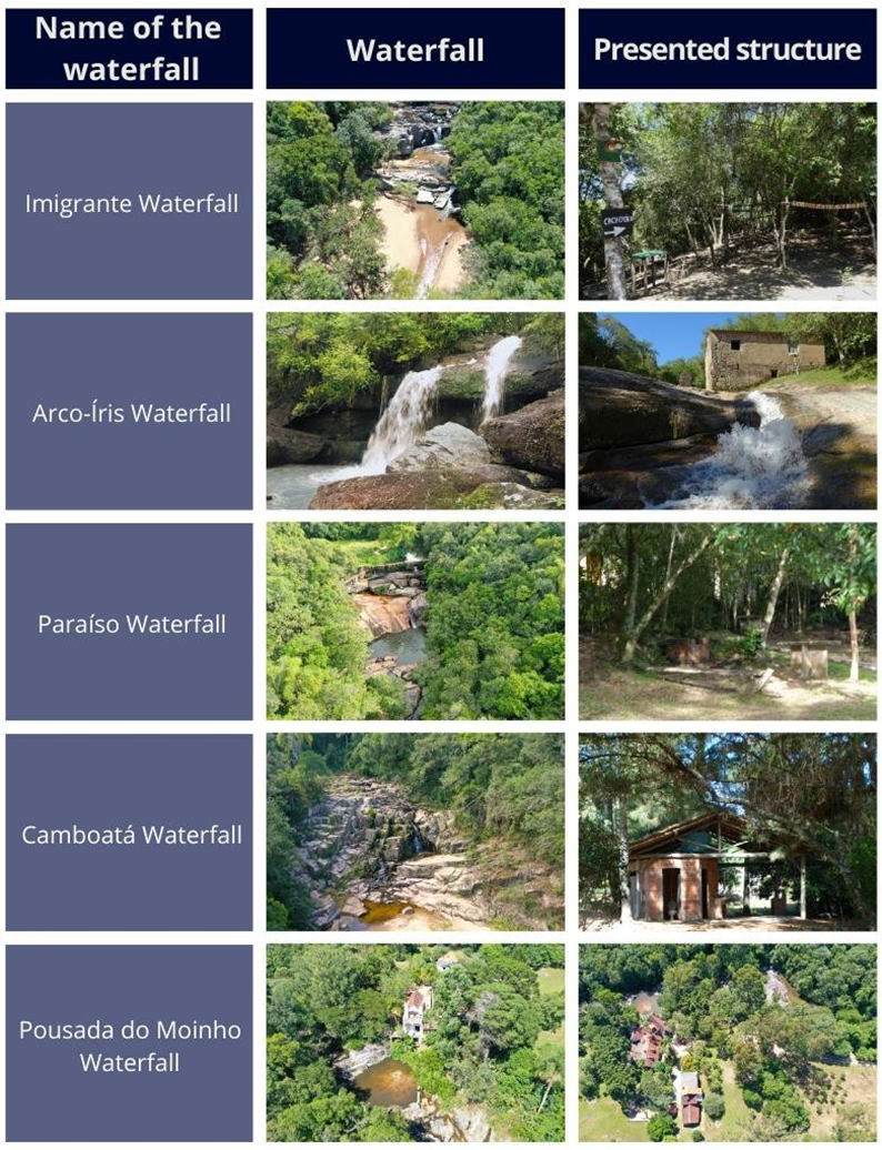
We investigate collaborative cartography as a tool for inventorying waterfalls in the municipalities of Pelotas and Arroio do Padre in southern Brazil. We aim to identify and catalog waterfalls through community participation to support the development of geotourism itineraries and promote the dissemination and environmental interpretation of these geodiversity elements. We employed a two-phase approach through online questionnaires distributed through social media platforms during the COVID-19 pandemic. The first phase (December 2020–March 2021) involved 70 collaborators who identified 17 waterfalls, while the second phase (September–October 2021) engaged 36 additional participants who contributed three new waterfall identifications. The survey instrument, titled "Cachoeiras Costa Doce Form," collected data on waterfall names, locations, and optional photographic documentation. Field validation was conducted in February 2022 using GPS technology and aerial imagery to verify collaborative mapping results and assess waterfall characteristics. Respondents identified 18 waterfalls, with four receiving the highest recognition: Imigrante (25 mentions), Arco-Íris (18 mentions), Paraíso (14 mentions), and Camboatá (14 mentions). Of the five criteria, eight waterfalls demonstrated high accessibility values, seven exhibited significant cultural connections, and eleven maintained excellent environmental preservation status. The study demonstrates that collaborative cartography effectively leverages local community knowledge to identify geoheritage elements, particularly in areas with geological-geomorphological significance. However, limitations include potential selection bias due to digital divide constraints affecting rural populations with limited internet access. The methodology has potential for international replication and contributes to sustainable geotourism development while supporting geoconservation initiatives through community engagement and scientific assessment integration.
Keywords
- Geodiversity,
- Geoheritage,
- Geotourism,
- Volunteered Geographic Information,
- Collaborative Cartography
References
- Almeida MG (2018). Observing and understanding the rural place: Methodological trails. In Vargas MAM, & Santos DL (Eds.). Times and spaces of qualitative research (pp. 45–70). Criação Publisher.
- Athaydes TVS, Stevanato M, Donato L, Parolin M (2018). The use of cartography and collaborative mapping in the analysis of urban problems. Revista de Geografia, Meio Ambiente e Ensino. 8(3):215–224.
- Barbosa MCFA, Remoaldo PCAC, Vieira AAB (2016). Proposal of a WEBSIG for the development of tourist activity in the municipality of Lousada. Acadêmico Mundo Multidisciplinar. (6):1–32. https://www.academicomundo.com/revista-digital/edi%C3%A7%C3%B5es/anteriores/ano-iv-n%C2%BA-6-dezembro-de-2016.
- Bento LCM, Rodrigues SC (2010). Geotourism and geomorphosites: Reflecting on the tourism potential of waterfalls – A case study of the municipality of Indianópolis/MG. Revista Geográfica Acadêmica. 4(2):96–104.
- Brilha J (2005). Património geológico e geoconservação: A conservação da natureza na sua vertente geológica. Palimage Editores.
- Brilha J (2016). Inventory and quantitative assessment of geosites and geodiversity sites: A review. Geoheritage. (8):119–134.
- Cachoeiras Costa Doce (2021, August 27). Cachoeiras Costa Doce [Instagram page]. https://www.instagram.com/cachoeirascostadoce/
- Canva (2024). Canva Design Platform. https://www.canva.com/design/DAEWQD7sbB4/Ac1adZdT2VLrPYWeFPzv5w/edit
- Cardoso JC (2017). Jovens grafando relações entre idosos e cidade pela cartografia colaborativa digital [Master’s dissertation, Federal University of Rio Grande do Sul].
- Cardoso KS (2021). A Escassez Hídrica em Arroio do Padre – RS: da compreensão da problemática às estratégias de enfrentamento [Master’s dissertation, Federal University of Pelotas].
- Coratza P, Bollati IM, Panizza V, Brandolini P, Castaldini D, Cucchi F, ... Trocciola A (2021). Advances in geoheritage mapping: Application to iconic geomorphological examples from the Italian landscape. Sustainability. 13(20):11538. https://doi.org/10.3390/su132011538
- Costa BP (2016). Geography and everyday life: Reflections on research theory and practice. In Heidrich AL, & Pires CLZ (Eds.), Approaches and practices of qualitative research in geography and knowledge about space and culture (pp. 129–149). Gráfica da UFRGS.
- Cruz UB (2012). Colonial region: Gittiari family – Temple of the Waters. Federal University of Pelotas. https://pelotas.ufpel.edu.br/familiagottinari.html
- Cunha NG, Silveira RC, Severo CRS (2006). Solos e terras do planalto Sul-Rio-Grandense e planícies costeiras. Embrapa Clima Temperado.
- Dutra DS (2016). Geomorphological mapping of the area of influence of the South Rio Grande Shield in the municipality of Pelotas/RS [Master’s dissertation, Federal University of Pelotas].
- Edney M (2016). Theory and history of cartography. Espaço e Cultura (UFRJ). (39):209–220.
- EuroGeoSurveys (2024). Geoheritage expert group. https://eurogeosurveys.org/research/our-experts/geoheritage/
- Federal University of Pelotas – UFPel (2025).Pelotas Climate - Monthly Climatological Normals for the Period 1971/2000, https://wp.ufpel.edu.br/agrometeorologia/informacoes/clima-de-pelotas/. Retrieved September 04 2025).
- Geoheritage Sites of the Nation | U.S. Geological Survey (2025). https://www.usgs.gov/centers/geology-energy-and-minerals-science-center/science/geoheritage-sites-nation
- Goodchild MF (2007). Citizens as sensors: The world of volunteered geography. GeoJournal. 69(4):211–221. julhoSetembro
- Gray M (2004). Geodiversity: Valuing and conserving abiotic nature. John Wiley & Sons.
- Harley JB (1989). Deconstructing the map. Cartographica: The International Journal for Geographic Information and Geovisualization. 26(2):1–20.
- Gupta V, Anand S, Wei D, Wang G, Rajesh S (2024). Exploring applied sustainable strategies through geoheritage and geotourism: A systematic literature review. International Journal of Geoheritage and Parks. 12(4):660–677. https://doi.org/10.1016/j.ijgeop.2024.11.009
- Haklay M (2013). Citizen Science and Volunteered Geographic Information: overview and typology of participation. In Sui, DZ, Elwood S, Goodchild MF (Eds.), Crowdsourcing Geographic Knowledge (pp. 105–122). Springer. https://doi.org/10.1007/978-94-007-4587-2_7
- Hasenack H, Weber E (Eds.). (2010). Continuous vector cartographic base of Rio Grande do Sul - scale 1:50.000 (Geoprocessing Series No. 3) [DVD-ROM]. UFRGS Ecology Center.
- Henriques MH, Brilha J (2017). UNESCO Global Geoparks: a strategy towards global understanding and sustainability. Episodes. 40(4):349–355. https://doi.org/10.18814/epiiugs/2017/v40i4/017036
- Rio Grande do Sul Rice Institute – IRGA. (2020, July 01). Report on the drought in the 2019/2020 harvest. Porto Alegre: IRGA. https://irga.rs.gov.br/relatorio-sobre-a-estiagem-da-safra-2019-2020. Retrieved September 03 2025.
- Laux JH, Takehara L, Stropper JL, Provenzano CAS, & Scherer OLB (2019). Map of tectonic associations and mineral resources – Pelotas batholith/Tijucas terrain [Map, scale 1:500,000]. Geological Survey of Brazil.
- Luerce TD (2015). Geotourism in the Rolante/RS river basin: A study of the waterfalls [Master’s dissertation, Federal University of Rio Grande do Sul].
- Martins Junior OG (2018). Behavioral archetypes in collaborative cartography projects [Master’s thesis, Military Engineering Institute].
- Martins Junior OG, Silva LFCF (2018). Proposed hierarchy for collaborative cartography concepts. Anuário do Instituto de Geociências. 41(3):281–291.
- Moraes L, Carvalho C, Rendeiro ML, Gil T (2021). Eliminating white spots: A dismantling of Curt Nimuendajú’s indigenist cartography. História da Historiografia. 14(37):17–61.
- National Institute of Meteorology – INMET. (2025). Meteorological data from the Capão do Leão Station (Pelotas) - Code A887. https://portal.inmet.gov.br/. Retrieved September 02 2025
- Oliveira CKR, Salgado AAR, Lopes FWA (2017). Proposal for classifying the relevance of waterfalls to support the conservation of natural heritage. Revista Brasileira de Geomorfologia. 18(3):465–481.
- Paganotto VD (2022). The waterfalls as geopatrimony of the municipalities of Pelotas and Arroio do Padre: Contributions to geotourism on the Costa Doce of Rio Grande do Sul [Master’s dissertation, Federal University of Santa Maria].
- Paganotto VD (2019). Elements for the geoconservation of waterfalls: Study in the catchment area of Arco-Íris Waterfall (Pelotas -RS) [Undergraduate thesis, Federal University of Pelotas].
- Paganotto VD, Corrêa TG, Simon ALH (2022). Identification of waterfalls in the municipalities of Pelotas and Arroio do Padre (Brazil) through collaborative cartography: Subsidies for geotourism. PerCursos. 23(52):131–154.
- Passarelli CR, Basei M, Campos Neto MC (1993). Geometric and kinematic characterization of the Major Gercino Shear Zone and its importance in the compartmentalization of the Precambrian terrains of Santa Catarina. Revista Brasileira de Geociências. 23(3):234–241.
- Paulovski KT, Colavite AP (2020). Collaborative mapping: Evaluation of apps dedicated to the geospatial representation of dengue. Brazilian Geographical Journal: Geosciences and Humanities Research Medium. 11(1):70–84.
- Pedregal B, Orozco G, Osorio J, Díaz-Cuevas P (2024). Characterizing collaborative mapping projects. A methodological framework for analyzing volunteered geographic information and spatial data infrastructure convergence. Transactions in GIS. 28(7):1908–1927. https://doi.org/10.1111/tgis.13210
- Pelinson D & Fan FM (2023). The 2019/2020 drought in the state of Rio Grande do Sul based on systematic and non-systematic data. Revista de Gestão de Água da América Latina. 20:1–15
- Pereira P, Bollati IM, Rouget I, Monge-Ganuzas M. (2025). Geoheritage in Southwestern Europe: Advances and challenges. Geoheritage. 17(1):1–15. https://doi.org/10.1007/s12371-025-01102-8
- Pereira Junior CI, Holanda G, Spitz R (2016). Crowdmapping and collaborative mapping in social innovation initiatives in Brazil. In 20th Congreso de la Sociedad Iberoamericana de Gráfica Digital (pp. 969–974). Blucher.
- Philipp RP (1998). The geological and tectonic evolution of the Pelotas batholith in Rio Grande do Sul [Doctoral dissertation, University of São Paulo]. https://www.teses.usp.br/teses/disponiveis/44/44134/tde-05112014-155445/en.php
- Plumb G (2005). Waterfall lover’s guide: Pacific Northwest (4th ed.). Mountaineers Books.
- Ribeiro MFB, Ávila CB (2018). Fronteiras da interculturalidade: Zona rural de Pelotas – RS e suas etnias. Revista Linguagem & Ensino. 21:287–204.
- Rivera CB (2019). Construction of the Piquiri Syenitic Massif (609 to 583 MA) by successive emplacement of pulses of ultrapostassic and shoshonitic magma under extension in the Sul-Rio-Grandense Shield [Doctoral dissertation, Universidade Federal do Rio Grande do Sul].
- Rizzatti M, Becker ELS, Cassol R (2022). A brief history of cartography: From primitive peoples to Google Earth. Pimenta Cultural.
- Rodrigues ML (2019). Hydrological heritage importance for geoheritage and geotourism. In Pereira AR, Leal M, Bergonse R, Trindade J, & Reis E (Eds.), Água e Território: um tributo a Catarina Ramos (pp. 269–278). Center for Geographical Studies.
- Rossato MS (2011). The climates of Rio Grande do Sul: Variability, trends and typology [Doctoral dissertation, Federal University of Rio Grande do Sul].
- Salamoni G, Waskievicz CA (2013). Serra dos Tapes: Space, society and nature. Tessituras: Revista de Antropologia e Arqueologia. 1(1):73–100.
- Salamoni G, Drehmer ACB, Wassmansdorf LF, Sodré MT, Costa MRC, Da Rosa MS, & Silva TF (Eds.). (2021). A geografia da Serra dos Tapes: Natureza, sociedade e paisagem. ED. UFPel.
- Silva RS, Pavezzi Netto M (2012). Expedited method for quality analysis in urban riparian zones. Paranoá. 7(7):61–67. https://periodicos.unb.br/index.php/paranoa/article/view/10605
- SOS Estiagem (2022). O que é?. https://www.rs.gov.br/sosestiagem#:~:text=O%20SOS%20Estiagem%20garante%20R,31%20de%20mar%C3%A7o%20de%202022.
- Tavares GU, Evangelista ANA, Santos JO, Gorayeb A (2016). Mapping collaborative: An interaction between cartography and sustainable development on the PICI campus – Federal University of Ceará. Acta Geográfica. 1: 44–56.
- Tomazelli LJ, Villwock JA (2000). The Cenozoic in Rio Grande do Sul: Geology of the Coastal Plain. In Holz M & De Ros LF (Eds.), Geology of Rio Grande do Sul. CIGO/UFRGS Edition.
- Venzke TS (2012). Floristics of tree communities in the municipality of Pelotas, Rio Grande do Sul. Rodriguésia. 63(3):571–578. https://www.scielo.br/j/rod/a/FBRpYW8scbLZBVzM3tCvNnc/abstract/?format=html&lang=pt
- Verdum R, Basso LA, Suertegaray DMA (Eds.). (2004). Rio Grande do Sul: Transforming landscapes and territories. Ed. UFRGS.
- Viero AC, Silva DRA (Eds.). (2010). Geodiversity of the State of Rio Grande do Sul: Geology of Brazil Program: Geodiversity survey. Ministry of Mines and Energy, Geological Survey of Brazil – CPRM.
- Viero VC, Silveira ACM (2011). Appropriation of information and communication technologies in rural Brazil. Cadernos de Ciência & Tecnologia. 28(1):257–277. https://www.researchgate.net/publication/267370123
- Williams MA, McHenry MT & Boothroyd A (2020). Geoconservation and geotourism: Challenges and unifying themes. Geoheritage. 12(3):63. https://doi.org/10.1007/s12371-020-00492-1
- Ziemann DR (2016). Geoconservation strategies for the proposed Quarta Colônia geopark – RS [Master’s dissertation, Federal University of Santa Maria].