 10.57647/j.jrs.2025.1501.02
The Use of Modified and Unmodified Digital Cameras to Monitor Small-Scale Savannah Rangeland Vegetation
- Thabang Maphanga*

 1
1
- Department of Environmental and Occupational Studies, Faculty of Applied Sciences, Cape Peninsula University of Technology, Cape Town, South Africa

Received: 2023-10-10
Revised: 2024-01-20
Accepted: 2024-02-02
Published in Issue 2025-01-20
Copyright (c) 2025 Thabang Maphanga (Author)

This work is licensed under a Creative Commons Attribution 4.0 International License.
How to Cite


PDF views: 261


Abstract
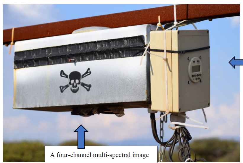
Savannah rangelands provide a significant source of income for rural communities, which use them to manufacture a variety of products. Traditionally, rangeland managers used visual and/or physical monitoring methods that were time-consuming, labour-intensive, and expensive. The applicability of these methods to assessing rangeland vegetation remains largely unknown. Photographs taken digital integrating analyzed qualitatively or statistically, and analysis can focus on individual species or integrate data from the entire field of view into a community or canopy-level picture. This technique attempts to bridge the gap between ground-based observations and satellite remote sensing. What motivated the review of this digital camera is that the system has proven to be inexpensive in other studies and because images can be analyzed either quantitatively or qualitatively, and the analysis can focus on individual species or integrate across the field of view or canopy-level perspective. Digital cameras were discovered to be scientific instruments capable of accurately estimating and measuring vegetation parameters only recently in crop sciences, where they are used to detect flowering success or track phenological stages in monospecific crop stands. By reducing the labour-intensive nature of monitoring at the field scale with camera-based remote sensing, these effective applications demonstrate the vast potential of camera-based remote sensing. Digital Image Analysis (DIA) offers a more continuous method of capturing data, storing and transferring it electronically to a computer, and processing it with image-analysis software. The number of data that can be collected each day at a given time is limited as opposed to visual estimations.
Keywords
- Digital cameras,
- Near-surface remote sensing,
- Technologies,
- Rangelands,
- Repeat photography
References
- Angassa, A., Sheleme, B., Oba, G., Treydte, A. C., Linstädter, A., Sauerborn, J. 2012. Savanna land use and its effect on soil characteristics in southern Ethiopia. Journal of Arid Environments, 81, 67-76.
- Bater, C. W., Coops, N. C., Wulder, M. A., Hilker, T., Nielsen, S. E., McDermid, G., Stenhouse, G. B. 2011. Using digital time-lapse cameras to monitor species-specific understorey and overstorey phenology in support of wildlife habitat assessment. Environmental monitoring and assessment, 180, 1-13.
- Bauer, S. D., Korč, F., Förstner, W. 2011. The potential of automatic methods of classification to identify leaf diseases from multispectral images. Precision Agriculture, 12, 361-377.
- Berra, E. F., Gaulton, R., Barr, S. 2017. Commercial off-the-shelf digital cameras on unmanned aerial vehicles for multitemporal monitoring of vegetation reflectance and NDVI. IEEE transactions on geoscience and remote sensing, 55(9), 4878-4886.
- Browning, D. M., Snyder, K. A., Herrick, J. E. 2019. Plant phenology: Taking the pulse of rangelands. Rangelands, 41(3), 129-134.
- Chianucci, F., Bajocco, S., Ferrara, C. 2021. Continuous observations of forest canopy structure using low-cost digital camera traps. Agricultural and Forest Meteorology, 307, 108516.
- Corti, M., Cavalli, D., Cabassi, G., Vigoni, A., Degano, L., Marino Gallina, P. 2019. Application of a low-cost camera on a UAV to estimate maize nitrogen-related variables. Precision Agriculture, 20, 675-696.
- Dube, T., Maluleke, X. G., Mutanga, O. 2022. Mapping rangeland ecosystems vulnerability to Lantana camara invasion in semi‐arid savannahs in South Africa. African Journal of Ecology, 60(3), 658-667.
- Engler, J. O., Abson, D. J., Feller, R., Hanspach, J., von Wehrden, H. 2018. A social-ecological typology of rangelands based on rainfall variability and farming type. Journal of Arid Environments, 148, 65-73.
- FAO. 2011. Rangelands and climate change: Mitigation, adaptation and co-benefits. Food and agriculture organization of united nations.27594-352
- Fernández, E., Gorchs, G., Serrano, L. 2019. Use of consumer-grade cameras to assess wheat N status and grain yield. PloS one, 14(2), e0211889.
- Gehrke, R., Greiwe, A. 2014. RGBI images with UAV and off-the-shelf compact cameras: An investigation of linear sensor characteristics. EARSeLeProceedings, 13(S1), 53-58.
- Gobbett, D. L., Handcock, R. N., Zerger, A., Crossman, C., Valencia, P., Wark, T., Davies, M. 2013. Prototyping an operational system with multiple sensors for pasture monitoring. Journal of Sensor and Actuator Networks, 2(3), 388-408.
- Handcock, R. N., Gobbett, D. L., González, L. A., Bishop-Hurley, G. J., McGavin, S. L. 2015. Combining multi-spectral proximal sensors and digital cameras for monitoring grazed tropical pastures. Biogeosciences Discussions, 12(21).
- Huete, A., Didan, K., Miura, T., Rodriguez, E. P., Gao, X., Ferreira, L. G. 2002. Overview of the radiometric and biophysical performance of the MODIS vegetation indices. Remote sensing of environment, 83(1-2), 195-213.
- Inoue, T., Nagai, S., Kobayashi, H., Koizumi, H. 2015. Utilization of ground-based digital photography for the evaluation of seasonal changes in the aboveground green biomass and foliage phenology in a grassland ecosystem. Ecological Informatics, 25, 1-9.
- Jia, B., He, H., Ma, F., Diao, M., Jiang, G., Zheng, Z., Fan, H. 2014. Use of a digital camera to monitor the growth and nitrogen status of cotton. The scientific world journal, 2014.
- Jiang, J., Zhang, Z., Cao, Q., Tian, Y., Zhu, Y., Cao, W. and Liu, X., 2022. Use of a digital camera mounted on a consumer-grade unmanned aerial vehicle to monitor the growth status of wheat. Journal of Nanjing Agricultural University, 42(4), pp.622-631.
- Maphanga, T., Dube, T., Shoko, C., Sibanda, M. 2022. Advancements in the satellite sensing of the impacts of climate and variability on bush encroachment in savannah rangelands. Remote Sensing Applications: Society and Environment, 25, 100689.
- Matope, A., Zindove, T. J., Dhliwayo, M., Chimonyo, M. 2020. Mitigating the effects of drought on cattle production in communal rangelands of Zimbabwe. Tropical animal health and production, 52, 321-330.
- Migliavacca, M., Galvagno, M., Cremonese, E., Rossini, M., Meroni, M., Sonnentag, O., Richardson, A. D. 2011. Using digital repeat photography and eddy covariance data to model grassland phenology and photosynthetic CO2 uptake. Agricultural and Forest Meteorology, 151(10), 1325-1337.
- Mkwanazi, M.V., Ndlela, S.Z. and Chimonyo, M., 2021. Indigenous knowledge to mitigate the challenges of ticks in goats: A systematic review. Veterinary and Animal Science, 13, p.100190.
- Nijland, W., De Jong, R., De Jong, S. M., Wulder, M. A., Bater, C. W., Coops, N. C. 2014. Monitoring plant condition and phenology using infrared sensitive consumer grade digital cameras. Agricultural and Forest Meteorology, 184, 98-106.
- O'connor, T. G., Puttick, J. R., Hoffman, M. T. 2014. Bush encroachment in southern Africa: changes and causes. African Journal of Range & Forage Science, 31(2), 67-88.
- Palmer, A. R., Fortescue, A. 2003. Remote sensing and change detection in rangelands. African Journal of Range and Forage Science, 21(2), 123-128.
- Perez, A. J., Lopez, F., Benlloch, J. V., Christensen, S. 2000. Colour and shape analysis techniques for weed detection in cereal fields. Computers and electronics in agriculture, 25(3), 197-212.
- Petach, A. R., Toomey, M., Aubrecht, D. M., Richardson, A. D. 2014. Monitoring vegetation phenology using an infrared-enabled security camera. Agricultural and forest meteorology, 195, 143-151.
- Putra, B. T. W., Soni, P., Marhaenanto, B., Harsono, S. S., Fountas, S. 2020. Using information from images for plantation monitoring: A review of solutions for smallholders. Information Processing in Agriculture, 7(1), 109-119.
- Rabatel, G, Labbé, S. 2016. Registration of visible and near infrared unmanned aerial vehicle images based on Fourier-Mellin transform. Precision agriculture, 17(5), 564-587.
- Rabatel, G., Gorretta, N, Labbé, S. 2014. Getting simultaneous red and near-infrared band data from a single digital camera for plant monitoring applications: Theoretical and practical study. Biosystems Engineering, 117, 2-14.
- Richardson, A. D. 2019. Tracking seasonal rhythms of plants in diverse ecosystems with digital camera imagery. New Phytologist, 222(4), 1742-1750.
- Richardson, A. D., Braswell, B. H., Hollinger, D. Y., Jenkins, J. P, Ollinger, S. V. 2009. Near‐surface remote sensing of spatial and temporal variation in canopy phenology. Ecological Applications, 19(6), 1417-1428.
- Ritchie, G. L., Sullivan, D. G., Perry, C. D., Hook, J. E, Bednarz, C. W. 2008. Preparation of a low-cost digital camera system for remote sensing. Applied engineering in agriculture, 24(6), 885-894.
- Sakamoto, T., Shibayama, M., Kimura, A, Takada, E. 2011. Assessment of digital camera-derived vegetation indices in quantitative monitoring of seasonal rice growth. ISPRS Journal of Photogrammetry and Remote Sensing, 66(6), 872-882.
- Sonnentag, O., Hufkens, K., Teshera-Sterne, C., Young, A. M., Friedl, M., Braswell, B. H., Richardson, A. D. 2012. Digital repeat photography for phenological research in forest ecosystems. Agricultural and Forest Meteorology, 152, 159-177.
- Stafford, W., Birch, C., Etter, H., Blanchard, R., Mudavanhu, S., Angelstam, P., Marais, C. 2017. The economics of landscape restoration: Benefits of controlling bush encroachment and invasive plant species in South Africa and Namibia. Ecosystem Services, 27, 193-202.
- Taugourdeau, S., Diedhiou, A., Fassinou, C., Bossoukpe, M., Diatta, O., N’goran, A, Faye, E. 2022. Estimating herbaceous aboveground biomass in Sahelian rangelands using Structure from Motion data collected on the ground and by UAV. Ecology and Evolution, 12(5), e8867.
- Tilahun, M., Angassa, A, Abebe, A. 2017. Community-based knowledge towards rangeland condition, climate change, and adaptation strategies: the case of Afar pastoralists. Ecological Processes, 6, 1-13.
- Tucker, C. J. 1979. Red and photographic infrared linear combinations for monitoring vegetation. Remote sensing of Environment, 8(2), 127-150.
- Von Bueren, S. K., Burkart, A., Hueni, A., Rascher, U., Tuohy, M. P, Yule, I. J. 2015. Deploying four optical UAV-based sensors over grassland: challenges and limitations. Biogeosciences, 12(1), 163-175.
- Ward, D. 2005. Do we understand the causes of bush encroachment in African savannas?. African Journal of Range and Forage Science, 22(2), 101-105.
- Zaller, J. G., Kerschbaumer, G., Rizzoli, R., Tiefenbacher, A., Gruber, E, Schedl, H. 2015. Monitoring arthropods in protected grasslands: comparing pitfall trapping, quadrat sampling and video monitoring. Web Ecology, 15(1), 15-23.
- Zerga, B. 2015. Rangeland degradation and restoration: A global perspective. Point Journal of Agriculture and Biotechnology Research, 1(2), 37-54.
- Zhang, H., Wang, L., Tian, T, Yin, J. 2021. A review of unmanned aerial vehicle low-altitude remote sensing (UAV-LARS) use in agricultural monitoring in China. Remote Sensing, 13(6), 1221.
- Zhang, J., Wang, C., Yang, C., Jiang, Z., Zhou, G., Wang, B., Shi, Y., Zhang, D., You, L. and Xie, J., 2020. Evaluation of a UAV-mounted consumer grade camera with different spectral modifications and two handheld spectral sensors for rapeseed growth monitoring: performance and influencing factors. Precision Agriculture, 21, pp.1092-1120.
- Nguy-Robertson, A.L., Brinley Buckley, E.M., Suyker, A.S. and Awada, T.N., 2016. Determining factors that impact the calibration of consumer-grade digital cameras used for vegetation analysis. International Journal of Remote Sensing, 37(14), pp.3365-3383.