Introduction
Geoconservation, or the protection of geodiversity, can be carried out through different tools or actions (Gray 2013; Brilha 2005; Reynard & Brilha 2018). It can be considered as the set of practices devoted to the recognition, protection, and promotion of valuable elements of geodiversity (or georesources) according to their intrinsic, ecological, cultural, scientific or aesthetic characteristics (Sharples 1995; Crofts & Gordon 2015; Prosser 2013) which are worthy of conservation. Some restricted approaches circumscribe geoconservation practices only to geoheritage, but others are wider because they include georesources beyond their level of recognition or legal protection (Gordon 2019).
Different geoconservation actions can be applied in natural areas, protected or not, and in urban areas (Pescatore et al. 2023). Either way, public decision-makers, education specialists, entrepreneurs, non-governmental organizations, and scientists should get involved in a committed way to guarantee geoconservation in a holistic manner. To do so, Motta García et al. (2020) suggest a chain of geoconservation composed of three steps that may be carried out sequentially or simultaneously: diagnosis, conservation, and promotion. Each step can be acknowledged as a link in the chain and includes several substeps. The diagnosis step refers mainly to the data collection performed by academics, the conservation step involves governmental managers whether the georesources hold a protection legal category or not, and the promotion step also requires private agents to spread geodiversity elements for educational, recreational or tourist purposes. If the implementation of these links is accomplished by the different types of actors, geoconservation may be reached in a complete and real way.
Under the wider concept of geoconservation, Schwarz & Coronato (2023) have identified several tools to achieve the recognition, protection and promotion of georesources: (a) legal actions such as the creation of natural protected areas, the designation of World Heritage Sites declared by UNESCO, the settlement of museums and any other regulations devoted to the sustainable use of resources, international agreements, worldwide celebrations, among others; (b) geotourism understood as the provision of interpretation facilities used to learn about Earth Sciences in geological or geomorphological interest sites; (c) geological parks; (d) geocircuits along roads or trails to appreciate landscapes; (e) scientific and academic actions, for instance, literature, events, research projects and networks; (f) non-formal education and interpretation based on pedagogical initiatives using didactic tools; and (g) exhibitions carried out by private institutions, permanent or itinerant. Each tool will depend on the type of georesource, the nature of the area and the conservation aims (Gray 2013).
Therefore, nature-based tourism together with the use of interpretation facilities are an example of geoconservation practices. Natural components of landscape are seen as tourist attractions suitable for enjoyment and contemplation as well as for outdoor lifestyles. This makes special sense in those territories with scarce human intervention that offer wild environments; even more if the landscapes include archetypal features, i.e., mountains, cold forests, lakes, and glaciers (Nogué 2007). Such is the case of Argentina, which has geodiverse landscapes due to its geographical extent, and the richness of geological resources and climates (Coronato & Schwarz 2022). Moreover, 92% of the population lives in urban areas that represent only 5% of the national territory (Ministerio del Interior de Argentina 2023).
The components available in all these natural landscapes are used for different purposes to promote regional development. Tourism is included among them, whether to strengthen established destinations or to release emerging ones. In this context, Argentina has designed a governmental planning program called La Ruta Natural (TNRP: The Natural Road program), launched in 2020 by the National Office of Tourism and Sports. It attempts to increase nature tourism along part of the present road network all around the country. One of its missions is to promote tourism for sustainable territorial development and to position the country as an international nature destination (Ministerio de Turismo y Deportes Argentina 2022).
Seventeen routes were laid out in different regions with specific natural identities. They promote circuits, experiences, and destinations, based on the natural values and attractions of each region (Fig.1). One of these is La Ruta del Fin del Mundo – The End of the World Route (EWR) – in Tierra del Fuego province which includes the itinerary Río Grande-Ushuaia. In this sense, the aim of this contribution is to analyze this itinerary following the geoconservation chain (Motta Garcia et al. 2020) because the road goes through geodiverse landscapes. We try to show how the steps and substeps of the chain are present in part of the EWR and why the program may be considered as a geoconservation tool even though it was not thought to be so.
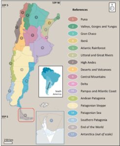
Figure 1. Map of Argentina showing the 17 regions where natural roads are designated by TNRP proposed by the National Office of Tourism and Sports (modified from Ministerio de Turismo y Deportes Argentina 2023). The red box indicates the region of Tierra del Fuego where the End of the World route extends.
Characterization of the study area
Tierra del Fuego is the southernmost province of Argentina. It is located between 53°–55°S/ 65°–68° W over 987.168 km² in the Isla Grande de Tierra del Fuego island, a subantarctic territory shared by Argentina to the east and Chile to the west. This island is the main one of the Fuegian Archipelago; it is surrounded by two interoceanic channels, the Magellan Strait, which separates the island from the South American continent, and the Beagle Channel, which separates it from the southern Chilean Archipelago. The Pacific and Atlantic oceans are to the west and east respectively (Fig. 2). The Argentine province has a low population density (5.1 inh/km2, Secretaría de Innovación Pública 2023) distributed in three cities: Río Grande, Tolhuin and Ushuaia. National and international tourism is one of the main economic activities because of the numerous and well-preserved natural attractions, its closeness to Antarctica and its geographical position at the end of the world.
The EWRP (Fig. 2A), our case study area, extends for 405 km along the National Road Number 3 (NR3) from Espíritu Santo Cape, at the southern side of the Magellan Strait up to Lapataia Bay on the Beagle Channel. In addition, the EWR includes 283 km of provincial unpaved roads and highlights the Río Grande-Ushuaia itinerary, starting and finishing in the two main cities of the province, and including twenty points of interest. It is 362 km long, crossing the province from north to south using paved NR3 as the main axis with short dirty detours to the east (PRA) and west (PRH). Out of this circuit several other outstanding points can be visited. This itinerary goes through different landscape units. It starts at the southern edge of the steppe flat plains and low ranges (Fig. 2B), where small basins contain seasonal and shallow lakes. A main river mouth develops an estuary environment fed by the inland precipitation and meltwater, and by high-amplitude oceanic tides. Southwards, the landscape shows rounded hills covered by deciduous forest and wide fluvial bottom valleys with grassed terrace systems (Fig. 2C). Glacial lakes are scattered in the landscape. This is a transitional region to the forested mountains, which prevail at the end of the circuit. Mountains with rocky peaks and summits, glaciers and high-altitude lakes surrounded by alpine-type vegetation above the treeline are abundant. Cascades and small creeks are visible on the slopes while rivers are along wide bottom valleys which are mostly covered by raised, red moss peatbogs with ponds (Fig. 2D). The coastal landscape shows different features depending on its location. On the one hand, the South Atlantic coast (Fig. 2E), appreciated along the first part of the itinerary, includes gravel beaches and berms, wide bays, rocky platforms and cliffs. On the other hand, glacial drumlins and moraines, small pocket gravel beaches, barriers, spits and deltas are developed along the Beagle Channel coasts (Fig. 2F), a subantarctic interoceanic passage surrounded by mountains, seen near the end of the itinerary.
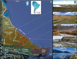
Figure 2. A) Tierra del Fuego map showing the complete EWR (in white), the studied itinerary between Río Grande and Ushuaia cities (in red) and the landscape units in the province, after Coronato (2014). The basic image was taken from Google Earth™. B) Río Grande estuary in the steppe plains. C) Meandering river flowing in a wide valley in the mixed hills and valleys unit. D) Glacial landscape in the forested southern mountains with valley bottoms covered by Sphagnum magellanicum raised bogs. E) Atlantic coast in a cliffed, erosional sector. F) Beagle Channel rocky coast in one of its deep entrances.
Methods
The geoconservation chain (Motta García et al. 2020) has been adapted by specifying the substeps and following the criteria shown in Table 1. The rows list step and substep definitions proposed in this paper, and the columns include two possible values: yes, if the substep is present, or no, if it is not. In the former, different categories can be used:
- local (L), provincial (P), national (N) or international (I) according to the geographical scale involved,
- direct (Di) or indirect (In) as regards the explicit mention of georesources.
If these categories are not completely represented in any of the substeps, they are indicated as:
- partially (p) in those cases in which the substep is not fully applied,
- in progress (ip) in those in which the substep is being developed.
This analysis matrix was applied to the study itinerary that was divided into six segments (Fig. 3A–E) according to key locations along the involved roads. The segmentation was a methodological decision made before gathering and analyzing the data; it allowed us to make a deeper and specific description of each substep, taking into account that the landscape seen through these roads has different and contrasting georesources.
The information used to assess each segment came from the available scientific literature, planning documents, field observations, imagery and cartography, as well as previous experience in the study area. The inventory substep was analyzed based on academic documents such as CSIGA (2008), Schwarz (2009; 2019), Flores Barrera (2020), Schwarz et al. (2023) and Coronato et al. (2022).
Table 1. Double-entry matrix considering the geoconservation steps and substeps (modified from Motta García et al. 2020) with their definitions and possible values.
Step | Substep | Definition | NO | YES | |||
Diagnosis | Inventory | Identification and location of georesources at different scales |
| L | P | N | I |
Characterization | Available knowledge based on scientific research |
|
| ||||
Quantitative assessment | Analysis through valorization scale based on criteria and hierarchization |
|
| ||||
Indications of use | Existence of planning tools and regulations according to land property status |
| Di | In | |||
Conservation | Recognition as a protected area | Legal instruments for protected areas |
| L | P | N | I |
Georesource conservation | Specific legal instruments for georesources |
| L | P | N | I | |
Monitoring | Control planning of the status of georesources |
|
| ||||
Promotion | Dissemination | Source |
| L | P | N | I |
Interpretation | Availability of facilities in-site or off-site |
|
| ||||
Educational use | Inclusion in different educational levels and plans |
|
| ||||
Tourist-Recreational use | Origin of users under tourist and recreational programs |
| L | P | N | I | |
For the value “Yes”, there are different possibilities: L: local, P: provincial, N: national, I: international, Di: direct, In: indirect.
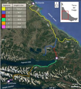
Figure 3. Tierra del Fuego map showing the Río Grande-Ushuaia itinerary and its segments as part of the EWR. NR3: national route #3, PRA: provincial route A, PRH: provincial route H. The basic image was taken from Google Earth™.
Results
After applying the double-entry matrix, we reached the results shown in Table 2. The diagnosis step is the best-achieved link of the chain of geoconservation. The inventories are local though several are partially done, just one segment has been included in a national inventory with only one georesource. Characterization is partly accomplished in four out of six segments and completely in two out of the six. Quantitative assessment has been executed in four segments and is only partial in two of them. In all cases, except part of one of them, indications of use are indirect because they refer to other associated components of the landscape, such as the forest, the native and exotic fauna or the wetlands, as well as land use regulations for private economic activities.
Table 2. Application of the double-entry matrix in each of the six segments of the itinerary Río Grande-Ushuaia, based on the available information used as sources.
Steps | Substeps | Segments of Río Grande – Ushuaia itinerary along the EWR | |||||
A | B | C | D | E | F | ||
Diagnosis | Inventory | L | L | L | L-p | L-p | L / N-p |
Characterization | Yes-p | Yes-p | Yes | Yes-p | Yes-p | Yes | |
Quantitative assessment | Yes | Yes | Yes | Yes-p | Yes-p | Yes | |
Indications of use | In | In | In | In | Di-p / In-p | In | |
Conservation | Recognition as a protected area | P-p / I-p | No | No | P-p | P-p | No |
Georesource conservation | No | No | No | No | P-p | No | |
Monitoring | No | No | No | No | No | No | |
Promotion | Dissemination | P-p / N / I-p | P-p / N | N | L-p / P-p / N | L / P / N/ I-p | L / P / N |
Interpretation | Yes-ip | No | No | Yes-p | Yes-p | Yes-p | |
Educational use | Yes | Yes | Yes-p | Yes | Yes | Yes | |
Tourist-Recreational use | L / P / N-ip / I-ip | L / P / N-ip | L / P-p / N-ip | L / P / N / I | L / P / N / I | L / P / N / I | |
The value “No” is colored red whereas the value “Yes” is green. The latter is specified when the substep is local (L), provincial (P), national (N) or international (I) as well as if it is direct (Di) or indirect (In); additionally, it can be partially (p) or in progress (ip).
The conservation step is the weakest link of the chain. Half the segments are partially recognized as protected areas, mostly by provincial regulations and one of them is internationally recognized as a Ramsar site because of the presence of migrating birds along the coastal landscape. Georesource conservation appears partially in only one segment with the protection of valley bottom peatbogs, under a provincial category. Monitoring is not applied along the itinerary, in any of the segments.
The promotion step is highly accomplished along the itinerary. Except for interpretation facilities in two segments, all the other substeps are reached. Dissemination is carried out by all source levels, especially from the provincial sphere. International dissemination is carried out partially in two segments due to the Ramsar site already mentioned and the use of a georesource as a worldwide recognized sky center. The national level is given by the fact that the itinerary is promoted by the national tourism board, which also designed a strategic long-term tourism plan including this region as a national and international destination. Interpretation is partially or in progress in most of the segments through viewpoints (Fig. 4A and B), panels (Fig. 4C to E), tourism guide narratives (Fig. 4F) and field guidebooks. The whole itinerary provides educational use for schools but also local, national, and international university and postgraduate students (Fig. 4G). As regards tourist and recreational use, the six segments welcome visitors of different origins. This substep is in progress in the northern part of the itinerary in subdued landscapes whereas it is consolidated in the southern forest mountainous area where the scenic route extends (Fig. 4H). The promotion step values different geodiversity elements, such as the Garibaldi Col (Fig. 4 A, F) used as the unique intermontane road-pass that connects the entire province; the glacio-tectonic basin of Fagnano Lake (Fig. 4 B, D, E) placed along the transform plate boundary between the South American (north) and the Scotia (south) tectonic plates; Olivia Mount (Fig. 4C) and Martial Cirque Glacier (Fig. 4H) in the Fuegian Andes range, showing its meta-sedimentary and volcanic rock complex, highly deformed and sculptured by glacial and gravitational processes.
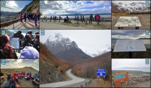
Figure 4. Promotion actions and facilities already developed along the segments of the EWR (see Fig. 3). A) (54°41'21.48"S- 67°50'28.24"W) and B) (54°35'9.66"S- 67°20'53.18"W): viewpoints used by tourists, locals, and students, located in segments E and D, respectively. C) ( 54°47'29.02"S- 68°23'21.98"W), D) ( 54°32'6.19"S- 67°13'39.77"W) and E) (54°35'7.42"S- 67°15'17.24"W): panels for environmental interpretation located in different landscapes, located in segments F and D. F) (54°41'21.48"S- 67°50'28.24"W): tourism guide narratives using public facilities and specific cartography, located in segment E. G) (53°41'21.22"S-67°50'49.51"W): educational use during open-air lessons for local university students, located in segment A. H) (54°46'23.86"S- 68°12'10.08"W): the beginning of the scenic route highlighting the Fuegian Andes mountains, located in segment E.
Concerning the segments themselves, segment E shows the best possibilities to reach geoconservation throughout the three steps if monitoring actions, the missing substep, were carried out. The most threatened segments seem to be B and C since they do not attain any conservation substep, moreover, they do not offer interpretation facilities. In segment F, likewise, none of the conservation substeps are being achieved; considering this part of the itinerary is included in an urban area with intense use and at the same time receives visitors from all over the world, the segment appears to be highly vulnerable.
TNRP highlights a list of “must-sees” as the essential places that should not be missed along the road and several key points through the itinerary. A comparison between all of them and the georesources already identified in the inventories (Table 3) shows that the studied itinerary could appraise many more elements to strengthen its aims, i.e., the nature-based tourism and the natural identity of this region. Among the georesources, landforms such as capes, marine beaches, rivers, dunes, and moraines can be identified as well as different rocky outcrops of varied ages, from the Upper Jurassic to the Holocene. These georesources provide an understanding of different endogenous and exogenous processes and systems and also the materials that compose them, e.g., sediments, rocks, and fossils. At the same time, they offer a great opportunity to let visitors learn about natural global changes related to tectonics and climate that occurred along the Earth´s history.
For segments A, B, C and D the program only mentions eight must-sees and key points, whereas inventories have identified more than 40 (Fig. 5). The most varied segment is E, named as a scenic road by TNRP. It goes through a forested mountainous landscape, taking advantage of the views and georesources of an archetypal landscape. Although segment A is the longest (at more than 100 km), the program identifies just three must-sees and key points; this segment is located along steppe plains and a hilly topography which are, precisely, in the antipodes of the archetypal landscape above mentioned. As seen in Fig. 5, a noticeable increase of elements from North to South between segments B and E may outcome from the fact that the itinerary goes into the mountains.
Table 3. Comparison between the must-sees and key points highlighted by TNRP and the georesources already inventoried along the itinerary.
Segments | Must-sees and key points | Georesources included in inventories |
A | 1. Río Grande city 2. Costa Atlántica reserve 3. San Pablo cape | 1. Grande river estuary 2. Ensenada La Colonia abrasion platform 3. San Luis lake 4. Punta María Holocen beaches 5. Punta María paleocape 6. Fuego River alongside the Atlantic coast 7. Auricosta cape and abrasion platform 8. Los Patos creek 9. Cabo Domingo rocky concretions 10. Ewan Norte river 11. Ewan Sur river 12. Río Chapel valley 13. Asturiana creek 14. Pirinaica creek 15. Pirinaica valley and Inés cape view 16. Ladrillero river 17. Ladrillero river storm berm 18. San Pablo dunes 19. San Pablo cape 20. San Pablo river |
B | 1. Corazón de la Isla reserve | 1. Clastic dykes 2. Ewan valley 3. Fossiliferous rocky outcrops 4. Chepelmut moraine 5. Pirámide mount 6. Aserradero river 7. Mimica valley |
C | 1. Tolhuin city | 1. Khamy creek 2. Rocky hills with glaciofluvial deposits 3. Cancio creek 4. Kettle holes 5. Tolhuin moraines 6. Michi mount 7. Varela lake 8. Negra lake |
D | 1. Fagnano lake 2. Jeujepen mount viewpoint 3. Río Valdez reserve | 1. Magallanes-Fagnano fault scarp 2. Fagnano lake 3. Cliffs at Fagnano lake 4. Storm berm at Fagnano lake 5. Turbio river mouth 6. Turbio delta 7. Indio lake 8. Jeujepen mount 9. Valdez river mouth 10. Beauvoir range |
E | 1. Andes Fueguinos scenic road 2. Escondido lake access 3. Garibaldi road pass 4. Submarino lake and cascade trail 5. Valle de Tierra Mayor reserve 6. Esmeralda lake trail 7. Turquesa lake trail 8. Valle Carbajal viewpoint 9. Olivia river 10. Velo de la Novia cascade trail | 1. Escondido lateral valleys 2. Garibaldi pass 3. Rancho Hambre lateral valley 4. Lasifashaj river 5. Krund mount 6. Esmeralda lake 7. Ojo del Albino glacier 8. Bonete mount 9. Tierra Mayor valley 10. Oyarzún peatbog 11. Carbajal valley 12. Olivia river 13. Olivia mount |
F | 1. Ushuaia city 2. Beagle channel | 1. Beagle channel 2. Olivia river mouth 3. Alarken mount 4. Ushuaia bay 5. Ushuaia peninsula 6. Andorra valley 7. Receding moraine 8. Martial glacier 9. Fuegian Cordillera 10. Susana mount |
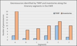
Figure 5. Quantity of natural attractions along the studied itinerary, comparing those pointed out by TNRP and those listed and described in the available inventories carried out for other geoconservation purposes. The georesource type and their names are shown in Table 3.
Final Remarks
According to TNRP (Ministerio de Turismo y Deportes Argentina 2022), nature-based tourism using the road network of Argentina can trigger several benefits to nature itself and local development. The 17 different roads designated by the program may bring the population closer to the natural world by appreciating and admiring its values through emotions, learning, and discovering. At the same time, the identity built through this close-up can lead to a better understanding of what and why to protect nature as a whole, including not only its biotic components but also the abiotic ones.
Following the wide approach of geoconservation, TNRP is considered a useful tool classified as a geocircuit although it points out biodiversity more than geodiversity. Abiotic elements are mainly highlighted according to their values as scenery and support for ecosystems and human activities. The intrinsic value of geodiversity is less recognized (Schwarz & Coronato 2023). Since geointerpretation could be promoted in this extreme latitude itinerary, it may also be considered as a geotrail or roadside geology (Sadry 2021). The former refers to self-guided offerings that let visitors experience natural sites on their own (Stolz & Megerle 2022). Roadside geology refers to a book series published in each state of the United States of America that allows people to visit sites along existing roads, according to Štrba et al. (2016). Likewise, the authors propose the concept of roadside geotourism which adds information about the abiotic attractions or stops located at or near the roads that leads to a much more valuable way of traveling and promotes public awareness of a region. Examples of this kind of tool are developed in Latin America. For instance, in Ecuador a geotouristic route was proposed by Carrión-Mero et al. (2020) to highlight georesources through a mining region; in Argentina, stratigraphic features of a rural area were suggested to enhance a geocircuit between the coast and the inland located at the oldest geological context of the country (Camino et al. 2018); in Chile, a paleontological georoad was designated after the diagnosis of a potential geopark fostering better conservation of geodiversity and better communal use in geological topics (Navarrete Luengo 2021). In all these cases, the tourist use of georesources is seen as a way to promote geoconservation. However, following Newsome and Dowling (2018), it is important to bear in mind that before any site can be developed for tourism, it should be first assessed in relation to its geological value for human society and its need for protection.
Although geoconservation and geotourism are not explicit in TNRP, its aim is to promote nature-based tourism, hence the studied itinerary is convenient to underpin the protection of valuable georesources in both subdued and archetypal landscapes of Tierra del Fuego. In fact, one segment of the itinerary is presented as a scenic road that seizes the role of geodiversity after its aesthetic value, coincident with archetypal georesources.
So far, the diagnosis step is the best-achieved link of the geoconservation chain. However, the itinerary includes just a few georesources with those that are already recognized in inventories. In this sense, nature-based tourism is underusing the geodiverse Fuegian landscapes. The strength of this step is given by the fact that geoconservation is internationally understood as a new geoscience (Henriques et al. 2011), being developed by national and local researchers during the last 15 years and matches the situation of most Latin American countries (Palacio Prieto et al. 2016b).
The conservation link is the weakest one. This may be the result of the lack of specific regulations devoted to the protection of abiotic components of nature in Argentina (Medina et al. 2016). In consequence, monitoring plans do not exist yet. The country holds a pioneer history in nature conservation in Latin America and has almost 550 natural protected areas that represent more than 16% of the continental territory (SIFAP 2023). However, the protection criteria have been on an ecological basis (Coronato & Schwarz 2022). A change of vision is needed in society, especially by legislators and decision-makers, to contemplate the importance of geodiversity not only after its aesthetic and supporting services but also after its intrinsic values. According to Palacio Prieto et al. (2016b), coordinated actions among local authorities, academia, NGOs and private agents are required to implement geoconservation under an integrated approach. Otherwise, the status of geoconservation seems to be fragile pointing out a certain degree of vulnerability.
The promotion step is well developed. Nevertheless, this is an indirect result of the tourist activity that promotes the region as an international destination based on the beauty of the natural environments at “the end of the world” as a destination brand. Likewise, the dissemination substep is done by private and public tourist actors at different scales, and also by educators and scientists in relation to educational use. This link of the chain is little carried out by environmental agents who have traditionally put their efforts in endangered species and ecosystems, not bearing in mind the key role of geodiversity.
The state of the geoconservation chain shown in this case study is similar to Brazil’s where surveys carried out reveal that the diagnosis step prevails in relation to conservation and promotion (Motta García et al. 2020). In both countries, the main actors involved in promotion come from tourism and education spheres, whereas diagnosis is made by multidisciplinary groups of academics. This reinforces that an integrated approach requires joint efforts between academia, public administrations, and society. In the same way, this need is present in other Latin American countries. In Colombia the geoconservation chain seems to be weak since there are few inventories despite the varied geological features they have, but conservation through legal instruments and local awareness of the importance of geodiversity is even weaker (Jaramillo Zapata et al. 2016). Mexican environmental legislation focuses on biodiversity; the promotion of geodiversity is limited and associated with biosphere reserves even though many of the main attractions of these natural protected areas are abiotic (Palacio Prieto et al. 2016a). Although Chile follows several international recommendations to protect geoheritage, national regulations have been slowly implemented (Mourgues et al. 2016); their diagnosis is the result of the personal interests of researchers instead of long-term public policies, and so it happens in México, where there are no systematic inventories with a unified methodology (Palacio Prieto et al. 2016a). On the contrary, Cuban governmental offices have been devoted to preparing an inventory of the mining and geological interest points, grouping academics and mining communities towards a conservation strategy (Guajardo & Costas 2014 as cited in Serra Díaz & Iturralde-Vinent 2016). Likewise, in Perú (Zavala Carrión 2016) a national office has recently been assigned the promotion of tourism and heritage to spread geological interest sites for geotourist activities such as guidebooks, georoutes and thematic maps; they are based on inventories that classify georesources into several types: natural or paleontological monuments, national sanctuaries, mining heritage and natural parks. In Argentina, the Geological and Mining Survey (SEGEMAR) made the first inventory of 72 geological interest sites in 2008 (CSIGA 2008) and has recently incorporated the identification and description of them in the official national geological cartography. In brief, in Latin American and Caribbean countries, including Argentina, geoheritage lacks specific regulations devoted to its protection. A reverse situation could allow proper management and conservation based on systematic scientific knowledge and promote the wise use of valuable georesources. Whereas the region is strongly geodiverse and the academic community is striving to inculcate the concept of geoconservation, the importance of geodiversity is not yet sufficiently acknowledged by the general public and it is softly taken into consideration by policymakers.
Back to our case study, to consider the Río Grande-Ushuaia itinerary as a tool for the geoconservation chain, many actions could be worked out by different actors. The itinerary could be reinforced if it was enlarged 25 km westwards including the Tierra del Fuego National Park which holds many protected georesources; more must-sees and key points could be incorporated using the georesources already inventoried and in consequence, this could nourish the promotion step. If this happened, more georesources would become more visible among visitors who may claim protection actions as well as interpretation facilities. Moreover, an intensified use of the itinerary may lead to the necessity to design and implement monitoring plans in order to guarantee the conservation status of the georesources.
To sum up, completing inventories, designing specific regulations for georesource conservation, carrying out monitoring, and increasing interpretation facilities are the main strategies to reinforce the chain of geoconservation all along the itinerary. This shows the reciprocal relationship between tourism and geoconservation since the former uses well-preserved georesources as natural attractions and the latter takes advantage of the promotion of valuable abiotic elements of the landscape for interpretation and recreation, encouraging local identity and sense of belonging. The wise use of TNRP, and particularly of the EWR, contributes to geoconservation and at the same time geoconservation is essential for nature-based tourism.
Acknowledgments
We kindly appreciate the editors for the invitation to present part of our research in this special volume on geoconservation in Latin America and the Caribbean. Anonymous reviewers' comments improved this paper.
References
Brihla J (2005). Património geológico e geoconservação: a conservação da natureza na sua verente geológica. 190 pages. Palimage.
Camino M, Happen K, Bó MJ, Meroi Arcerito F (2018). Sierra Bachicha: propuesta para un nuevo sitio de interés geológico rural en el partido de Balcarce, provincia de Buenos Aires. Serie Correlación Geológica. 34(1): 5–14. http://www.scielo.org.ar/scielo.php?pid=S1666-94792018000100001&script=sci_arttext
Carrión-Mero P, Ayala-Granda A, Serrano-Ayala S, Morante-Carballo F, Aguilar-Aguilar M, Gurumendi-Noriega M, Paz-Salas N, Herrera-Franco G, Berrezueta E (2020). Assessment of Geomorphosites for Geotourism in the Northern Part of the “Ruta Escondida” (Quito, Ecuador). Sustainability. 12(20): 8468. http://www.doi:10.3390/su12208468.
Coronato A (2014). Territorios fueguinos: fisonomía, origen, evolución. In Oría J & Tivoli A (Eds.). Cazadores de mar y tierra. Estudios recientes en arqueología fueguina. 43–63. Ed. Cultural Tierra del Fuego.
Coronato A, Schwarz S (2022). Approaching geodiversity and geoconservation in Argentina. International Journal on Geoheritage and Parks. 10(4): 597–615. https://doi.org/10.1016/j.ijgeop.2022.08.011
Coronato A, Schwarz S, Flores Barrera F (2022). Glacial landforms as geodiversity resources for geotourism in Tierra del Fuego, Argentina. Quaestiones Geographicae. 41(1): 5–24. https://doi.org/10.2478/quageo-2022-0001
Crofts R, Gordon JE (2015). Geoconservation in protected areas. In Worboys GL, Lockwood M, Kothari A, Feary S & Pulsford I (Eds.). Protected area governance and management. 531–568. Canberra: ANU Press.
CSIGA (Comisión de Sitios de Interés Geológico de la Argentina) (2008). Sitios de interés Geológico de la República Argentina: Los geólogos nos cuentan. (Vol. 46, I & II). Buenos Aires: Servicio Geológico Minero Argentino. https://repositorio.segemar.gov.ar/handle/308849217/1305
Flores Barrera F (2020). Geoturismo urbano: una propuesta para diversificar la oferta turístico-recreativa en Ushuaia. Dissertation, University of Patagonia San Juan Bosco.
Gordon J (2019). Geoconservation principles and protected area management. International Journal of Geoheritage and Parks. 7(4): 199–210.
Gray M (2013). Geodiversity: valuing and conserving abiotic nature. 495 pages. John Wiley and Sons.
Henriques MH, dos Reis RP, Brilha J, Mota T (2011). Geoconservation as an emerging geoscience. Geoheritage. 3: 117–128. https://doi.org./10.1007/s12371-011-0039-8
Jaramillo Zapata J, Castro Quintero N, Caballero Acosta JH & Molina Escobar JM (2016). Colombia. In Palacio Prieto JL (Coord.). Patrimonio geológico y su conservación en América Latina. Situación y perspectivas nacionales. Colección Geografía para el Siglo XXI. Series Libros de investigación. 18:121-148. Universidad Nacional Autónoma de México-Instituto de Geografía. México D.F.
Medina W, Vejsbjerg L, Aceñolaza G (2016). Marco legal de la geoconservación. Presencia de la geología en las leyes de áreas protegidas de la República Argentina. Revista del Museo Argentino de Ciencias Naturales. 18(1): 53–64.
Ministerio del Interior de Argentina (2023). Población urbana en Argentina. Evolución y distribución espacial a partir de datos censales. (https://www.argentina.gob.ar/sites/default/files/poblacion_urbana_dnp.pptx_.pdf). Retrieved June 1, 2023.
Ministerio de Turismo y Deportes Argentina (2022). Argentina. La Ruta Natural (https://larutanatural.gob.ar/es). Retrieved May 25, 2023.
Motta Garcia M, Leite Mansur K, Leite do Nascimento M, Fraga de Araújo Pereira R (2020). Geoconservation strategies framework: analysis from case studies in Brazil. ProGEO News. 1: 4–5.
Mourgues FA, Contreras K, Schilling M (2016). Chile. In Palacio Prieto JL (Coord.). Patrimonio geológico y su conservación en América Latina. Situación y perspectivas nacionales. Colección Geografía para el Siglo XXI. Series Libros de investigación. 18: 81–120. Universidad Nacional de México-Instituto de Geografía. México D.F.
Newsome D, Dowling R (2018). Geoheritage and Geotourism. In Reynard E , Brilha (Eds). Geoheritage. Assessment, Protection and Management. 305–321. Elsevier. https://doi.org/10.1016/B978-0-12-809531-7.00017-4
Nogué J (2007). Territorios sin discurso, paisajes sin imaginario. Retos y dilemas. Ería. 73-74: 373–382.
Palacio Prieto JL, Gaitán J, Sahagún Becerra Y (2016a). México. In Palacio Prieto JL (Coord.). Patrimonio geológico y su conservación en América Latina: Situación y perspectivas nacionales. Colección Geografía para el Siglo XXI. Series Libros de Investigación. 18: 191–215. Universidad Nacional Autónoma de México-Instituto de Geografía. México D.F.
Palacio Prieto JL, Sánchez Cortez JL, Schilling ME (2016b). Presentación. In Palacio Prieto JL (Coord.). Patrimonio geológico y su conservación en América Latina: Situación y perspectivas nacionales. Colección Geografía para el Siglo XXI. Series Libros de Investigación. 18: 9–14. Universidad Nacional Autónoma de México-Instituto de Geografía, México D.F.
Pescatore E, Bentivenga M, Giano SI (2023). Geoheritage and Geoconservation: some remarks and considerations. Sustainability. 15(7): 5823. https://doi.org/10.3390/su15075823
Prosser CD (2013). Our rich and varied Geoconservation portfolio: the foundation for the future. Proceedings of the Geology Association. 124: 568–580. https://doi.org/10.1016/j.pgeola.2012.06.001
Reynard E, Brilha J (2018). Geoheritage: Assessment, Protection, and Management. 482 pages. Elsevier.
Sadry B (2021). The geotourism industry in the 21st century. The Origin, Principles, and Futuristic Approach. Apple Academic Press. Retrieved from https://www.perlego.com/book/1695186/the-geotourism-industry-in-the-21st-century-the-origin-principles-and-futuristic-approach-pdf
Schwarz S (2009). Análisis de potencialidad de geositios para la conformación del Geoparque Andes Fueguinos. Dissertation, University of Patagonia San Juan Bosco.
Schwarz S (2019). Geodiversidad en el centro y norte de Tierra del Fuego. Recursos para un potencial desarrollo geoturístico. Dissertation, University of La Plata. https://doi.org/10.35537/10915/75800
Schwarz S, Coronato A (2023, in press). La geoconservación en Argentina. Desde la esfera internacional a la nacional. In El Patrimonio geológico de los Valles Calchaquíes-NO de Argentina. San Miguel de Tucumán: UNT.
Schwarz S, Labrone S, Coronato A, Flores Barrera F, Guerrero Gallardo G, Salemme M (2023). Análisis de georrecursos culturales para el uso turístico. Aplicación de una propuesta metodológica en el norte de Tierra del Fuego (Argentina). Serie de Correlación Geológica. 38 (2): 65–89. https://doi.org/10.5281/zcnodo.7738470
Secretaría de Información Pública (2023). Provincia de Tierra del Fuego, Antártida e Islas del Atlántico Sur (https://www.argentina.gob.ar/tierradelfuego). Retrieved August 14, 2023.
Serra Díaz AA, Iturralde-Vinent MA (2016). Cuba. In Palacio Prieto JL (Coord.). Patrimonio geológico y su conservación en América Latina. Situación y perspectivas nacionales. Colección Geografía para el Siglo XXI. Series Libros de investigación. 18: 149–170. Universidad Nacional Autónoma de México-Instituto de Geografía. México D.F.
Sharples C (1995). Geoconservation in forest management - principles and procedures. Tasforests. 7: 37–50.
SIFAP (Sistema Federal de Áreas Protegidas) (2023). Áreas protegidas. (https://sifap.gob.ar/areas-protegidas). Retrieved June 13, 2023.
Stolz J, Megerle H (2022). Geotrails as a medium for education and geotourism: Recommendations for quality improvement based on the results of a research project in the Swabian Alb UNESCO Global Geopark. Land. 11(9): 1422. https://doi.org/10.3390/land11091422
Štrba L, Baláž B, Lukáč M (2016). Roadside geotourism – an alternative approach to geotourism. e-Review of Tourism Research. 13(5/6): 598–609.
Zavala Carrión B (2016). Perú. In Palacio Prieto JL (Coord.). Patrimonio geológico y su conservación en América Latina. Situación y perspectivas nacionales. Colección Geografía para el Siglo XXI. Series Libros de Investigación. 18: 217–246. Universidad Autónoma de México-Instituto de Geografía. México D.F.