Geoheritage Values of the Northeastern Carpathians, Transcarpathia, Ukraine
- Sandor Gonczy * ORCID 1
- Gyula Fodor ORCID 1
- Natalia Olah ORCID 1
- Tibor Nagy ORCID 1
- Zsuzsanna2 Ãsik ORCID 2, 3
- János Szepesi 3, 4
Abstract
Transcarpathia politically is the westernmost county of Ukraine but geographically is the northâeastern part of the CarpathianâPannonian Region. The aim of our present work is to provide a brief overview and greater publicity about the geoheritage values of Transcarpathia using 45 documented geosites (stratigraphic, volcanic, geomorphological, mineralogical, tectonic) of the Ukrainian State Geological Survey. Four objects are located in national parks or nature reserves. The other 41 sites are only recommended for protection. The applied classification scheme included thematic (primary and additional interest) and functional categories (e.g. natural outcrops, quarries). The preliminary qualitative site assessment involved the determination of integrity, geological diversity, use limitations, current observation conditions, vulnerability, safety, association with other values parameters. This review is a good methodological starting point for expanding the database and emphasizing the importance of the abiotic nature. Conserving geodiversity requires protection for nationally or regionally important objects what includes active management of sites. Introduction
Geodiversity has been defined as the natural range (diversity) of geological (rocks, minerals, fossils), geomorphological (landforms, topography, physical processes), soil and hydrological features (Gray 2014; Neches 2016). Geodiversity provides essential goods and services for society as a nonrenewable asset (Gordon 2012). The in-situ occurrences of geodiversity elements with high scientific values (Brilha 2016) require protection. Geoconservation (Brocx & Semeniuk 2007) as an underestimated segment in nature conservation (Neches 2016) conserves endangered sites and raises awareness among local communities and organizations at different levels (national, international). Â
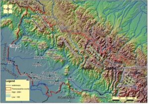
Transcarpathia is a county of Ukraine including the northeastern territory of the Carpathian Mountains (Fig. 1, 2). The region represents remarkably rich geodiversity as emphasized by a long geological history and diverse lithological formations ( ÅlÄ czka et al. 2007; GÅgaÅa et al. 2012; Nakapelyukh et al. 2018). The rocks comprise those of sedimentary (CretaceousâPaleogene, HajdúâMoharos 1997; Hnylko 2018), volcanic (Pécskay et al. 2000; Seghedi et al. 2001; Gönczy 2016) and hydrothermal origin (Lazarenko 1963; Vityk et al. 1994; Sergey & Skakun 2000). The current highâaltitude landforms (above 1000 m a.s.l., Fig. 1) represent the effect of the Quaternary glaciation. The geodiversity of the region has affected human activities from Paleolithic times with the manufacture of obsidian and quartzite tools (Rácz 2018) and has supported industrial development since the Middle Ages (Richthofen 1860, Schafarzik 1904). Despite the recent achievements in geoheritage inventory work (Manyuk 2006, 2016, 2020; Manyuk et al. 2020), the protection of abiotic nature is not a well applied concept in Ukraine where conservation is mainly focused on biotic phenomena (e.g. Kricsfalusy 2003).
Based on this, our study aims to emphasize the significance of geodiversity in a developing country to avoid major loss of abiotic diversity. In the absence of a complex geoheritage-related regional database, we used the inventory of representative geological landmarks compiled by the Ukrainian State Geological Survey (45 objects, Kalinin et al. 2006). Although this is a limited number considering the size of the county, it covers all major geological formations. To give a current geoheritage-based description of the outcrops, assessment indicators from the scientific assessment methodologies (Brilha 2016; VujiÄiÄ et al. 2011) were used, highlighting objects for (geo) tourism development or geoconservation actions.
Â
 Â Â Â Â Â Â Â
      Â
                    Â
        Figure 1. Topographical sketch of Transcarpathia Digital Elevation model: SRTM 1 arc sec (https://lta.cr.usgs.gov/SRTM1Arc)
                     Â
 Geodiversity of Transcarpathia
Transcarpathia covers an area of 12,800 km2 and consists mainly of mountainous (~80%) and lowland (~20%) areas (Gönczy 2014). The contiguous, wall-like mountain range of the Northeastern Carpathians rises above 2000 m (Fig. 1) and forms the northeastern border of the Carpathian Basin (HajdúâMoharos 1997). It separates the Tisa catchment from that of Vistula, Dniester, Prut and Siret (Fig. 1). The mountainous areas are very diverse considering the lithological and morphological conditions. They mainly comprise MesozoicâPaleogene sedimentary (flysch, sandstone, silt, shales, salt) and Miocene volcanic (andesites, dacites, rhyolites) formations (Titov et al. 1979; Glushko & Kruglov 1986; Kuzovenko et al. 2001; Matskiv et al. 2008). Older lithological associations are also present with subordinate limestone (Svaliava, Perechyn) and metamorphic formations (Marmarosh massif). Figure 1. Topographical sketch of Transcarpathia Digital Elevation model: SRTM 1 arc sec
Â
Â
Â
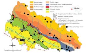
Figure 2. Geologicalâtectonical sketch of Transcarpathia (based on Gönczy 2016). Black dots indicate studied geoheritage values from the inventory of the Ukrainian State Geological Survey (Kalinin et al. 2006)
Â
The three major geomorphological regions (Figs 1, 2) reflect that the lithological conditions can be divided into the mid-height volcanic range (around 1000 m a.s.l.) and the high-altitude alpine and watershed region that is formed from flysch and molasse sediments. The length of the VihorlatâGutin volcanic range is approx. 120 km (in Ukraine) and the maximum width is 15â20 km (Malejev 1964; Gönczy 2016). The altitude is 700â800 m, but some peaks are just over 1000 m. The major volcanic edifices are andesitic composite volcanoes (Antalovski, Hotar, ObavskiâKamen, Demianov, MartinskiâKamen, Bujora, Tolstoi, Fig. 1) where erosion usually has revealed the subvolcanic root regions (Lexa et al. 2010). Due to the slightly younger calc-alkaline andesitic (arc type) volcanism (9.1â11.6 Ma, Pécskay et al. 2000; Gönczy 2016) compared to the Pannonian basin the erosional landforms are more intact (Karátson 1996, 1999, 2007). Smaller volcanic remnants (Kosino, Bijhany; Ricthofen 1860; Kulcsár 1943, 1968) of various ages (11.5â12.6 Ma, Pécskay et al. 2000) and origins (domes, ignimbrites) are scattered throughout the lowland areas. These are the members of the so-called Beregovo Hills mineralized caldera system (Lazarenko 1963; Vytik et al. 1994). Andesites are also present, forming variable eroded volcanic remnants (Chorna Gora â 568 m, Shalanky Hill â 372 m).
Next to the volcanic range, the flysch nappes frame the outer side of the mountains (e.g. Krosno, Duklya, Fig. 2) without interruption, but in a narrowing band (from 120 to 30 km) to the southeast (HajdúâMoharos 1997). It is composed of CretaceousâPaleogene sediments that were thrust during the PaleogeneâMiocene orogenic phases (Schmid et al. 2008, Seghedi et al. 2001, Shlapinskyi 2018). The narrow, striking nappes moved toward the outer foreland; the amplitude of each shift can reach 15â20 km. The alpine ridge (local name is âPoloninaâ) is a remnant of former pediment surfaces formed during the regional uplift and cut by right tributaries of the Tisa river (Fig. 1). From NE to SW the ridges are Polonina Runa (1479 m), Polonina Borzsava (Stoj â 1681 m), Polonina Krasna (Siglansky â 1563 m), Svidovec (Bliznica â 1881 m) and the last is Csornohora beyond the Black Tisa Valley. The top (Hoverla â 2061 m) is the highest peak of Ukraine (Fig. 1).
The watershed ridge (Verkhovyna) is also formed on flysch but lies beyond the borders of Transcarpathia. It includes the Eastern Beskids and the Gorgany. These ranges are cut by mountain passes of different heights at headwaters of larger rivers. These are the Uzhok Pass (889 m), the Verecke Pass (841 m) and the Yablunytsia Pass (931 m).
The three mountain ranges (volcanic, alpine, watershed) listed above are separated by longitudinal valleys along the nappe fronts (Figs 1, 2) where these ranges or valleys are crossed by a larger river, small basins have formed (Perechyn, Svaliava, Yasinia).
The lowland areas (~20%) can be divided into the Chop-Mukachevo plain (Fig. 1) and the Marmarosh basin. The larger Chop-Mukacsevo plain covers an area of approx. 2000 km2Â and joins the Great Hungarian Plain (toward Hungary) in the south and southeast. The plain has a uniformly flat surface (alt. 100â120 m), and rises only 5-6 m above the level of the Tisa where the high floodplains and terraces are characteristic. The smaller Solotvyno (or Marmarosh) basin (ca. 50 x 20 km) passes through the volcanic and flysch formations (Fig. 2). Â It is connected to the ChopâMukachevo plain through the so-called Khust gate. The basin is composed of Miocene sandâclay and volcanic formations, containing the largest salt deposits.
The north-eastern Carpathians are enriched by several minerals, natural gas, oil, lignite, lignite, iron, manganese, kaolin, bentonite, zeolite deposits. Salt is connected to the Solotvyno area (Fig. 1), where abandoned halls of the salt mines are used for medicinal purposes. The volcanic (Beregovo, Gutin) and crystalline zones (Radna) are famous for ore mineralization. The volcanic rocks are important in the building industry and road construction. Natural resources include hundreds of mineral springs (e.g. Svaliava, Shayan).
Â
Nature conservation in Ukraine
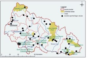
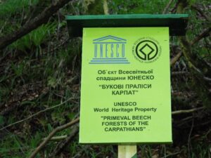
Protected natural areas of Ukraine encompass terrestrial (3.98%) and water territories (3.42%, protectedplanet.org). They are designated to preserve the natural variety of landscapes and the genuine fauna and flora, supporting general ecological diversity. According to the major IUCN categories (IâV), the number of these areas was over 5000 in 2019 (protectedplanet.org). The current network of Carpathian protected areas (Fig. 3) includes seven categories such as 1) nature reserve, 2) biosphere reserve, 3) nature park, 4) regional landscape park, 5) partial reserve, 6) natural monument, 7) protected site (Kricsfalusy 2003). These are mainly connected to the mountain range regions (e.g. Gorgany Nature Reserve; Synevyr National Nature Park, Fig. 3). The largest and most interesting site among them is the Carpathian Biosphere Reserve (53360 ha, established in 1992), and which received the European Diploma of Protected Areas in 1998. As a UNESCO world heritage site, the Ancient and Primeval Beech Forests of the Carpathians and Other Regions of Europe were declared as a transnational composite nature site (2011, Fig. 4) encompassing beech forests in 12 European countries (whc.unesco.org).
The protection of geological values is declared in the "Law of Ukraine on the Ukrainian Nature Conservation" (https://zakon.rada.gov.ua/laws). However, this law speaks of natural values, and there is no separate legislation on geological values. The 45 geological landmarks declared in Transcarpathia (Kalinin et al. 2006), based on their importance of the sites, can be divided into categories of state and local significance. Four of them are protected by law, as they are located in natural reserves. The remaining 41 objects were recommended for protection by the Geological Survey, but without any progress to date.
Â
Â
Figure 3. Nature conservation areas of Transcarpahia (based on Berghauer & Nagy 2013): the Gorgany Nature Reserve, the Carpathian National Nature Park, the Synevyr National Nature Park, the Uzhanskyi National Nature Park, the Vyzhnytsia National Nature Park, the Skole Beskyd National Nature Park, the Halych National Nature Park, the Hutsulshchyna National Nature Park, the Zacharovanyi Krai National Nature Park, the Sian Regional Landscape Park, the Prytysianskyi Regional Landscape Park.  Black dots indicate studied geoheritage values from the inventory of the Ukrainian State Geological Survey (Kalinin et al. 2006)
Â
Â
Figure 4. UNESCO World Heritage Property: Primeaval beech forests of the Carpathians.
Â
Â
Methods
Geodiversity of Transcarpathia has been studied by several thematic research projects of the Ferenc Rakóczi II Transcarpathian Hungarian College of Higher Education. For example, the volcanic sites were re-investigated by detailed fieldwork, physical volcanology and geochemical studies (Gönczy et al. 2014; Gönczy 2016) compiling a more detailed database. Salt is a special mineralogical resource of Transcarpathia (Hnylko 2013; Khrushchov et al. 2016). The karstic collapse features have also been surveyed since 2016 (Móga et al. 2017; 2019; Kurtyák et al. 2017; Gönczy et al. 2018). Other issues were investigated by educational and/or tourism projects (Molnár & Gönczy 2002; Sass 2017; Sass & Berghauer 2019). These ongoing field surveys form the basis for a complex geoheritage evaluation of geological landmarks (Kalinin et al. 2006). The applied classification scheme includes thematic and functional categories (Fuertes-Gutiérrez & Fernández-MartÃnez 2010). The preliminary assessment used indicators from published methodologies (Brilha 2016; VujiÄiÄ et al. 2011) involving the determination of integrity, geological diversity, use limitations, current observation conditions, vulnerability, educational potential, safety, association with other values parameters. The basic description of sites is attached (Table 1).
Â
Table 1. Characteristics of Transcarpathia geosites: summary of major and additional interest geology, protection, accessibility and use limitations featuresÂ
Geosite | Major and Additional Interest | Geology | Protection | Accessibility and Use Limitation |
1. Radvanske andesite outcrop | volcanology | basaltâandesite lava, 11.5 ± 1.6 Ma, part of the Antalovski composite volcano | not protected | accessible, in the vicinity of the E58 road, |
2. Nevicke, volcanic tuff columns | volcanology geomorphology | agglomerate type andesite tuff, part of the Antalovski composite volcano | not protected | accessible, in the vicinity of the H13 road, |
3. Vorochovski Cliffs | volcanology geomorphology | Andesite lava flow, part of the Antalovski composite volcano | not protected | hardly accessible, only dirt road |
4. Novoselytsya quarry | tectonics stratigraphy | Exposure of the Pienini clippen belt (LowerâMiddle Jurassic period) | not protected | hardly accessible, only dirt road |
5. Lumshorskiy Waterfall (Fig. 6h) | geomorphology | The waterfall was formed on layers of Duklya nappe, MiddleâUpper Eocene sandstone, flysch, gravel and clay. | not protected | accessible, by road until Lumshorski than on foot, frequented touristic site |
6. Olistoliths in Oligocene sediments (Uzhok) | tectonics | wedged limestone blocks between the Oligocene sediments (sandstone, clay, siltstone, conglomerate) of the Krosno nappe | not protected | accessible with short walk at the intersection of the H13 main road and the T0722 road, |
7. Shypot Waterfall | geomorphology | fault scarp on the Oligocene Malovizsenskaya Formation (sandstone, clayey flysch) of the Dukla nappe | not protected | accessible only by foot (7 or 12 km hike), frequented touristic site |
8. Mukachivska Castle (Fig. 6c) | volcanology geomophology | monogenetic dacite lava dome remnant | not protected | well accessible on paved road, frequented touristic site |
9. Kolchynske exposure of andesite tuff | volcanology | andesitic epiclastic sediments of Pannonian age | not protected | roadside exposure along E471, heavy traffic (safety) problem |
10. Klenovetske exposure of columnar andesites | volcanology | columnar jointed andesite of Pannonian age (9.7 ± 0.26) | not protected | accessible, 5 km drive on paved road from the E471 |
11. Ancient gold mine (Muzsievo) | mineralogy | more than 1000 m long underground mine (14â16th century) with polymetallic ores in highly altered silicic volcanic rocks | not protected | cannot be visited |
12. Ancient kaolinite quarry âKuklyaâ | mineralogy | kaolin quarry (17â18th century), in highly altered, metasomatic Sarmatian rhyolite tuff | not protected | cannot be visited |
13. Rhyodacite extrusion (Muzsievo) | volcanology | cryptodome intrusion in Sarmatian rhyolite tuff | not protected | accessible along road M23 |
14. Perlite quarries (Kvasovo) | volcanology | Sarmatian glassy lava domes and silicic volcaniclastics | not protected | cannot be visited |
15. Ancient underground adit in Dobrosillya (Bene) village | mineralogy volcanology | underground iron ore (limonite, goethite) mine (17â18th century) in altered, Sarmatian rhyolite tuff, | not protected | collapsed entrance |
16. Kvasivske outcrop of hydrothermal quartzites | mineralogy, geomorphology | Silicified deposits in Sarmatian rhyolite tuff | not protected | accessible by foot |
17. Basaltic andesite dyke (Suskovo) (Fig. 6e) | volcanology | Shallow subvolcanic body of the Lower Pannonian age (11.22 ± 1.37 Ma) intruded into a CretaceousâPaleogene flysch (Suha nappe) | not protected | accessible along road M06 |
18. Siltse, volcanic neck (Fig. 6f) | volcanology | Pannonian basaltic andesite volcano remnant | not protected | cannot be visited, operating quarry |
19. Zacharovana Dolina (Enchanted Valley, Fig, 6j) | mineralogy geomorphology volcanology | cliffs prepared from hydrothermally altered andesitic volcaniclastics | national park | accessible by foot, no restrictions, frequented touristic site |
20. Ilnytske outcrop of brown coal (lignite) | mineralogy stratigraphy | Lignite deposits of Pliocene age | not protected | accessible, no restrictions |
21. Volcanic outcrop âChorna Goraâ (âBlack Hillâ, Fig. 6d ) | volcanology | Sarmatian â Lower Pannonian (12.5 ± 0.9, 11.3 ± 1.6 Ma) andesitic stratovolcano remnant (with subordinate rhyolites) | not protected | accessible, no restrictions, frequented touristic site |
22. Eocene olistoliths (Nyzni Vorota) | tectonics | Eocene carbonate olistoliths in the Oligocene Krosno flysch nappe | not protected | roadside exposure, heavy traffic (safety) problem |
23. Pryborzhavske outcrop | tectonics, stratigraphy | Upper Jurassic â Lower Cretaceous limestone and marl of the Pieniny Klippen Belt with mollusc fauna | not protected | cannot be visited, operating quarry |
24. Chervona Skelya (âRed Cliffâ) Stream | volcanology, geomorphology | Sarmatian â Lower Pannonian basaltic andesite tuff with red weathered crust | not protected | accessible, no restrictions |
25. Sokyrnytske zeolite outcrop | mineralogy | Zeolite exposure in Miocene clay, siltstone, sandstone, conglomerate and tuffite environment | not protected | cannot be visited, operating quarry |
26. Golyatinske Cretaceous rocks outcrop | stratigraphy | Upper Cretaceous flysch with red clay deposits in the Oligocene Krosznó nappe assemblages | not protected | accessible, no restrictions |
27. Soymynske Eocene sediments outcrop | stratigraphy | Eocene flysch in the Oligocene Krosznó nappe assemblages | not protected | accessible, no restrictions |
28. Synevir Lake (Fig. 6g) | geomorphology | A lake formed 10â12Â 000 years ago with landslide origin | national park | accessible, no restrictions |
29. Exposure of the Marmaroshski Cliffs Zone | tectonics, stratigraphy | Exposure of the Lower Cretaceous Sojmulsky Formations in the Marmaroshski Cliffs Zone | not protected | accessible, roadside exposure along T0720 |
30. âDruzhbaâ (âFriendshipâ) Cave | geomorphology  | A 1 km long cave formed in Jurassic limestone wedged between the Lower CretaceousâPaleogene sediments of the Marmaroshski Cliffs Zone | Carpathian Biosphere Reserve | accessible, guided tours only, |
31. Cliff âKamyani Vorotaâ (âStone Gatesâ) | geomorphology stratigraphy | Jurassic limestone gate in the Lower Cretaceous â Paleogene sediments of the Marmaroshski Cliffs Zone | Carpathian Biosphere Reserve | accessible, no restrictions, frequented touristic site |
32, Novoselytske Jurassic sediments outcrop | tectonics, stratigraphy | Wedged Jurassic sediments with basaltic dykes in Lower CretaceousâPaleogene sediments of the Pieniny Klippen Belt | not protected | accessible, no restrictions |
33. Upper Cretaceous sediments outcrop Novoselytsya village | tectonics, stratigraphy | Chalk exposure in the Pieniny Klippen Belt | not protected | accessible, no restrictions |
34. Displacement circus (Bilovartsi) | tectonics, stratigraphy | Ca. 100 year old, 1 km long, 30â35 m deep, 20 ha area landslide form in the sandy, clayey sediments of the Upper Badenian Marmarosh Basin | not protected | accessible, no restrictions |
35, Solotvino, Salt outcrops (Fig. 6i) | geomorphology mineralogy  | Badenian salt outcrops around Solotvino | not protected | accessible, no restrictions |
36. Svidovetski cliffs, glacial relief (Fig. 6a) | stratigraphy mineralogy  | A glacier surface was formed during the Würm glacial in the Middle CretaceousâLower Paleogene flysch sediments of Dukla nappe | not protected | accessible, no restrictions, frequented touristic site |
37. Shypotska Suite outcrop (Fig. 6b) | stratigraphy, mineralogy  | Exposure of the Lower Cretaceous Sipoti formation of the Csornohora nappe (silicified clayâflysch) | not protected | accessible, no restrictions |
38. Trostyanets Cliffs (Kvasy Village) | volcanology | Wedged Late Jurassic basalt, gabbro from the sediments of the Porkuleci Nappe (Middle Cretaceous â Paleogene flysch) | not protected | accessible, no restrictions |
39. Exposure of Kamyanopototsky nappe (Rakhiv city) | stratigraphy, volcanology | Upper Jurassic â Lower Cretaceous basaltic lava and volcaniclastic assemblages with limestones and calcareous clays | not protected | accessible, no restrictions |
40. Rocky cliff (PermianâTriassic rocks outcrop, Rakhiv city) | stratigraphy | Polymictic quartz conglomerate, gravel, sand, silicic volcaniclastics in the Marmarosh crystalline massif | not protected | accessible, no restrictions |
41. Triassic rocks outcrop (Rakhiv city) | stratigraphy | Sand, quartz conglomerate, gravel, clay from the Ladinian stage (Triassic) | not protected | accessible, no restrictions |
42. Sweethearts Cliffs (Kostylivka village) | geomorphology  | Two granite cliffs on the banks of the Tisa river in the Marmarosh crystalline massif. | not protected | accessible, no restrictions |
43. Saulyak quarry | mineralogy | Gold mine in a quartzâfeldsparâchloriteâsericite slate from the Marmarosh âcrystalline massif | not protected | cannot be visited, |
44. Marble and dolomite outcrop (Dilove village) | stratigraphy | Exposure of the Cambrian marble and Upper DevonianâLower Carboniferous dolomite in the Marmarosh âcrystalline massif | not protected | accessible, no restrictions |
45. Shchaul cliffs (Bogdan village) | geomorphology  | Exposure of the Lower Cretaceous flysch, Porkuleci nappe. | not protected | It can only be visited with the permission of the border guard |
Â
Â
Results
Our study used the representative geological outcrop list of the Ukrainian State Geological Survey (Kalinin et al. 2006; carpaty.net) containing 45 objects in Transcarpathia. Only four of them are protected by law as they are located in nature reserves (Fig. 3). The remaining 41 objects were recommended for protection. Table 1 lists the basic characteristics of these Transcarpathia (geo)sites with a summary of major and additional interest in geology, protection, accessibility and other geotourism limitations features (e.g. municipal waste, physical barriers, ownership problem). The results of the current research allow for much more detailed site classification and definition of the scope of final territorial and functional (e.g. development, protection) management priorities (Fuertes-Gutierrez & Fernandez-Martinez 2010).
Â
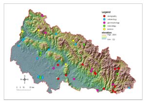
 Figure 5. Thematic classification of Transcarpathiaâs geosites. For geological settings, see Fig. 2. Nature conservation issues on Fig. 3.Â
Â
  Â
Table 2. Primary classification of the geoheritage sites of Transcarpathia based on their primary and additional interest (s)Â
Major interest | Additional interest (s) | Number of objects |
stratigraphy (S) | mineralogy, tectonics | 14 |
volcanology (V) | geomorphology | 13 |
geomorphology (G) | stratigraphy | 8 |
mineralogy (M) | volcanology, tectonics, geomorphology | 6 |
tectonics (T) | stratigraphy | 4 |
Â
Â
The thematic classification (Table 2, Figs 5, 6) is related to significant geological features of the sites (Table 2). This grouping emphasizes the major interest though 19 sites have two or three types of additional geological importance as well. The largest object number is related to stratigraphy and volcanology (14â13) while other sites are linked to geomorphology, mineralogy and tectonic interest.
Â
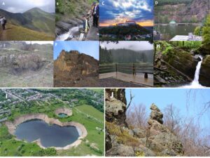
Figure 6. Geosites of Transcarpathia (the number refers to Table1). Stratigraphy geosites: A) Svidovetski cliffs (site 36), exposure of flysch sediments from Duklya nappe (major interest) with characteristic glacial relief (additional interest). B) Shypotska Suite outcrop (site 37): Exposure of the Lower Cretaceous Sipot formation of the Csornohora nappe (silicified clay-flysch) volcanic geosites: C) Mukachivska Castle (site 8). A monogenetic dacite lava dome remnant (photo by Bunda Sz. D) Volcanic outcrop ''Chorna Goraâ (Black Hill, site 21) with a touristic recreation center around the quarry lake. E) Basaltic andesite dyke in Suha nappe sediments, technogenic exposure (road cut). F) Siltse basaltic andesite volcanic neck (site 10) exposure of columnar jointed andesite, operating quarry geomorphology sites: G) Synevir Lake (site 28) formed by a landslide 10-12 000 years ago, the territory of Synevir National Park (Fig.3). H) Lumshorskiy Waterfall (site 5) was formed on layers of Dukla nappe, Middle-Upper Eocene sandstone, flysch, gravel and clay. I) Drone image of Solotvyno salt karstic features (site 35) with very rapid transformation of the actual morphology mineralogy site J) Zacharovana Dolina (Enchanted Valley, site 19) cliffs prepared from hydrothermally altered andesitic volcaniclastics (additional interest volcanology, geomorphology), the territory of Enchanted Land National Park (Fig. 3).
Â
Â
The stratigraphy-related sites represent major sedimentary units of the Carpathians (former Magura basin of Tethyan Ocean; GagaÅa et al. 2012; Nakapelyukh et al. 2018, Figs 6A, 6B) with outcropping Mesozoic and Paleogene formations (limestone, flysch). The volcanic sites (Fig. 5CâF) are mainly related to andesitic composite volcanoes (Figs 2, 5), but silicic volcanic remnants of the lowland regions are also included (e.g. perlite, rhyolite tuffs, sites 11â15, Table 1). The sedimentary formations contain Jurassic basaltic intrusive bodies (Novoselytske, Trostyanets Cliffs). The geomorphological heritage of the NE Carpathians is very diverse. Special erosional landforms of flysch nappes (cliffs, waterfalls Landslide Lake, Fig. 6 G, H) are present, but salt karstic features (Fig. 6I) are also included. The exposures of mineralization comprised typical polymetallic ores of the volcanic hydrothermal environment (e.g. Beregovo Caldera, Enchanted Valley, Fig. 6J), but unique shales with gold of the Marmarosh crystalline massif are also classified here.
The tectonic sites also represent the thrust belts and nappes of the alpine region. Limestone cliffs (Pieniny and Marmarosh Klippen Belt), olistoliths (Krosno Nappe) signify the history and geological diversity of NE Carpathians.
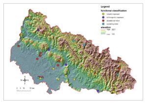
The functional classification refers to the physical appearance and size of the sites (outcrop, areal objects). The sites were classified into four major groups (Fig. 7): natural and technogenic exposures (road cuts), abandoned and operating quarries. The natural exposures include outcrops (e.g. Fig. 6B, D, E, H) and morphological objects (e.g. Fig. 6A, C, G, J) but occur in volcanic, sedimentary and metamorphic environments as well. The larger, variably sized morphological objects are erosional volcanic forms (e.g. necks, Fig. 6F, lava domes, Fig. 6C), and glacial, periglacial slopes and cliffs (Fig. 6A). Additional forms of other specific geomorphological processes (e.g. linear erosion, landslides) are also classified here (Fig. 6 G, J). The natural morphology has been considerably modified by human activities. The anthropogenic landforms were classified as technogenic exposures (e.g. Fig. 6E) and quarries (e.g. Fig. 6F). The construction materials (andesite, perlite, sandstone, clays) and minerals (e.g. ores, salt) were extracted from the 19th century (Richthofen 1860; Schafarzik 1904). Currently, there are five operating and 11 abandoned objects (Fig. 7) in the database.
Â
 Â Â Â Â Â Â Â Â Â Â Â Â Â Â Â Â Â Â Â Â Â Â Â Â Â Â Â Â Â Â Â Â Â Â
                                 Â
   Figure 7. Functional classification of Transcarpathiaâs geosites. For geological settings, see Fig. 2. Nature conservation issues on Fig. 3.Â
Â
 The Current Condition of the Sites
The fieldwork included the description of the current state of each site, with preliminary assessment of integrity, geological diversity, use limitations, current observation conditions, vulnerability, educational potential, safety, and association with other values parameters. The survey revealed that some of the 45 sites had already been modified by material extraction or natural degradation processes. The salt karstic features monitored during the last five years (Móga et al. 2017; 2019; Kurtyák et al. 2017; Gönczy et al. 2018) and the morphology are continuously transformed by collapse processes (Fig. 6J). The primary outcrop of the 2006 survey was destroyed. The morphological sites usually have high aesthetic values with several viewpoints to observe which are important assessment criteria in the scientific evaluation methodology (VujiÄiÄ et al. 2011). Hence, these are usually frequently visited objects (Mukachivska Castle, Fig. 6C, Svidovec cliffs â Fig. 6A). The operating quarries related to mineral extraction (zeolite) or rock excavation (andesite, Fig. 6F, limestone) function without permission to visit. The rest of the quarries are abandoned in various conditions (e.g. collapsed). Sometimes the debris along the walls has been forested, disturbing the chance to observe geological elements. Road cuts (Fig. 6E) are excellent exposures but sometimes difficult to visit for safety reasons.
Â
Discussion
Transcarpathia as the westernmost county of Ukraine includes the ranges of the NE Carpathians (Figs 1,2). The relief of the area is the product of a very complex geological history (sedimentation, nappe formation, horizontal displacement, volcanism, glacialâperiglacial environment) which is the main cause for the high regional geological diversity. There is a growing interest in geodiversity and geoheritage studies worldwide, which have generated a high number of inventory studies in recent years (e.g. Fuertes-Gutierrez & Fernandez-Martinez 2010; Szepesi et al. 2017; Taha et al. 2019). The systematic site inventories are based on scientific, aesthetic, protection and touristic relevance of geoheritage elements (; Fuertes-Gutierrez & Fernandez-Martinez 2010; Rolfo et al. 2015; Brilha 2016; Poiraud et al. 2016 Zangmo et al. 2017). Several regional compilations have been made in recent years in Ukraine (Manyuk 2006, 2016, 2020; Manyuk et al. 2020). The Ukrainian Geological Survey has proposed to declare 45 geological sites in Transcarpathia (Ivchenko 2004; Kalinin et al. 2006) representing the geological history of the county from Mesozoic sedimentation to the glacial processes of the Pleistocene. These in situ occurrences of geodiversity elements with high scientific, educational, aesthetic and cultural value are to fulfill the definition of âgeositesâ (Brilha 2016) or âgeomorphositesâ if the valued element has a geomorphological nature (Reynard 2005). Geoconservation describes a series of actions intended to preserve the geoheritage of a certain place (Brocx & Semeniuk 2007). Despite the large number of protected areas in Ukraine (Fig. 3), there is no relevance in the protection of abiotic nature and the concept of geodiversityâgeoconservation is not applied in the study area. Â
Our current review gives a basic description and potential use (e.g. mineral extraction, touristic exploitation) of each site (Table 1). The classification schemes (Table 2) used the primary lithology and physical appearance of the sites. All geological and geomorphological subregions of the county are represented in the database (Figs. 1, 2). The geoheritage is often threatened by human activities. There are five operating quarries (e.g. Fig. 6F) without legal permission to visit. The other mines (polymetallic ores) are closed and abandoned in various conditions. Continuous natural hazards threatened the salt karstic features of Solotvino (Fig 6I). In the past decades, these changes resulted in a loss of geological diversity. Our results verify that the characterization of the geoheritage elements is fundamental to define sustainable management strategies (e.g. Štrba et al. 2020 ). Despite the described geological diversity, the management of the protected areas is primarily related to biotic conservation. Despite the recommendations for protection of these objects, no changes have taken place in the past twenty years
Â
Connections with Regional Tourism
Although geoheritage is not a well-understood concept in the study area, some sites have long been used in tourism (e.g. Synevir lake, Mukachivska castle) with significant progress achieved in the past few years. The larger geomorphological features with good accessibility are the most visited places. Among the protected areas, hydrothermally altered cliffs in the volcanic range have been revealed in the Enchanted Valley (Fig. 6J). The âDruzhbaâ (friendship) cave located in the Transcarpathian Biosphere Reserve is a 50 m vertical hole with a fence. The Kamyani Vorota, a limestone gate-like erosional feature is also located in the biosphere reserve area. Both are inspiring landscapes with cliffs and arches that also attract tourists from the entire country. The Synevir lake (nature park, Fig. 6G) with the emblematic pine trees is the largest water reservoir in the mountain range. There are several spectacular cascades connected to the tectonic and geomorphological evolution of the region (Fig. 6H). The Shypot and Lumshorskiy waterfalls were formed on flysch sediments of the Duklya nappe. A good example of the utilization of the abandoned quarries is the water sport and recreation center Chorna Gora (Vinogradiv, Fig. 6D) where a small lake filled the quarry yard. In several cases, the geodiversity is associated with additional cultural values. The Mukachivska castle on an andesitic volcanic remnant is one of the largest medieval castles in Central Europe (Fig. 6C). This is an emblematic place of the Hungarian minority related to the war of independence (18th century). The wooden churches of the alpine mountain range are memories of the Ruthenian sacred architecture.
Geotourism activity that can link the geo- and the cultural heritage (e.g. Szepesi et al. 2017) is almost an unknown concept here, although it should be noted that the area is perfectly suited for geopark establishment. In 2012, a proposal was outlined that involves particularly important, rare (or unique), aesthetically attractive geological-geomorphological objects of scientific, educational and recreational significance (Kravchuk et al. 2012). It also includes archaeological, ecological, historical and cultural sites. The aim of the work was to establish the Volcanic Carpathians Geopark. Unfortunately, Ukraine has been continuously suffering from political and economic problems, so these infrastructural projects are not on the agenda.
Â
Conclusions
Geodiversity (like biodiversity) is a dynamic phenomenon which is changing at different rates and timescales. It is important to emphasize its significance in developing countries to avoid losses in abiotic diversity. Â Conserving geodiversity requires protection for nationally or regionally important objects, and this includes active management of sites and features. With this study, we highlight the importance and uniqueness of the geological and geomorphological diversity of Transcarpathia. As a summary we can state that geoheritage is absent from the planning of the protected areas (nature, biosphere reserve) and consequently, some geosites are being irreversibly damaged. This review is a good methodological starting point for expanding the database and emphasizing the importance of abiotic nature. An increasing public awareness, understanding and enjoyment of geodiversity is central to its conservation and future development.
Â
 Acknowledgements
János Szepesi and Zsuzsanna Ãsikâs work was supported by the European Union and the State of Hungary, co-ï¬nanced by the European Regional Development Fund in the project of GINOP-2.3.2-15-2016-00009 âICERâ.